Better than expected ***with track and voice***
May 10, 2018 § Leave a comment
Whereas I had been looking forward to the day to Coalport, I wasn’t looking forward to the day from there to Dunston Heath. The reason was that the route I’d picked out was there simply to get me across country from the top of the Welsh Borderland to the heart of Staffordshire. From there I could turn north again. The day was also going to be a long one.
In fact everything turned out much better than I’d expected. The route was a good mixture of non-busy roads, lanes and tracks. The farms in this area are mostly arable and the farmers seem to be more than normally conscientious – stiles in good condition, signposts clearly visible, paths sprayed. The weather played its part too – shirtsleeve walking all day. Oh, and there were pubs open just where I needed them.
Yes, a long and tiring day, but one that turned out much better than expected.

My thanks to the farmer!

Coalport to Dunston Heath
A voice recording can be downloaded at:
https://www.dropbox.com/s/o9371l0oy1demeh/180429_0182.WMA?dl=0
The snake, and other meetings ***with track***
May 9, 2018 § Leave a comment
I was looking forward to the walk from Wilderhope Manor to Coalport. It was relatively short and almost entirely off-road, meaning that I could take it easy and still get in at a time that would let me do those menial chores that even walkers have to do occasionally – the laundry for instance.
The stretch from Wilderhope Manor to Much Wenlock was essentially a recapitulation of the previous day’s Wenlock Edge experience. The only difference was that it passed behind several large limestone quarries, now all abandoned and used mostly as industrial storage sites. As far as I could see there has been no effort made to renaturate these quarries – no moving of spoil heaps, no removal of access tracks, no systematic planting. The quarries are eyesores now and they will stay eyesores.
Wenlock Edge was really a bit of a disappointment. Another disappointment was Telford’s bridge at Ironbridge; this was on the stretch from Much Wenlock to Coalport. The problem was simply that I couldn’t see it. It’s being renovated and therefore currently is encased in plastic sheeting.
Three meetings more than made up for these two disappointments. The first was that with Marc and Ali in the fields on the way to Much Wenlock. Conversation with other walkers in the sunshine in the country – that’s one of the things that makes long distance walking so enjoyable.
The second meeting was on the outskirts of Much Wenlock, on a small footpath just off the old railway line. There, no more than two metres ahead of me was a snake. About 75 centimetres long and two and a half centimetres thick, olive-green in colour. It slithered up the path away from me. Probably a grass snake, although I hasten to add that I’m no snake expert. This was in fact the first snake I’ve ever seen in Britain. A magnificent animal – and I never thought I’d ever say that about a snake.
The third meeting was at the YHA in Coalport. My roommate, Colin, turned out to be an exact contemporary of mine at Cambridge. Civilised conversation flowed, as you would of course expect!

Wenlock Edge

Yes, there is a Public Footpath there!

Much Wenlock churchyard

Wilderhope Manor to Coalport
Various unexpected things ***with track and voice***
May 8, 2018 § Leave a comment
Rich and Jude dropped me back at the campsite. How it had changed in just a few hours! When we had left there were plenty of empty pitches; when we returned the site was more than half full. The reason was simply that it was a Bank Holiday weekend. Mum and Dad and all the kids had arrived and were doing all the things that Mum and Dad and all the kids do on arriving at a campsite on a fine Bank Holiday weekend. That meant of course that getting off to sleep that night was a somewhat less peaceful experience than I had hoped.
I packed up the following morning (Saturday) and headed off along a track in the woods behind the campsite. Suddenly I chanced to glance to my right. There, sitting on tree stump looking at me, no more than five metres away, was a buzzard. Its head seemed almost silvery, shining in the sun. It flapped leisurely away.

Bridleway through Bringewood
I wanted to record this meeting, so I got out the voice recorder. Oh! The screen was obviously damaged. How, I don’t know. Anyway the thing still seemed to record, so I went ahead. I can’t use any of the screen controls, however. This means all my future recordings are going to be wing-and-a-prayer jobs.
I had hoped to head from the woods directly over to Craven Arms. Unfortunately the Downton Estate had other ideas, i.e., all the footpaths I had hoped to use were private. I had therefore to make a longish detour via Bromfield, followed by a lot of road work up to Wenlock Edge. Fortunately the roads – lanes really – were almost completely traffic free.

The colours of Corve Dale
At last I reached Wenlock Edge. What a disappointment! I’d been there almost forty years ago, on a field trip. My memory had played me false. There are in fact remarkably few views worth mentioning: those to the east, though pleasant, are not at all special; those to the west – those that would really be spectacular – are concealed by an almost continuous bank of trees.

It could almost be German – part of the path along Wenlock Edge

Wenlock Edge, looking east

Wenlock Edge

Wenlock Edge

At last a break in the trees – Wenlock Edge looking west
Finally I reached the YHA at Wilderhope Manor.

Burrington to Wilderhope Manor
Voice recordings can be downloaded at:
https://www.dropbox.com/s/v8hx6bop5z7cpkd/180429_0178.WMA?dl=0
and:
https://www.dropbox.com/s/1aaoqpjhmshb857/180429_0181.WMA?dl=0
A race against time ***with track***
May 7, 2018 § Leave a comment
First, another YHA experience. I received the warmest welcome imaginable when I arrived at the Kington hostel. Not surprisingly, because I was evidently the first guest of the week, on Thursday!
I also received an email from Rich and Jude saying they’d meet me the following evening at my campsite in Burrington and take me out for a meal. Obviously my planned sachet meal of beans and burgers would have to wait. There was only one problem, namely that the walk from Kington to Burrington was a long one and I would be hard pushed to get to the site and get pitched before Rich and Jude arrived.
Early to bed; early to rise; straight down into Kington for breakfast; then off towards Burrington. Everything seemed to click into place. The roads (and it was mostly road work) turned out to be acceptably walkable and the tracks turned out to be acceptably dry. I ended up making good time. I arrived at the campsite, pitched, showered and changed, and was waiting as Rich and Jude drove in. Phew, made it!
Then there was an excellent meal with superb company. Thank you both.

Bluebells at the roadside, on the road from Kington

…with my tent for scale

Kington to Burrington
An off-the-peg day ***with track and voice and video***
May 7, 2018 § Leave a comment
Thursday was one of the simplest walking days I’ve ever planned and done. It was an off-the-peg day along the Offa’s Dyke Path, from Hay to Kington. This is one of the National Trails.
The camp site where I was staying in Hay had excellent pitches – sheltered, dry and soft. What a change from Newgale! I had a good night’s rest and woke to a fine dawn. The day was going to be one without any obvious places to stop off for lunch, so a proper breakfast was called for. What better place than Angie’s, a cafe in Hay that opens early and provides just the sort of sustenance the walker needs – a bacon and cheese burger with masses of fried onions, accompanied by a pot of tea and served with a broad smile and lots of ‘darlings’ and ‘sweethearts’. Not a trace of PC anywhere.

The Wye at Hay
The walk itself was nothing special. Pleasant countryside to be sure, with views initially back onto the Black Mountains, but nothing special. Until Newchurch. This is no more than a knot of houses next door to a small church. At the church gate was the smallest of handwritten signs – ‘Tea, coffee and biscuits’. Remembering the Shepherds’ Church at Pyecombe, I went in. Sure enough, there was refreshment again. An open door, a place to rest and prepare for the next stage, and everything on the basis of trust. That is St Mary’s Newchurch.

Yesterday’s Plan A: the Black Mountains seen from the lane above Hay

Newchurch

St Mary’s Newchurch

A haven of peace
The great thing about National Trails is that they’re mostly off road. The Offa’s Dyke Path is no exception. There were two outstanding stretches of downland walking: Disgwylfa Hill and Hergest Ridge. The latter provided the question for the day. Why on earth is there a stand of a dozen full-grown monkey puzzle trees right out in the middle of nowhere?

The stand of monkey puzzles

Yes, genuine monkey puzzles!

Hay to Kington
A video of the morning sun shining on the River Wye below the bridge at Hay can be downloaded at:
https://www.dropbox.com/s/fn0x5i0xi7nmo8t/VID_20180503_093553857%20Wye%20at%20Hay.mp4?dl=0
A voice recording made on starting out from Hay can be downloaded at:
https://www.dropbox.com/s/2pfzhyrydahfi2g/180429_0175.WMA?dl=0
A voice recording made in St Mary’s Newchurch can be downloaded at:
https://www.dropbox.com/s/wodyh2olzb656zj/180429_0176.WMA?dl=0
Choosing plans ***with track***
May 3, 2018 § Leave a comment
It was while I was sitting in the bar of the New Inn on the Monday night that I realised my plan for continuing the walk on Wednesday might not be quite as do-able as I had hoped. ‘The weather on Wednesday’s going to be awful’, I heard somebody say. Sure enough, the forecast was for rain, rain and more rain.
I looked again at the map, trying to devise alternatives that would get me successfully from Bwlch to Hay on what was evidently going to be thoroughly wet day. Plan A (my original plan – a high-level route across the Black Mountains) was surely not going to work. Plan B (a short section over the hills immediately north of Bwlch followed by roads from Talgarth to Hay) seemed better. Plan C was roads alone – back lanes where possible.
I woke several times on Tuesday night – each time it was raining heavily. It was raining too when I got up and breakfasted. Plans A and B were now clearly both non-starters. Plan C it had to be.
The condition of the lanes I walked between Bwlch and Talgarth was enough to convince me that any off-road walking would have been stupid. Everything was covered in reddish-brown mud; the tracks into the fields were in many instances impassable on foot; the streams everywhere were reddish-brown rivers. As to the hills – well there wasn’t much of them to see.
I found a cafe in Talgarth for a mug of tea and a bun. Then I set out for the last stretch into Hay. By now the rain had stopped and the sky was beginning to clear. And yes, those did seem to be hilltops coming into view! As I eventually came into Hay I thought about which of the plans I would have chosen if I’d known only about how the day would finish. It would have been Plan A.

Llangorse Lake looks beautiful, but just look at the gateway!

That’s Plan B in the clouds!

An overall impression of brownness – the Wye from the bridge at Hay

Bwlch to Hay
The walk’s first bouquet
May 2, 2018 § Leave a comment
Yesterday (Tuesday) was exactly what a rest day should be – restful. I let my legs recover from the eight days continuous work that they’ve just had.
The bunkhouse where I spent the rest day was exactly what a bunkhouse should be. In fact it was more. OK, I was the only resident, but still. I had a two-bed room with its own sitting area and en suite bathroom. And I do mean bathroom! Yes, the walker could again lie back in his own private full-size bath.
Meals? A continental breakfast is included in the price – you make your own in the communal kitchen – and for evening meals you simply go down to the bar. The meals there are excellent, as is the beer. On the second night I was there the pub was being presented with its CAMRA Regional Pub of the Year Award. Wasn’t it lucky I didn’t start by ordering a pint of Stella?
Neal and Sarah, you’re doing a fantastic job. You’re setting the standard for bunkhouses. A bouquet from blogger to the New Inn, Bwlch. The website is www.beaconsbackpackers.co.uk
Happy Birthday, Lauren Mary
May 2, 2018 § Leave a comment
Lauren Mary
With my fondest love to you and your lovely family
Dad
PS. With this year a photograph!

Fford y Darren
Charity and charities
May 1, 2018 § Leave a comment
The thing about a rest day on a walk is that your body rests but your brain doesn’t. All those thoughts you had on the days you were walking, all those conversations you had with people you met, all those sights you saw and sounds you heard, all these things come back to mind and demand your attention.
I’ve planned to stay in five youth hostels on this walk and in both those I’ve stayed in so far there’s been lively talk about the YHA and how it is run. Evidently people are now starting to scream. Richard, an experienced peak bagger with whom I shared a room on Sunday, was particularly forthright. He talked about the dichotomy that exists between the YHA as a charity (getting young people out into the country, with volunteers doing much of the work and donors providing much of the money) and the YHA as a commercial hotel chain (new hostels in city centres, built – or rebuilt – for the purpose of making money, in direct competition with other accommodation providers). I can only concur with him.
What is charity? It’s giving to those who do not have and to those who are in need. What is a charity? In this country it’s any organisation that manages to put together some plausible charitable agenda and thereby obtains from the Government a substantial tax advantage. Once registered as a charity the organisation can use this agenda to hide a wealth of non-charitable activities. Clearly the YHA is doing this.
What is needed is not a centralised hostel operation, where bean-counting rules, where everything has its price, and where anything that in fact needs charity is cut out and closed. What is needed instead is a loosely linked association of independent hostels and bunkhouses, ones where the proprietors provide the facilities that their local market wants at the prices the market is prepared to pay. Pie in the sky? Not at all! I’ve stayed in many such hostels on previous walks; I’m staying at others this time; indeed I’m writing this post from one of them. These places are springing up across the country in the very areas in which the YHA is closing its own hostels down. And it is exactly these areas that are the ideal ones for getting young people out into the country.
Charity is always a great thing. Charities are not.
A day of many parts ***with track and voice and videos***
May 1, 2018 § Leave a comment
Today (Monday) was a day of contrasting parts. The first of these was the part down to Brecon, the second the part to Talybont, and the third the part to Bwlch (pronounced Boolkh, for those of you who are not fluent Welsh speakers). The weather was kind the whole way, and for some of the time it would have been possible to walk in shirtsleeves. What a change from the weather that had been forecast!
The hostel at Llywn-y-celyn was nowhere near full, but the breakfast time there was close to chaotic. The two charming visitors from Regensburg who had been overnighting there were shaking their heads in disbelief. I left and headed down the valley towards Brecon, following a small footpath signposted by the National Trust. Soon it was my turn to shake my head. ‘You’re taking me along that? But it’s just a five-metre-wide channel ankle-deep in red-brown mud!’ Fortunately there were trees at the side with branches that offered an alternative high-level route. I’ll let you speculate on my exact technique.
The path led on to lanes that took me through Glyn Tarell down into Brecon. The land flattened off and opened out and I could look back at the hills. Before me was now the Usk valley, with the prospect of a completely different style of walking.

Looking SW from Glyn Tarell

The Glyn Tarell lane

Cilwhybert Castle Mound

That’s more like Spring
Brecon is the end-point of the Brecknock and Abergavenny Canal, another of those engineering feats of the past that leave you asking why. I followed the towpath to Talybont, relishing that great feature of canal-side walking – the lack of hills. What an idyllic place! The canal itself winding across the landscape, the trees sheltering it in parts, the narrow boats, the perfectly preserved stone bridges, and the Usk itself flowing along in its valley below.

Brecknock and Abergavenny Canal

Brecknock and Abergavenny Canal, looking S

Brecknock and Abergavenny Canal

Brecknock and Abergavenny Canal
Particularly memorable was the Brynich Aqueduct, which carries the canal over the Usk. A heron was standing on the aqueduct on the bank of the canal. I stopped. Slowly and deliberately it dived forward into the water, then came up with a fish in its beak.

Brynich Aqueduct and River Usk

The heron on the aqueduct
There were several canal-side pubs to tempt the walker, but I didn’t give in. I wanted instead to get to Talybont and then on to Bwlch. The question was which route I should take from Talybont. Remember what I said earlier, that canal-side walking avoids hills? That’s great, but the down side is that canal-side routes are almost always longer. This time the choice was to stay on the towpath and cut up to Bwlch at Llangynidr, or to walk directly to Bwlch along the A40. The difference was about three kilometres, so I chose the direct route. The A40 is a main road certainly and therefore something I would usually avoid. It has the widest of verges, however, and therefore is perfectly safe.
Tomorrow is a rest day. I need it!

Llwyn-y-celyn to Bwlch
A video – my apologies for its darkness – looking from Glyn Tarell into the central Brecon Beacons can be downloaded at:
https://www.dropbox.com/s/8jq7v32frwpcznt/VID_20180430_103431420%20Glyn%20Tarell%20lane.mp4?dl=0
Two videos taken on the Brecknock and Abergavenny Canal, the first of the Brynich Aqueduct and the second of a passing narrow boat, can be downloaded at:
https://www.dropbox.com/s/82x2mvl39946nha/WP_20180430_13_19_09_Pro%20Brynich%20Aqueduct.mp4?dl=0
and:
https://www.dropbox.com/s/lff3xstguquhgyr/WP_20180430_14_33_37_Pro%20Brecknock%20Canal.mp4?dl=0
Voice recordings can be downloaded at:
https://www.dropbox.com/s/7pslysg5l8yqg5b/180426_0170.WMA?dl=0
and:
https://www.dropbox.com/s/v1s4cgd6bfawufp/180426_0172.WMA?dl=0
Back to the roads ***with track***
April 30, 2018 § Leave a comment
The weather yesterday (Sunday) looked very much better than forecast. Dry and cloudy, but with a strong wind blowing from the south east. I decided to stick with the road option, however. Was this me chickening out of another day on the hills, especially on hills that are seriously steep, or was this simply the sensible approach for a solo walker carrying a sizeable pack? The deciding argument was in fact that the hill option after a period of rain would involve one potentially unpleasant river crossing.
The road option to Trecastle turned out to be unexpectedly good. The road – really no more than a lane – was unhedged and mostly on the crest line, thereby simultaneously maximising views and minimising effort. It was also almost traffic-free. Part of the way along it I met up with the only two other people who’d been staying at the Llandeusant hostel. They were photographers making a video promoting ‘the car in the landscape’ – what exactly that means and who is funding it I didn’t ask. The wind had by now freshened, so they weren’t able to use their photo-drone. That was a pity, because there were several red kites about. Evidently these get quite inquisitive about this strange flying object!
I reached Trecastle shortly before midday. Yes, the only pub was shut! I immediately had the horrible thought that pubs in some parts of Wales might still be shut on Sundays. I’d no need to worry, however, as this pub duly opened at 12 noon exactly. I mentioned to the landlady my memory of dry Sundays in Wales. She replied, “Coming here these days is certainly like stepping back in time, but not that far!” Then she showed me just how much things have indeed changed here: the salad I got to accompany my simple lunchtime sandwich was memorable – fresh everything, with a dressing that would make many master chefs look to their laurels. For your information, this was the Castle Coaching Inn.
From Trecastle onwards I had roads that managed simultaneously to maximise effort and minimise views. They also seemed to be the preferred race track for a large number of our two-wheeled chums. Fortunately the rain that had been promised never materialised. Finally I reached the hostel at Llwyn-y-celyn, exhausted.
Skyline looking S from near Mynydd y Llan

River Usk at Pantysgallog
A small postscript. On the final stretch up to the hostel I passed another walker – younger than me, obviously fit, and very impressively outfitted. Imagine my surprise when he says to me, ‘I see you’ve got one of those Ultra Lightweight rucksacks. I’m thinking of getting one. What are they like? What do you think?’ Could it be that I’m walking in style?

Llandeusant to Llwyn-y-celyn
That feels better! ***with track and voice and video***
April 30, 2018 § Leave a comment
My Friday finished up in a pod, again. Once again I’d booked to camp and once again the conditions were less than optimal. A pod was available (and this time with a TV, albeit one that didn’t work) and the price was right, therefore the walker spent another comfortably warm night.
Today (Saturday) dawned fine. This was fortunate because this was the first of the days I’d planned for getting out onto the Brecon Beacons. I nevertheless wasn’t completely sure what the conditions would be underfoot after all the recent rain. I needn’t have worried. The surface was excellently soft with very little mud. The Roclites gripped even on the steepest gradients.
Three things stood out today. Firstly, the sink holes on the limestone; secondly, the skylarks; thirdly, the red kites. Sink holes – dozens of them, ranging up to thirty metres across and ten metres deep. Skylarks – dozens of them, singing both in the air and on the ground. Red kites – dozens of them, circling and soaring and diving.
Oh, and a woodpecker to remind me of the cherry tree at home.
The final few kilometres were tiring, especially the long climb up the rocky dip slope of Garreg Las. Eventually I reached the hostel at Llandeusant, with a wonderful sunset as a bonus.
Tomorrow is forecast to be wet, and in that case I’ll opt for road walking again. Today I had a day on the hills – I feel better already.

Looking back to Bryncoch

Carreg Cennen Castle

The first limestone quarries

Sinkholes everywhere

Sinkholes

Sunset at Llandeusant
Note added later. Wow! Garreg Lwyd (Moel Gornach) turned out to be my very first Hewitt, and therefore also my very first Nuttall. And Garreg Las was my second. I can now hold my head up in the hill-bagging community. (For those poor benighted souls who don’t know what Hewitts are, they’re hills in England, Wales or Ireland over 2000 feet high (610 metres) with a drop of at least 30 metres (98 feet) all round. And Nuttalls are of course hills over 2000 feet high (610 metres) with a relative height of at least 15 metres (49 feet) on all sides. There!)

Garreg Lwyd (Moel Gornach)

Bryncoch to Llandeusant
A video of the lower part of the Black Mountain, with sinkholes and limestone quarries in abundance, can be downloaded at:
https://www.dropbox.com/s/ql510t4wdr2nhyo/WP_20180428_10_42_12_Pro%20Black%20Mountain.mp4?dl=0
A voice recording made shortly afterwards can be downloaded at:
https://www.dropbox.com/s/zyc26319routq4g/180424_0169.WMA?dl=0
Bwrdd Arthur ***with track***
April 30, 2018 § Leave a comment
Today (Friday) was more of the same: roads, rain, muddy paths, and little incidents to lift the walker’s spirit. There doesn’t seem to be too much point in writing more about the first three, so I’ll concentrate on one of the fourth.
I bussed back to Llangyndeyrn and started off from where I had finished yesterday. (At the bottom of the path where you saw all that Old Red Sandstone outcrop. You did notice it, didn’t you?) The first couple of kilometres were pure murder – it was one of those hills that seem to get ever steeper the higher you climb. Eventually I reached the crest, where I had originally planned to turn off and walk across some open-access land that is marked on the map, intriguingly, as Bwrdd Arthur, a prehistoric burial ground. Unsurprisingly, given the fact that it was raining, this now looked an unattractive option. I therefore took a clearly marked track that cut round the edge of the land. Or, rather, was shown on the map as doing that.
Of course there was a hitch, namely that the track simply stopped at a small farm. The farmer informed me, smilingly, that the track no longer existed. Could I get further? Yes, but only by going my originally planned route. Which I did.
It all turned out brilliantly. Wall-to-wall archaeology going back to Neolithic times. What’s more, the path through the area turned out to be as walkable as a hill-top path can reasonably be expected to be on a wet day. Not the conditions for photography, however.
So who was this Arthur, and why did he get such a burial chamber? Answers by email, please.
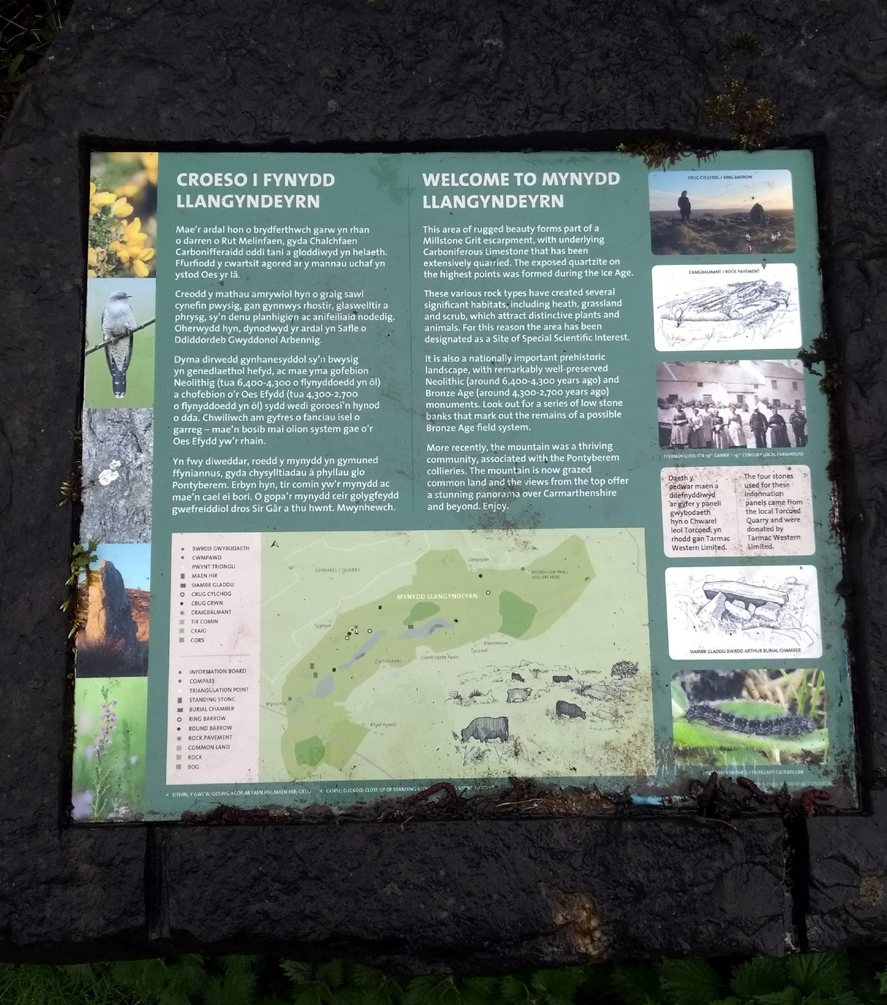
Mynydd Llangyndeyrn

Llangyndeyrn to Bryncoch
Yet more roads ***with track and voice***
April 27, 2018 § Leave a comment
Meidrim to Carmarthen via Llangyndeyrn, mostly by roads. Not the most interesting of days, to put it mildly. On and on, and after that a bit more on and on.
Just occasionally there are those little incidents that make it all worthwhile. First the magnificently red fox that crossed the road ahead of me, slowly and quite mindless of my presence. Then the buzzard taking off and showing its colours. Then the red kite giving flying lessons to a seagull and some crows. Then the grey squirrel on the back lane giving me some lessons in running and jumping.
I passed through Carmarthen at lunch time and was guided by a friendly traffic warden to what he described as the best cafe for lunch – Merlin’s Kitchen. Excellent. Then it was on to Llangyndeyrn, with a bus back to Carmarthen to my B&B at the end of the day. My room had a full size bath, no less. A road walker’s dream.

Farewell to the wigwams

The first flowers of Spring

A hint of tomorrow: standing stone north of Llangyndeyrn

Meidrim to Llangyndeyrn
A voice recording made as I started out can be downloaded at:
https://www.dropbox.com/s/w0lw3y10cd6i4cm/180422_0168.WMA?dl=0
Size matters ***with track***
April 27, 2018 § Leave a comment
My night in the pod was a deal more restful than my expected night under canvas would have been. I was therefore feeling a lot more positive when I set out from Rosebush. The weather was better too, with even a (small) patch of blue sky to raise the walker’s spirits.
There was only one problem – the state of the tracks. I had found out on my way from Newgale to Rosebush that the rain had made many of the tracks lethal – and by lethal I mean slip-over-and-break-your-leg lethal. The sensible alternative in these conditions (especially when you are walking alone) is to walk mostly on roads.
I don’t mind some road walking, but days made up almost entirely of road walking are definitely not for me. This applies especially when the roads are seemingly designed to go upward for ever with a walker-unfriendly slope. Gisela told me last week on the Westweg that the German word for such a slope is Himmelsleiter. Very apt.
Road walking can also be mind-numbingly monotonous, even when the countryside through which you are passing is not visually unpleasant. Occasionally you get something special. Yesterday (Wednesday) it was the stretch of roadside with wild garlic.

Looking back towards Rosebush

The roadside
The target for the day was a campsite just outside Meidrim. This is one that also provides outdoor adventure activities for youth groups. I was absolutely alone, however, so the owner let me use one of their pre-pitched wigwams. Six metres across and almost four metres high, it was a considerably more roomy camping experience than I’m used to! But much too big for my rucksack.

My new tent!

A bit more space than usual

Rosebush to Meidrim
Hospitality ***with track***
April 26, 2018 § Leave a comment
Let’s start by making it clear that the first day was a very tiring one. Now let’s make it equally clear that the second day was a very tiring one and a very wet one. Tiredness and wetness – the walker’s two bugbears – together.
I came into Newgale on the first night with the prospect of pitching my little tent in the wind and the rain on a site with hardly a skerrick of protection. Sensibly, I first went along to the pub next door, the ‘Duke of Edinburgh’, to check if they had a bed free. ‘No’, said Jayne, the duty barmaid, smiling, ‘there’s no room at the inn.’ Later, after I had eventually managed to pitch, I went back to the pub for a meal. I said to Jayne that it seemed to me surprising that all their rooms were full (and this on a wet Monday night in April – hardly the height of the tourist season in West Wales) but their car park was entirely empty. ‘We have a lot of workmen’, she said. Clearly they come on foot. When I left, there was no one else around anywhere. Obviously the rooms were empty but letting one out to an exhausted walker was just too much trouble. Thank you, Jayne, but if it’s all the same to you I won’t be coming back to you again.
I started off the following day (Tuesday) with a breakfast of tea and a blueberry muffin at the cafe in Newgale. Then it was off for lots of tiredness and wetness. I came down off one rain-swept hill into a farmer’s yard. He was in his barn working on his tractor. I asked him if I could shelter for a few minutes. ‘Yes’, he said, ‘but my workshop will be drier. And why not come into the house for a mug of coffee?’ Then it was half an hour of splendid conversation, with advice on the best paths thrown in. Thank you, John.
Lunch time saw me in Spittal, where fortunately the ‘Pump on the Green’ was still open. I say ‘fortunately’ because it was close to 3 and I was the only customer. ‘Let me make up the fire’, said the landlord, ‘then we can dry off your jacket a bit’. Five minutes later he’s back with the bowl of soup I ordered. ‘My wife has asked if she could put that jacket into the drier for you’. Nothing was too much trouble. Thank you!
Finally I reached the campsite at Rosebush. Another wet and windy pitch was in the offing. ‘Do you by any chance have a pod free?’ I asked the lady at reception. ‘Yes’, she said, smiling. So the day ended for me with a warm and dry night on a proper roll-out bed, with a heater to dry off my clothes, with a kettle to make tea, with power sockets for charging, and with a friendly (and full) pub only five minutes walk away. Thank you!
Hospitality of the finest kind, with one glaring exception.

A muddy crossing

Newgale to Rosebush
The first day ***with track and voice***
April 25, 2018 § Leave a comment
Overnight in Haverfordwest (because there aren’t any buses on Sundays to take me further), then bus to St David’s on Monday morning followed by a walk out to my starting point on the coast. This is the furthest west point of mainland Wales; the farmer there told me it is locally called the copper mine. From there it was simply a straightforward walk along the Pembrokeshire Coastal Path to the day’s end point at Newgale.
‘Straightforward’ is a very versatile word. Its meaning depends so much on the balance between the ‘straight’ and the ‘forward’! In this case there was a lot of forward and very little straight. There was a lot of inning and outing and upping and downing.
I was last on this coast more than twenty years ago, supervising student mapping. Great memories of four great students: Dirk, Frank, Jochen and Peter. Thanks to you all.
How things have changed. As I stopped for a break at Porth Clais (this was one of the ‘in’s), there arrived a group of about 25 university students. I didn’t ask, but I assume they weren’t geology students simply because they didn’t have any hammers. On second thoughts, however, they might have been geology students, either (a) because hammering might now be banned for environmental protection reasons or (b) because hammering might now be banned on health and safety grounds. Helmets in the field is a sensible rule, as is eye protection, but high-vis jackets in a group on a well-trodden path seems to me to be going over the top. Not to mention one of the leaders ostentatiously carrying a largish box marked ‘First Aid Kit’.
Anyway, it was time to go on. Solva (another ‘in’) found me in a cafe for tea and a birthday slice of carrot cake, then the final stretch to Newgale. It was now blowing horribly on the cliff tops, with at times a lot of the wet stuff too. I found the only halfway sheltered spot on the campsite (behind a parked van) and managed to pitch.
Tired? You could say that. Alternatively you could say exhausted.

Ramsey Sound looking SW from above the copper mine

Ramsey Island and The Bitches, from above the copper mine

The copper mine, Ramsey Sound and Ramsey Island

Ramsey Sound, looking N from the copper mine

Looking SE over Porthlysgi Bay, from the coast path

Porth Clais

Copper mine to Newgale
A voice recording made at the very start of the walk can be downloaded at:
https://www.dropbox.com/s/6xc304c9vx9ghkz/180421_0166.WMA?dl=0
Almost ready…
April 17, 2018 § Leave a comment
The rucksack is packed!
Flicka and I head off tomorrow to England, then next Sunday I plan to travel down to Haverfordwest to spend the night. The following morning should see me on the bus from there to St David’s, from where the walk begins. And from then on…
An updated plan is on one of the side pages.
The next instalment
April 8, 2018 § Leave a comment
Those of you who’ve been waiting impatiently for the next instalment of ‘Going It Alone’ can now relax. Here it is.

Strider, Number 140, April 2018
As before, to make the article legible you simply click on the photo. If that doesn’t work, here’s the text.
“I pointed out in my previous contribution that there are evidently a large number of go-it-aloners in the LDWA – very many more than their relatively subdued profile in Strider would suggest. They’re active long distance walkers – we’ll accept that – but what do they actually do? And why do they opt to go it alone, instead of taking part in organised walks or events? Finally, why aren’t they telling us all about it?
Don’t expect me to give you statistically representative answers to questions like these! I haven’t carried out surveys or sent round questionnaires; neither, I suspect, has anyone else. All I can offer is my own prejudiced opinion, prejudiced because I’m part of the group of people we’re talking about here – I’m both an LDWA member and a go-it-aloner.
I’ve stressed that there’s no such thing as ‘the’ long distance walker. Similarly there’s no such thing as ‘the’ go-it-aloner. There would seem to be three main types of people who go-it-alone. Firstly, there are people who research paths on the LDP directory and other similar sites, who select the paths they want, who download details of those paths and obtain the necessary guidebooks and maps, and who then go off and walk. Secondly, there are people who plan and develop their own walks themselves. Thirdly, there are people who simply go off and walk. There are undoubtedly go-it-aloners who are sometimes of one type and sometimes of another. There are also go-it-aloners who sometimes aren’t, for instance people who also take part in group walks and challenge events. As I stressed last time, we’re all individuals!
Go-it-aloners of the first type would appear to want their walking to be as trouble-free as possible. That’s why they deliberately choose paths that have been walked thousands of times before, by thousands of people, and for which there are maybe hundreds of published guides and reports. Go-it-aloners of the second type clearly don’t want this luxury. They set themselves the task of getting from A to B, then plan for themselves how best to do it. They also prepare themselves to cope with problems that arise if and when their plan doesn’t work out in practice, for whatever reason. As to go-it-aloners of the third type – they’re explorers. The routes they take cannot be planned in advance, at least not in any detail.
So much for the evident differences. Now to the similarities, which are considerably more important. The overriding trait common to all go-it-aloners, of whichever type, is the desire to lead your own walk. This means wanting the freedom to decide for yourself exactly where you go and when, both before you start out and after you’ve set off. It also means being prepared to accept the responsibility yourself for things that go right and for things that go wrong. It’s your walk, and you’re leading it!
This desire to lead your own walk is surely the main reason go-it-aloners avoid organised walking. They don’t mind a walk being organised (which is why they’re often more than happy to follow a route described in a guidebook), but they don’t want to be organised themselves. They want the freedom to choose their own pace and to vary it as necessary; they want the freedom to go ‘off piste’ when something they see interests them, or even to change the whole course of the walk; they want the freedom to take a break now (not in an hour’s time), or to keep going despite the weather; they want the freedom to take that obvious short cut across the fields (or not to take it); and so on. This critical idea of leading your own walk is of overwhelming significance to go-it-aloners. I’m going to keep coming back to it again and again in subsequent contributions.
Finally, at least for now, that final question. Why is it that go-it-aloners seem so loth to publicise what they do, to tell us about where and when they’ve walked, and how? Why are there in Strider and on the LDWA forum so few reports of long distance walks carried out independently by individual LDWA members? Perhaps the most obvious answer, particularly for go-it-aloners of the first type, is the understandable reluctance to invest what could be a large amount of time and energy in writing yet another of those interminable reports about walking the West Highland Way – I use that only as an example! Go on, admit it, other people’s reports about walks along well trodden paths are not usually the first items on your reading list! Such reports are great when they’re done well, but it’s so easy to do them badly. There has to have been something special about your particular walk to make it worth reporting, and the report itself then has to have wide appeal. I run a blog during my long distance walks, but I deliberately make it available only to family and friends and those I meet on the way. They are the only people I can think of who can be expected to want to spend valuable time reading about what I’m doing or what I’ve done. I suspect lots of other go-it-aloners have a similar attitude.
There’s a second answer to the question of why go-it-aloners are so reluctant to report what they do. It applies particularly to the second and third types. This answer – it seems at first sight to be a thoroughly selfish one – is rooted in that idea of ‘leading your own walk’. Consider, for instance, how you’d feel if somebody borrowed your favourite boots. You’ve bought them, you’ve broken them in (assuming they do need breaking in), and you and they are now old friends. It’s like that with a walk you’ve planned yourself and done. It’s yours; it’s not for anybody else.”
Familiar feelings
March 24, 2018 § Leave a comment
I’m looking after myself at the moment, as always at this time of year. Not for long though, as Flicka is now on her way back from her usual yearly visit to our Australian family. I miss her!
One of the things that changes whenever I’m looking after myself is my diet. The meals are healthy – there’s no doubt about that – but you wouldn’t describe them as overly adventurous. There are always memorable ones, of course. This time it was the cauliflower cheese. Simplicity itself, with a sauce that was smooth enough to get me a surefire invitation onto Celebrity Master Chef. I’m expecting the phone to ring any time now.
What else has been memorable in these weeks? One thing in particular – the invitation from Ute to give a talk to her English language class at the Volkshochschule in Breisach. What a strangely familiar feeling – standing up in front of a class again! I haven’t done that for almost four years. The topic had nothing to do with geology, which was a bit of a relief. Instead it was on – yes you’ve guessed! – long distance walking. There were ten listeners and I think everyone went away happy. I certainly did. What was interesting is that I finished exactly on time, just like in the old days. I evidently haven’t lost my touch.

Now what on earth is the umbrella there for?
Updated plans
February 24, 2018 § Leave a comment
There’s less than two months to go now, and the preparations for Corner-to-Corner seem to be going well. Time then for an update for you!
The blog page with the plans has been updated, and it now includes a Dropbox link to a .kml file giving the proposed route. The details of the individual days have in places been altered slightly, as have the accommodation details. Provisional? Yes, as always!
What’s still to be done? Well on my side there’s the new set of waypoints to generate for the Garmin; then there are the screenshot maps to make for the mobile phone; finally there’s the checking over of the kit. And on your side? Need I say it? Firstly, there’s the matter of re-enrolling in ‘Introductory Geology’. (The first field trip will be to the coast near St David’s. With prizes for any good specimens of Paradoxides davidis!) Secondly, there’s the choice of footwear – perhaps something specifically ‘For Walking’. Thirdly, don’t forget to get in touch as soon as possible if you want to walk part of the way with me, however long or short, or if you simply want to meet up.
This post carries a health warning
February 18, 2018 § Leave a comment
‘Walking can be dangerous and is done entirely at your own risk’ – from the WalkHighlands site (http://www.walkhighlands.co.uk/)
I concur entirely, especially after my experience last week. There I was, walking along in the city in which I used to work. Suddenly I was confronted with this massive new billboard. ‘Vive le Moment’, it read. ‘Moi aussi’, I thought, instinctively, before remembering among other things that I don’t speak French.

Vive le Moment
What a masterpiece of visual communication this is! Just look at the problems the advertiser had to overcome. Firstly, cigarette advertisements have legally to carry health warnings; these have to cover a certain minimum proportion of the advertisement area – about 15%. Secondly, cigarette packages have also to carry health warnings, which must be clearly visible. Now look at what was done. Firstly, the health warning on the advertisement was defined to include both the text of the warning (I’ve outlined this with a black box) and the plain white space around it; then that text was made as brief as possible (‘Rauchen ist tödlich’) and as small as possible. Secondly, the cigarette packages shown in the advertisement were positioned with a flair for perspective that Leonardo da Vinci would have envied. The health warnings on these packages are all clearly visible (I’ve outlined them with white boxes), but they’re completely unreadable. Truly a textbook example of creative problem-solving!
So where is this billboard? I’ll give you some hints. It’s in one of the only two countries in the European Community that still permit street billboard advertising of tobacco products. And it’s not in Bulgaria.
Anything but!
January 24, 2018 § Leave a comment
We’ve had some magnificently warm and sunny days recently, so my favourite paths across and around the Kaiserstuhl have duly been walked, many times. Jacketless walking in southern Germany in December and January – I can hardly believe it.

December – the grasslands

December – the beech woods

January – the snow melt
These walks are now old friends. There’s always something new to discover on them, either about the area itself, or about the people in it, or about something else entirely. The other day, for instance, I spent what seemed like hours walking along arguing with myself about one particular use of a simple English word – the word ‘but’. Have I finally flipped? Possibly. Or, instead, might I not have been taking advantage of that most wonderful thing about long distance walking – you have so much time with so little distraction?
The context in which I was questioning the use of that word ‘but’ is the sentence in the Lord’s Prayer that reads ‘And lead us not into temptation, but deliver us from evil’. Again I’m using the version that appears in the 1662 Book of Common Prayer, which in turn is based largely on Tyndale’s 1525 translation of the New Testament. My question was why Tyndale used ‘but’ as the conjunction in that sentence. Did he mean this ‘but’ to have the sense of ‘however’ or ‘nevertheless’ or ‘anyway’, or did he mean it to have the sense of ‘instead’ or ‘rather’, or did he mean it in some other sense entirely? The problem with the first two usages – these are the ones that are usual today – is that in neither case is there any defensible idea of what temptation really is. Nor is there any defensible idea of the relationship between temptation and evil. Here’s the first usage: ‘And lead us not into temptation, however deliver us from evil’. Temptation is evidently bad (because we’re asking not to be led into it), however it’s clearly not as bad as evil (because we’re asking to be delivered from evil in any event). Now here’s the second usage: ‘And lead us not into temptation, instead deliver us from evil’. Temptation is now possibly even worse than evil (because, faced with the choice of not being led into temptation or being delivered from evil, we’re asking to be delivered from evil).
Temptation seems to me to have got itself an unjustifiably bad name! Don’t get me wrong, but I can’t see anything bad about temptation per se. Long distance walkers are often tempted, for instance to sit with a beer in the sun outside a pub when they should really be on their way, or to sneak a ride on a bus when the weather is truly dreadful, or to take a convenient short cut despite the fact that it leads through property that very obviously is private, and so on. And, yes, long distance walkers do occasionally give in to temptation! What on earth is necessarily bad about that?
Pope Francis, a man for whom I otherwise have great admiration, has recently muddied the waters here: e.g., https://www.upi.com/Top_News/World-News/2017/12/08/Pope-calls-for-change-to-Lords-Prayer-to-clarify-temptation-passage/1101512737763/. He has suggested that ‘Lead us not into temptation’ be replaced by ‘Do not let us fall into temptation’, arguing that loving parents don’t lead their children into temptation. To that I say simply, ‘Sorry, Big Guy, on this you’re completely out to lunch. What you’ve missed is that it’s not temptation per se that is the bad thing; it’s the doing of evil that is bad – the doing of evil that sometimes results from giving in to temptation.’ It is in fact completely natural for parents to lead their children into all sorts of temptation, especially where the giving in to the particular temptation can result in the doing of evil. Parents do this firstly to show what the consequences can be, and secondly to show how not to give in. Parents do not shield their children from temptation; they help their children learn to stop themselves from doing evil.
Which leads me back finally to the sense in which Tyndale used that little word ‘but’. He used it in the now-archaic sense of ‘without it also being the case that’. (You’ll find examples of this usage in eighteenth century English novels: “John was the most caring of husbands. He did not come home but enquired of his wife’s health.”) That sentence in the Lord’s Prayer says simply ‘And lead us not into temptation, unless at the same time you also ensure we do no evil’. To me this sounds like a remarkably sensible request.
Was all of this a waste of good walking time? Anything but!
Thank you, Alison!
January 21, 2018 § Leave a comment
The detailed preparations for Corner-to-Corner are continuing apace. There are now some dates for your calendars; you’ll find these on the appropriate side page of the blog. Needless to say, these dates are provisional, as always. There’s still also lots of flexibility in the actual route. Please get back to me as soon as possible if you want to meet up or walk any part of the way with me. There are some stretches where hostel/bunkhouse/B&B accommodation will probably be arrangeable for us together if you want, but you’ll have to let me know relatively quickly. You could of course also bring your tents!
Some of these preparations involve routine things like checking whether particular campsites will be open on the days I might want to use them and whether they’re likely to be full – that’s important at times like Bank Holiday weekends and for campsites that are likely to be overrun with families. I often wonder what these campsite proprietors think when they get my standard email: ‘I’m a long distance walker who needs a place to pitch his small one-man tent on the night of…’. All of them are always unfailingly polite in their answers even when they can’t help, but I’ve always got the feeling they’ve been thinking ‘This sound’s a weird one!’ Now, however, I’m relieved, because Alison (from a campsite I’m not going to identify but which sounds an excellent prospect) has been honest with me. Here’s what she wrote:
“You must be very well organised to know this far in advance exactly where you’ll be on a particular day in 4 months time. Which route are you following out of interest if you don’t mind my asking? Is your walking just a hobby, do you do it for charity, are you part of a Walking Club/Association, or do you ‘compete’ with others in some kind of an endurance race or something? We’ve never had a long distance walker stay with us before – we’ve had cyclists a couple of times in the past. I’m intrigued.”
Thank you, Alison! It seems as if I might almost be normal.
Trespass!
January 13, 2018 § Leave a comment
It is certainly fair to describe the routes I take as ‘not immediately logical’. Many people have indeed asked me how on earth I came to choose them. The most obvious explanation for why they are as they are might seem to be that each of them was designed specifically to link together places that are in some way special to me. That, however, is not correct. Yes, these routes do link together places that are special, but that linkage is retrospective. I didn’t plan to knock on James Hutton’s front door; I didn’t plan to walk through Cocklebarrow, the Cotswolds farm where Edith Brown, my great-grandmother, spent her childhood more than 150 years ago; I didn’t plan to visit Ben Gunn’s cave; I didn’t plan to find The Orrery in that little museum in Derby; and I didn’t plan to experience Antony Gormley’s masterpiece on the beach at Crosby. Each of these special places chanced simply to be on a route I was walking. There are a host of others too. Serendipity, oder?
This chance good fortune seems as if it might continue this year, for I’ve just noticed that my Corner-to-Corner route takes me close to Hayfield, the village in the Peak District that is perhaps the most famous place in British walking history. It was from there, in 1932, that 400 ramblers set out to climb Kinder Scout, thereby deliberately trespassing on the Duke of Devonshire’s moor. This became known as the ‘Kinder Mass Trespass’; see http://www.kindertrespass.com/ for the full story.
‘Trespass’ is a word with which every long distance walker is familiar. Which of us hasn’t been confronted at some time or another with one of those signs promising that ‘Trespassers will be prosecuted’? Fortunately, at least in most situations, trespassers won’t be prosecuted. This is because trespass is generally not a criminal offence; instead it is a tort, i.e., a civil wrong. There are (so Lord Justice Wikipedia informs me) three types of trespass: trespass to the person, trespass to personal property, and trespass to land. The factor that they have in common – this is the key factor in establishing that trespass has occurred – is that one person (the trespasser) has infringed on the right of another. That is all that has to have happened: there is no requirement for injury or harm to have been caused, or for damage to have been done, nor does the infringement have to have been deliberate.
The word ‘trespass’ is familiar to many of us in another context too – the Lord’s Prayer. The version of this that I use is the one I was brought up with, from the 1662 Book of Common Prayer. The relevant sentence in it is the one that reads ‘And forgive us our trespasses, As we forgive them that trespass against us’. Other versions of the prayer refer to ‘sins’ or ‘debts’ instead of ‘trespasses’, but I choose deliberately not to use these. I keep to the 1662 version because there is in Tyndale’s inspired phraseology a splendid consistency in the meaning of ‘trespass’. Again it has to do with right and its infringement.
To explain what I’m talking about here I have first to make a confession: I have no time at all for the Universal Declaration of Human Rights (http://www.un.org/en/universal-declaration-human-rights/index.html). Pompous and self-serving in the extreme – and this is not surprising considering that it was drafted by politicians, international lawyers and other assorted ne’er do wells – the UDHR manages to miss completely what is to me the one and only human right, namely that you may do anything you want to do provided always that you don’t infringe on anyone else’s equal right.
With this in mind, that sentence in the Lord’s Prayer takes on a radically different appearance. It is no longer a sterile look back into the past, with a request for forgiveness of sins already committed or of debts already incurred – this is how it is conventionally seen. Instead this sentence is a look forward into the day ahead, with the recognition that we will not be able to go through this without infringing in some way on the rights of the other people with whom we live and with whom we come into contact. We are therefore bound to trespass, no matter how hard we try not to. Likewise we recognise that other people will infringe on our right, no matter how hard they try not to. We undertake to forgive them, and we ask at the same time that we too will be forgiven. What a great start this is to a long day of walking!
It’s that time of the year again…
December 18, 2017 § Leave a comment
My very best wishes to you all, for Christmas and the New Year. Let’s plan to walk together then!
“May the road rise up to meet you, may the wind be always at your back. May the sun shine warm upon your face, the rains fall soft upon your fields, and until we meet again may God hold you in the palm of his hand” – an old Gaelic blessing from my oldest Spitsbergen friend. Thank you, Colin.
So next it’s ‘Corner-to-Corner’
December 13, 2017 § Leave a comment
Now that you’ve all read that Strider article we can get down to business. You didn’t read it? Silly! That means you missed the announcement of the next walk – ‘Corner-to-Corner’.
Next year, 2018, I plan to walk from the most westerly point of mainland Wales, south west of St David’s, to the most northerly point of England, on the coast north of Berwick-upon-Tweed. Again I’m aiming for variety, therefore there’ll be coastal stretches and inland stretches, hills and valleys, moors and dales, cities and hamlets and everything in-between, places I’ve been before and places that are entirely new, and of course the odd bits of geology and family history along the way. And, as always, I’m inviting you to participate, either by walking with me or by meeting up.
Lets start with a brief summary of where I plan to be going.
The start is on the beautiful coast of Pembrokeshire south west of St David’s, an area in which I had the pleasure of supervising four geology students some years ago. Then it’s across to Carmarthen and on to the Brecon Beacons. This promises some excellent hill walking. Crossing the Usk the route turns northwards, going up through the Welsh Borderland, the land of the Silures, until it reaches the Severn. From there it’s diagonally over to Stafford, before once again there’s a northwards turn, this time heading up to the High Peak. The route then passes along the Lancashire side of the Pennines until just short of Colne, where it heads across into Yorkshire, eventually reaching Thirsk. The next day will be a family history day, as one branch of my family came from the area between there and Helmsley, about 250 years ago. From Helmsley the route heads northwards across the North Yorkshire Moors, then through Middlesbrough to reach the coast north of Hartlepool. Up to Sunderland, with more family history, then further up through Newcastle, reaching the coast again at Cresswell. After that it’s the coast path all the way to the end, at the Scottish border north of Berwick. Thirty four days of walking. Phew!
Here are some maps of the proposed route. As always at this stage in the planning this is a provisional route. If you want to participate and think some changes would be good, let me know. Nothing is set in stone, even for a geologist!

Corner-to-Corner N section, proposed route

Corner-to-Corner middle section, proposed route

Corner-to-Corner SW section, proposed route
The details of the proposed route and its schedule are on one of the side pages of the blog. You can also download them from the following Dropbox link:
https://www.dropbox.com/s/e5rb4yrckoi36hl/CtoC%20days%20for%20blog.docx?dl=0
Now to the timing. As before on my walks, I plan to start out on my birthday, St George’s Day. That means I should be finished at about the end of May. The proposed schedule doesn’t incorporate any rest days as yet, simply because I haven’t yet worked them out. But I’ll eventually be putting in perhaps four or five rest days. All suggestions gratefully received! The overnight accommodations are at present just possibilities. I haven’t booked anything yet.
So that’s Corner-to-Corner as it presently stands. Let’s do it together!
Hot off the press
December 13, 2017 § Leave a comment
There may perhaps be a few readers of this blog who don’t have much to do with their time. For you I’ve got two suggestions. One is to paint a wall of the room you’re in, then watch the paint dry. Another is to read the following article that has just appeared in Strider, the Journal of the Long Distance Walkers Association.

Strider, Number 139, December 2017
To make the article legible (assuming that you actually want to read it), you’ll need to click on the photo. If that doesn’t work, here’s the text:
“Long distance walkers are strange people. Nice, undoubtedly, but strange. Try asking the man or woman in the street for their thoughts about people who walk dozens of kilometres at a time in far from ideal conditions, and who do this willingly on a regular basis. The response will likely include a knowing little smile, a shake of the head, and the words ‘Not for me, thank you!’
OK, so long distance walkers are indeed strange – let’s agree on that. We’re also different – different to each other. There are solo walkers and there are group walkers; there are round-trip walkers and there are point-to-point walkers; there are striders and there are strollers; there are marathon people and there are people for whom twenty kilometres at a time is more than enough; there are people who treat walks as challenges, people who treat them as adventures, and people who treat them as excursions; there are do-it-in-a-day-and-get-back-home walkers and there are multi-week backpacking walkers; and so on. There’s no such thing as ‘the’ long distance walker. We’re all individuals.
So what’s this got to do with the LDWA, and where do people like me fit in? I’m a retired geologist, English born, who has lived and worked abroad for most of his life, in several countries. I live now in Germany – the country in Europe in which hiking is truly a national pastime. I joined the LDWA four years ago, primarily to be able to download details of paths from the LDP directory. As an overseas member I cannot easily take advantage of the benefits that LDWA members in Britain have – firstly the group walks, secondly the challenge events, thirdly the ready access to the network of established paths. That doesn’t make me any less of a long distance walker, however! I just do things differently. What I do – and I’m far from being the only person doing this, either inside the LDWA or outside it – is plan and develop long distance walks independently and individually, both in Britain and elsewhere, some of them incorporating parts of existing paths, others that are entirely new. I carry out those walks, sometimes alone and sometimes in the company of family and friends. One example was the End-to-End I completed last year. Another is the Side-to-Side I completed earlier this year: this covered the complete breadth of England south of the Thames, starting at North Foreland and finishing at Land’s End. A third example is the Corner-to-Corner I’m planning for next year: this will start at the westernmost point of mainland Wales, southwest of St David’s, and finish at the northernmost point of England, north of Berwick-upon-Tweed.
The contact I have with the LDWA is chiefly through Strider. What a valuable journal this is! It’s valuable primarily of course because of the news it contains; but it’s valuable also because of the insight it gives into the LDWA ethos. One item is for me particularly poignant – the Editorial from the LDWA Newsletter Number 1, written in January 1972 by Alan Blatchford, one of the LDWA’s founders, and reprinted in September 2012 in the 40th Anniversary Special Issue of Strider. Why so poignant? Well read this: “For the majority of readers [of the newsletter] the main items may be the ‘list of events’ and the reports of organised walks. However it is intended to include material that will be of interest and use to those who ‘go it alone’.” “Wow”, I thought when I first read this, “he’s talking about me!”
With this in mind, I looked back at the issues of Strider I’ve accumulated over the past four years. I was looking for answers to two specific questions. Firstly, how many go-it-aloners are there in the LDWA? Secondly, what profile do we have?
There’s a pointer to the answer to the first question in the April 2013 issue. Phil Heneghan wrote there (p. 5): “Every Group Secretary knows that they see about 40% of their nominal membership, and that the other 60% rarely surfaces. We need to put more effort into making [sic] these people active members…” If Phil’s figures are correct – even if they’re only ballpark correct – there are perhaps 4000 or more LDWA members who evidently do not participate in group walks and challenge events. Yes, perhaps 4000 or more! But why don’t they participate? After all, they’re paying their subscriptions. Have they simply forgotten to cancel their Direct Debits, or are they overseas members like me, or have they always got conflicting work or family commitments, or are they content just to sit at home and read about LDWA activities in Strider? Or, instead, could it conceivably be that many of them – perhaps even most of them – are already active long distance walkers? Yes, they’re go-it-aloners! These people do not need to be ‘made’ active members; they’re already active, but in their own individual ways.
The profile of go-it-aloners in the LDWA can best be described as ‘relatively subdued’. If you look through recent issues of Strider you’ll find dozens of articles on group walks and challenge events. However, you’ll find next to no reports of walks carried out by individual members; the same is true for the LDWA forum. Any casual reader of Strider (and any casual clicker on the forum) might be forgiven for concluding that group walks and challenge events are all that the LDWA does. Any such conclusion would of course be far from correct, for it would ignore that section of the LDWA website that go-it-aloners use most – the LDP directory. It would also ignore the series of articles in Strider that go-it-aloners naturally turn to first – the ‘News of LDPs’. Certainly the group walks and challenge events are the most obvious LDWA activities, but going-it-alone is an important LDWA activity too – as Alan Blatchford realised it always would be. For go-it-aloners the LDWA is primarily a cost-effective source of long distance walking information. How they use this information – what they actually do – is something they decide for themselves, individually. I’ll come back to that in subsequent contributions.”
Was it worth your time? That’s for you to decide before the next article rolls off the press next April.
Yours cynically
July 24, 2017 § Leave a comment
“Well of course I have! What did you expect?”
That’s the answer to the question some of you have already asked me – “Have you begun planning your next walk yet?” More details will follow in the coming weeks and months. Remember – as always – that you’re invited too!
I always learn a lot when I’m planning these walks, sometimes about the strangest little things. For instance I’ve just learned this time what ‘severance’ means. No, I’m not talking about termination of employment; nor am I talking about the Hollywood actress best known for her role as a scantily costumed crime fighter. No, I’m talking instead about the use of the word in sentences such as ‘NMUs would continue to experience cumulatively severe severance.”
No doubt some of you are now frantically trying to figure out who or what NMUs are. That’s simple. NMU (Non-Motorised User) is the de-personalising abbreviation used by government for pedestrians, cyclists and horse riders together. Severance is government-speak for what NMUs experience when their transport paths are cut, in particular when these are public rights of way. Severe severance means that people “…are likely to be deterred from making pedestrian journeys to an extent sufficient to induce a reorganisation of their activities. Those who do make journeys on foot will experience considerable hindrance.” (In case you’re wondering, the quotations I’m using here are all taken from reports published by the Highways Agency, the government agency charged with operating, maintaining and improving England’s motorways and major A roads.)
Let’s look at an example of severe severance. It’s from one of the areas through which this NMU is hoping to walk next year.

Severe severance
R is an ancient cathedral city; T is one of its neighbouring market towns. The journey between R and T – about 16 kilometres as the crow flies – would in the past have been a comfortable day’s walk. Generations of people certainly did it. The choice of which route you took would depend on which of the two river bridges you wanted to use – these are shown circled on the diagram. The route via the northern bridge was generally the more convenient, therefore there developed over the centuries a whole network of footpaths and bridleways and minor roads connecting R to that bridge. This network existed until less than ten years ago. It was then that the motorway was built, bringing with it all the usual bans on junctions and crossings. This motorway replaced what had previously been a trunk road.
Look at the result! Every single one of those footpaths and bridleways and minor roads has now been cut between the motorway exit at A and the motorway bridge at B, a distance of more than five kilometres. This certainly is severe severance. To get from R to T on foot you now have three choices. You can walk via minor roads to the motorway bridge at B, then to the northern river bridge; this adds about six or seven kilometres to your journey. Or you can walk along the trunk road from R all the way to the northern river bridge; there’s no footpath or cyclepath of course and you’ll have the added pleasure of walking through the motorway exit at A. Or you can use the southern river bridge instead; the segments of trunk road that you’ll have to walk along are seriously busy and of course have no footpaths or cyclepaths, and again there’s a motorway exit to walk through.
Did I say three choices? Sorry, I meant four. The fourth choice involves making use of the LAR that the Highways Agency has thoughtfully provided – this is marked on the diagram. LAR? That’s the government abbreviation for Local Access Road. It refers in this case to the trunk road (again without any footpath or cyclepath) that the Highways Agency has had specially built on the west side of the motorway to couple together all those severed footpaths and bridleways and minor roads. I’ve checked this LAR out on Street View; it looks to me suspiciously like a dead-straight five-kilometre-long race track. Of all the four choices, this last one is by far the worst. This LAR is clearly dangerous for walkers or cyclists; it would be sheer lunacy for anyone on horseback to think of using it.
I see someone at the back of the room is wanting to interject.Yes, dear reader, I do realise that the Highways Agency must have had some rationale for opting to spend all that money on five kilometres of extra trunk road instead of, for instance, putting in underpasses as they’ve done many times elsewhere. Here’s an example from that very same motorway about 150 kilometres further north.

Photo credit: Highways Agency
So what was that rationale? Physical fitness and cycling opportunities! “It is anticipated that the LAR will improve physical fitness through the linking of existing Public Rights of Way and local roads and will offer improvements in opportunities for cyclists.” Wow, I’m impressed!
I don’t know about you, but I’d appreciate a little more honesty from the Highways Agency. Why don’t they simply admit that pedestrians, cyclists and horse riders are the life forms at the bottom of their priority list? If a particular road development results in these people having to walk or ride further, or to walk or ride along roads that are fundamentally unsafe, so be it. Alternatively these people could simply go by car, just like everybody else.
Yours cynically,
An NMU
That package in the foyer
June 25, 2017 § Leave a comment
Here it is, that package you were promised, the three .pdf files. You can download them here:
https://www.dropbox.com/s/112k01uao4w4n0e/Blog%20posts%201.pdf?dl=0
https://www.dropbox.com/s/9q62pxcguy0m9x7/Blog%20posts%202.pdf?dl=0
https://www.dropbox.com/s/z9fupafx79eba0c/Blog%20posts%203.pdf?dl=0
Each file contains all of the blog posts for a particular period, joined together in a single time-ordered strand. The first file covers January 2015 to August 2015 and tells the first LEJOG story; the second file covers December 2015 to July 2016 and tells the second LEJOG story; the third file covers August 2016 to June 2017 and tells the Side-to-Side story. The story in each of the files is presented as if it were written as a book. No longer do you have to keep jumping upwards from post to post, as you do when reading the blog itself.
The start of each post is marked with the paragraph formatting sign (¶); the date given is the date of posting. I haven’t sized the pictures to fill otherwise empty space; instead I’ve reduced them to what I think is a viewable size. If you want to see a particular picture at its original size you can always go back to the blog.
The blog pages (those things on the left-hand side of the blog) are not in any of the files. This is because these pages necessarily get altered and added to as time progresses. To read them, go to the blog.
I’ll try to ensure that the various Dropbox links are maintained, for instance those to videos, to voice recordings and to track files. If you find that any of these links don’t work, please contact me at johntde(at)hotmail.com or at the email address for me that you normally use.
Happy reading!
The social high point of the long-distance walking calendar
June 25, 2017 § Leave a comment
Yes, it’s the Lejog Blog bouquet festival again – now for the third time. Step out onto the red carpet please!
This is the occasion on which I get to hand out bouquets to all of you, my family and friends. You’ve made this amazing journey possible, you’ve made it bearable, and you’ve made it above all enjoyable. Without you it would have been nothing. Thank you, from the bottom of my heart!
Bouquets first to my marvellous family, for having put up with me and for having put up without me:
Flicka
John and Mellissa
Lauren, Darren, James and Emily
Karen
Bouquets next for those of you who were with me on this Side-to-Side and who thereby kept me going:
Ann
Neville, Anette, Hal and Ben
Mary S.
Joe and Irina – twice now!
Sandy and Phil
David and Valerie – the third year in a row!
Jonathan
Karen – a second bouquet, for looking after me so wonderfully in Chichester!
Bert, Helen, Annie, Mary and Joe – and of course Charlie
Kate and John
Paul and Mary
Margo
Lana
Christian
Joanne
David and Julia
Bouquets next for the messengers of support and understanding who helped keep my spirits up:
Andy and Barb
Christa
Colin and Marleen
Erika
Eva H.
Eva K.
Fiona and Ross
Gisela
Helen
Hugh and Mary
Ian and Janet
Ian and Sabine
Ilse
Janet
Jean and Michael
Jenny and John
Kerstin
Martin and Brenda
Mary W.
Michael and Christa
Owen and Helena
Penny
Roland and Lynne
Shizuko
Uwe
Bouquets finally for all of the marvellous people I encountered on the walk and for all of you everywhere who’ve been with me in spirit. You know who you are!

The road to Trevone
By the way, don’t forget to pick up the package waiting for you in the foyer when you leave. It contains .pdf files describing these three years of walking – three chapters in a book that’ll never be published.
Now read the blog itself. Go on, try it! You know you want to!
June 15, 2017 § Leave a comment
I’m sure most readers of theendtoendblog appreciate that all of the posts in it describing my long-distance walks were created originally in computationally non-optimal situations. There I was, pecking away one-fingered on my little smartphone, either when I was sitting in a pub having a meal in the evening, or when I was back at the B&B or the bunkhouse, or when I was lying half awake in my tent. I don’t have access to a computer of any sort when I’m walking, nor do I have continual access to WiFi. This means I can’t readily use blog-editing software. The posts you get to read – those you get sent as emails – are therefore best described as raw.
These raw posts are all tidied up when I get back home. That doesn’t mean simply that typos are corrected and grammatical errors removed. It means also that photographs are processed (or in some instances are replaced or deleted), that track files are edited and screenshots of them made and loaded, and that links to videos and voice recordings are inserted. It’s a lot of work, but work that’s worthwhile in the end. What you finally have on the blog is a fuller and far more readable account of how the walk in question went.
Now to the important point: WordPress doesn’t send you out an email every time a post gets tidied up! Thank goodness, as otherwise everybody’s inboxes would rapidly fill up. The down side, however, is that if you do want to find out more about how a particular walk went – and obviously many of you do – you have to read the blog itself. Go on, try it! You know you want to!
I’ve now done all the tidying up for Side-to-Side. All of the relevant posts are now marked, for instance with ***with track and video***; all of the photographs in them are now captioned (and hopefully are now of acceptable quality); and all of the videos and voice recordings I made now have Dropbox links. The first relevant post (‘Final preparations’) was on April 22; the last (‘The final 280 metres’) was on May 31.
There have to be caveats and health warnings, don’t there? Yes! Firstly, please remember when you read this blog that it isn’t meant to be a professional journalistic record; it’s a blog that’s there to let you know something about what’s going on – what I’m doing, what I’m seeing and hearing, who I’m meeting and talking to, what I’m thinking and feeling, and so on. Oh, and it’s also a blog that’s there for me; it’s a supplement to my own unrecorded memories. Secondly, please remember that I’m not a professional photographer, or even an amateur with a proper camera. All the walk-related photos you see on the blog were shot on my phone, often quickly and in rather poor conditions and always by letting the phone pick the focus and exposure settings it wanted. Thirdly, please remember that I’m not a Steadicam operator. Many of the videos were shot in extremely windy conditions and on exposed hillsides and cliff tops; they’re consequently far from cinema or TV quality. Fourthly, please remember that I don’t have a script when I’m making a video or a voice recording. What you see and hear is me, warts and all.
Finally, just a few notes for those of you who might need help:
- The blog address is https://theendtoendblog.wordpress.com
- To enlarge any photograph, left-click on it. To return to the post, left-click on your browser’s ‘Back’ button.
- To download a video or voice recording, left-click on the link; this is in bold letters. You’ll automatically then get routed to a Dropbox page with a button labelled ‘Download’ in the top right-hand corner. Left-click on this button and you’ll get two options: ‘Direct download’ and ‘Save to my Dropbox’. Left-click on ‘Direct download’. Eventually (this may take a few moments) your browser will ask whether you want to open the video or voice recording directly or instead save it to your computer or phone. I strongly suggest you always save it (you can then open it later any time you want), as otherwise the video or voice recording quality can be adversely affected.
- To get back to me with any comments or criticisms or notifications of things that don’t work, email me either at johntde(at)hotmail.com or at the address you normally use for me. You can even send me a text. All feedback is gratefully received.
There are still a few more things for me to do to make the Side-to-Side record complete – for instance there are the day-by-day statistics to tabulate, the track files to edit and publish, and the pdf to create. I’ll post again when everything’s done. Until then, have fun!
The quick change act
June 12, 2017 § Leave a comment
Those of you who’ve been following this blog conscientiously know that sometimes I make observations about walking in Germany. It’s a national pastime here and is taken very seriously indeed. Naturally there are regulations governing it. Remember the German proverb: Ordnung muss sein! Fortunately these regulations are rather relaxed ones, so walkers can generally get away with doing what they want. Or so I thought until yesterday.
I came back from England a week ago, and since then have been getting back into the swing of everyday life. This still includes a bit of walking, because all those leg muscles have to be kept moving. Otherwise they seize up, which from my experience last year after the end of the LEJOG can be extremely painful. Yesterday, Sunday, which dawned fine and sunny, was ideal as a walking day, and I therefore set out on the familiar fourteen-kilometre milk run over the Kaiserstuhl to Endingen. Everything went beautifully, especially as it was pleasantly cool in the woods, and I found myself already on the outskirts of Endingen after only about two and a half hours.
The route down into Endingen passes through the Erletal (the valley of the alders), which confusingly is best known for its impressive line of horse chestnuts, the Kastanienallee. These, sadly, are now mostly infested with the horse chestnut leaf-mining moth (Cameraria ohridella), and in places are a rather depressing sight. I looked back as I passed some of them and wondered how long they’ll last. Then I noticed the road signs.

L: The first sign, looking back up Kastanienallee, away from Endingen
R: The second sign, 10 metres from the first, now looking towards Endingen
Notice the difference? Yes, this is a path that clearly is reserved for female walkers and their children only; male walkers are evidently expected to use the adjacent roadway. Those female walkers are nonetheless required to be dressed appropriately: a flared dress is required in order to use the part of the path down to the first sign, but this dress must be replaced by a more figure-hugging one in order to proceed further. A quick change of clothing is therefore necessary here: the DvF has to be exchanged for the Thierry Mugler.

L: Diane von Furstenberg, SS 2014, New York
R: Thierry Mugler, SS 2015, Paris
I walked further down towards Endingen. The next sign came after about five hundred metres. Yes, you’ve guessed, a flared dress was again required. Another quick change must therefore have been carried out somewhere in those last five hundred metres: off with the Thierry Mugler and on with the Paul and Joe.

L: The third sign, 500 metres from the previous one, again looking back
R: Paul and Joe, SS 2010, Paris
The story repeated itself of course, for I came across two more signs further down the path. The first of these required the female walker to change quickly back to something figure hugging, this time perhaps the Frankie Morello. Then finally, somewhere in the fifty metres to the last sign, it had to be all change again, now into the Versace.

L: The fourth sign, 600 metres further on, looking towards Endingen
R: The final sign, only 50 metres from the previous one. Again looking back.

L: Frankie Morello, SS 2013, Milan
R: Versace, SS 2013, Milan
This walk has left me with an undying admiration for the quick-change abilities of the law-abiding female German walker. I also now appreciate the principal function of the male German walker: he is there to carry the various changes of clothing that his stylish companion requires.
The video game, charming late-thirty-somethings, and lunch
June 7, 2017 § Leave a comment
I get round inevitably to doing one of these posts whenever I’ve finished a long walk. They’re called the ‘Back to Earth’ posts. Each one is a bit of thoroughly insignificant philosophising, so you can always skip them without really missing anything.
You’re still reading? Well don’t say I didn’t warn you!
Every long-distance walker – I think I can generalise here – finds themself inhabiting their own little private world. This happens most obviously when you’re walking on your own, especially in country that is sparsely populated. However, it also happens when you’re walking for any length of time with other people, either with a single companion or in a small group. It’s the same feeling that geologists get after a season in the field.
The most marked characteristic of this private world is that you don’t realise you’re inhabiting it. It creeps up on you unnoticed. The only time you realise you’ve been inhabiting it is when you step out of it for some reason, for instance when you interrupt your walk or finally finish. It’s then that you find yourself faced with the everyday world, with all these strange everyday people doing their strange everyday things.
Earlier in this walk I had a short break in Southampton; I had dinner there with Kate and John. I’d walked about 30 kilometres that day, from East Meon to Shawford, and from there I took the train into Southampton. I walked from the station to my B&B, checked in, then walked back down through the city centre to the restaurant in the old dock area. Everyone I passed in the streets looked so busy, so intent on what they were doing, so focused. The heads were all pointed forward; the eyes were all looking straight ahead, either into the distance or down at the ground in front. It felt like an old video game – I could watch these people but they couldn’t watch me. It’s completely different in the long-distance walker’s world. There we look around us, continually, there we watch, and there we have contact with all the other people we meet.
I’ve had this same feeling twice more since finishing this walk, once in London and once at Gatwick Airport. In London I was staying with John and Mel, and one morning walked for exercise from Southfields down into Wandsworth then back through the riverside park to Putney and home. At Gatwick I was simply waiting to fly out to Basel. On both occasions it was again that video game, but now with an important difference – contact was there!
On my way back into Southfields I’d called in at the delicatessen to pick up a baguette for lunch. (Well you would, wouldn’t you, especially for one filled with masses of roast beef, Emmental and gherkins, with salad and mustard?) I was walking along with this in my hand when suddenly next to me appeared two charming late-thirty-somethings. “That looks delicious”, said one of them, “I wonder if he got it from the deli”. We chatted for several minutes. I said how strange it seemed to me, someone who’d recently been inhabiting the world of the long-distance walker, to find people in the everyday world also making contact. “Oh, we’re atypical”, they said, smiling broadly.
At Gatwick it was the same. Again I had lunch in my hand (this time a BLT), and again a charming late-thirty-something appeared (waiting to fly off to Sardinia for a yoga-and-swimming holiday). Again we chatted; again there was contact. Evidently the everyday world is not so different after all.
What’s the take-home message from all of this? It could have something to do with everybody’s need for contact, it could have something to do with charming late-thirty-somethings, or it could have something to do with my choice of lunch.
The final 280 metres
May 31, 2017 § Leave a comment
You might think that reaching Land’s End meant that the walk was over. It wasn’t, for the simple reason that I still had 280 metres to cover. OK, I’ll explain!
The problem was in Portreath. The point where David and Julia and I finished on Sunday was different to the one from which David and I started on Monday: there was a gap of no less than 280 metres. I first realised this shortly before reaching Hayle, and knew immediately it was a gap I’d have to fill. There’s no cheating on these walks!
David was at first flabbergasted to hear that this gap had to be filled, but fortunately for me he agreed to help. He ran me into Portreath on the way back from Land’s End to Truro, and I then covered those last 280 metres. Side-to-Side was officially over.
David and Julia, thank you so much for your hospitality, your logistic support, and your company. A truly magnificent few days!

David and Julia – my gracious hosts in Truro
And finally, dear readers, to Land’s End ***with track and voice***
May 31, 2017 § Leave a comment
At last the final day! I’d wondered for a long time whether it would turn out to be like the final day of the LEJOG, those last few kilometres into John o’Groats. It didn’t.
The difference was that this final day was essentially a re-run of the first day of the LEJOG from two years ago, but backwards. That day was a memorable one for an extremely unpleasant reason: my knee was then hurting badly after only a few kilometres and I had the prospect of two thousand further kilometres before me. I remembered yesterday as I passed various places how I’d passed them two years ago, hurting and worried. Today there was no such hurting and no such worry, but still there were those memories in the background. That meant in turn that I didn’t have those feelings of not wanting the walk to end that I’d had on nearing John o’Groats.
Roy had warned me before starting off today that I should watch out for Cornish drivers. A sensible warning indeed, particularly if they are tractor-driving farmers. The barman at the pub at St Buryan, where I called in for a lunchtime pot of tea, had an amusing story for me about this, backed up by photographic evidence on his mobile phone. He’d been driving behind one particularly dangerous steward of the countryside, whose driving style involved giving way to no one and whose tractor was towing a trailer loaded with about three hundred freshly harvested cauliflowers. Eventually, however, this man was faced with an HGV ahead and had to slam on his brakes. With no frontboard on the trailer – he’d evidently forgotten to put it on – the complete load spilled forward. The road was covered with cauliflowers. A suitable result that I hope will be repeated in various forms until such farmers realise that there are other road users too.
David met me at Nanjizal, and we walked the last few kilometres of the coastal path together, finally reaching Land’s End. Surely I’ve been here before!

Roadside flowers southwest of Newlyn

May bushes at roadside southwest of Newlyn

Woodland on track west of Trevelloe Carn

Nanjizal

Wild carrot

View southeast from coastal path

Wild flowers, yet again!

Looking west from coastal path

Looking out to the Longships Lighthouse

That signpost as it really should be!

Marazion to Lands End
A voice recording can be downloaded at:
https://www.dropbox.com/s/x7jqqgv0arw1l8v/Marazion%20to%20Lands%20End.mp3?dl=0
The penultimate day ***with track and voice and videos***
May 31, 2017 § Leave a comment
David drove me back to Portreath this morning – more about that in a later post – and we walked together towards Hayle. It was dry but misty, and warm enough to walk in shirtsleeves.
This was a Bank Holiday Monday at the start of school half term, but misty cliff tops at ten in the morning are clearly not what holidaymakers want. The only people we passed were therefore local runners. I tried out my new-found botanical knowledge on one of them. “There’s wild carrot at the side of the path over there”, I said to him as he passed. “There’s a wild marrow further back”, he replied, indicating with his hands an object of some size. “I don’t think he understood”, said David.
David left me after about an hour, to walk back to Portreath. Lots more exercise for him than for me, as that first stretch south of Portreath has some serious ups and downs. In contrast, the stretch that I was now walking by myself is effectively flat all the way to Godrevy. (Those of you on the Introductory Geology fieldtrip will of course be asking yourselves when and how that peneplain formed, and when and how it was dissected. Again a topic for the next tutorial!)

Peneplain in the mist, with geologist for scale

The peneplain, this time without geologist for scale
There were birds about on the cliff tops, particularly skylarks. However, it was the plants that held my attention. Roses, campion, honeysuckle, orchids, buttercups, dandelions, gorse, heather, wild carrot, cow parsley, daisies large and small, sea thrift, foxgloves, bracken, thistles, blackberries, bluebells, grasses, and a host of others I couldn’t even start to identify. A feast for the eyes.

The field of roses

Wild flowers…

…and more wild flowers…

…and more wild flowers…

…and even more wild flowers…

…oh, and a few more wild flowers

Would you believe more wild flowers?

I can’t think of a caption for this one. Perhaps something to do with wild flowers?
I stopped for tea and cake at the café at Hell’s Mouth, wondering how and why that unprepossessing little inlet got given that name. It didn’t seem especially hellish from where I was standing on the cliff on this almost windless May morning, but doubtless it’s a thoroughly different sight from a small boat at sea in a November gale.
Refreshed, I pushed along to Godrevy, then across the sands to Hayle. There were now lots of people about, mostly holidaymaking families doing what holidaymaking families do at the coast. This single walker felt completely out of place. I therefore passed through Hayle as quickly as I could – a good decision as far as I could judge, as Hayle seemed to me on first sight to be a place to avoid – and headed inland towards Marazion, my destination for the day.

Godrevy Island, seen from The Knavocks

Hayle Sands at low tide, with Godrevy Island about 5 km away in the distance
Christine and Roy greeted me at Marazion like a long-lost friend. Felicity and I had stayed with them at the start of the LEJOG, two years ago. Christine had the tea and cake ready in a jiffy, then Roy ran me up to the King’s Arms for dinner – Newlyn mussels in a cider and garlic sauce, accompanied by two pints of Tribute. I strolled back feeling very relaxed, then slept well.

Portreath to Marazion
Videos can be downloaded at:
https://www.dropbox.com/s/1909c5a0os1hp8g/WP_20170529_10_44_16_Pro.mp4?dl=0
and:
https://www.dropbox.com/s/0o49jxl2c1sntx5/WP_20170529_13_07_37_Pro.mp4?dl=0
A voice recording can be downloaded at:
https://www.dropbox.com/s/wsr14n6rba1fvnv/Portreath%20to%20Marazion.mp3?dl=0
An interesting day ***with track and voice and video***
May 30, 2017 § Leave a comment
Yesterday (Sunday) was always going to be an interesting day. This was because for most of the time I was going to be walking a stretch I’d already walked before, two years ago, on the LEJOG. How much of this would I remember? As things turned out, I remembered very little, presumably because I was walking in the opposite direction. Two years ago I’d been walking northwards from Porthtowan; now I was walking southwards from Perranporth.

Surfing at Perranporth
David accompanied me for the first hour, identifying the birds (for instance the Meadow Pipit) and flowers (for instance the Burnet Rose) that otherwise my memory would have had to label ‘l wish I knew what that one is’. There were sights of geological interest for the two geologists too, for instance the veined granites at Cligga Head and the abandoned mine workings in the cliffs nearby. These gave a perfect insight into health and safety conditions in mid nineteenth century mining – the adits open out into nothingness!

Bracken and roses

Adits in the cliff south of Cligga Head

View northwards from Pen a Grader to Cligga Head

Tin mining remains at Trevellas Coombe
Once David had left me I continued on towards Trevaunance Cove. There I met up with Joanne, the Yorkshire lass with whom I’d shared a pot of tea two years ago. This time it was a ploughman’s lunch and some coffee, accompanied by a lot of catching up. That’s one of the great benefits of walking like this – you get to develop new friendships as well as to cement old ones.

The Yorkshire lass
The rain started as I left Trevaunance Cove, light but persistent. This wasn’t going to be an afternoon for sightseeing. I therefore pushed on rapidly towards Porthtowan, stopping only briefly to photograph a specimen of the Lesser Water-Plantain – Baldellia ranunculoides for those of you who didn’t know! Oh, and also to photograph the mine buildings at Wheal Coates. In Porthtowan the cafés were full to overflowing – holidaying families undoubtedly lamenting the lack of sun and surfers undoubtedly lamenting the lack of waves.

The Lesser Water-Plantain (Baldellia ranunculoides)

Wheal Coates

Wheal Coates
David and Julia joined me on the cliff path south of Porthtowan. We walked through the dampness to Portreath, eventually reaching the car. A most interesting day, although not at all what I’d expected.

Perranporth to Portreath
A video can be downloaded at:
https://www.dropbox.com/s/wx5ndlh8092kmu2/WP_20170528_09_58_38_Pro.mp4?dl=0
A voice recording can be downloaded at:
https://www.dropbox.com/s/8bvp91k8a7z77qe/Perranporth%20to%20Portreath.mp3?dl=0
Clancy of the Overflow
May 29, 2017 § Leave a comment
For some reason Banjo Paterson came into our conversation here in Truro the other evening. Then Julia got out a book of his well remembered poetry. Poetry it is indeed, especially for a walker.
“In my wild erratic fancy visions come to me of Clancy
Gone a-droving “down the Cooper” where the Western drovers go;
As the stock are slowly stringing, Clancy rides behind them singing,
For the drover’s life has pleasures that the townsfolk never know.
And the bush hath friends to meet him, and their kindly voices greet him
In the murmur of the breezes and the river on its bars,
And he sees the vision splendid of the sunlit plains extended,
And at night the wond’rous glory of the everlasting stars.”
What a difference the day makes ***with track and videos***
May 28, 2017 § Leave a comment
Yesterday was the perfect day for walking in shirtsleeves. Today (Saturday) couldn’t have been more different. It had rained in the night and the morning was foggy. Everything was damp. There was also a blustery wind.
David drove me back to Porth, where I’d finished yesterday afternoon, and I started once more along the Southwest Coastal Path. Almost immediately I left it, simply to avoid as much of Newquay as possible. I’ve no doubt Newquay has many things to recommend it, but what I saw of it briefly today didn’t fill me with enthusiasm.
I took the high-tide bridge over the Gannel, then followed some inland tracks to rejoin the coastal path at Crantock. From there on it was coast all the way to Perranporth.
There were far fewer people about, and those I did see were all suitably weather clad – wind jackets were the order of the day. The surfers were still around, even though the surf conditions were obviously not great. Otherwise the beaches were relatively empty. The holidaying families were taking refuge in the cafés, which looked full.
The cliff tops west of the old camp at Penhale gave the best memories of the day. First there was the kestrel, which dived suddenly to the ground twenty metres away from me. Equally suddenly it rose, then hung in the wind for what seemed an eternity, absolutely still, not moving a feather. Next there was the narrow cliff top path on the south side of the headland at Ligger Point, with the steep drop to the bay below and a strong wind blowing. Fortunately the wind was from the sea; I wouldn’t have fancied that path otherwise. Finally there was the view down over Penhale Sands at low tide. There’s a lot of sand there!

Gull Rocks, looking south from Kelsey Head over Holywell Bay

That kestrel, simply hanging there!

Sea thrift

Penhale Sands at low tide
David and Julia met me at the base of the cliffs and we walked together back along the beach to Perranporth and the car. I am being looked after wonderfully.

Porth to Perranporth
Videos can be downloaded at:
https://www.dropbox.com/s/1360nbzy2eazf44/WP_20170527_13_45_57_Pro.mp4?dl=0
and (this one is from the Ligger Point cliff top in a strong wind) at:
https://www.dropbox.com/s/qpczr3a7lfw1eb1/WP_20170527_14_00_39_Pro.mp4?dl=0
Oh no, not another one! ***with track and voice and videos***
May 27, 2017 § Leave a comment
Oh no, not another beautiful sandy beach! Oh no, not another beautiful rocky headland! Oh no, not another beautiful set of breakers! Yes, you’ve guessed it, today (Friday) I’ve been on the Southwest Coastal Path.
I walked from Trevone to Porth. The sun shone, the sky was blue, the air was clear, there was a light breeze, the paths were dry – perfect walking conditions. And then there were the views! I found myself tending to switch off after a couple of kilometres, or at least going into automatic mode.

Those bays

Those breakers

Looking back, with Trevose Head lighthouse in the distance

Looking forward, with Newquay in the furthest distance

Newquay and Towan Head
There were lots of other people about – families on holiday, surfers, walkers. The campsites were filling up and the cafés at the beaches were doing good business. Only occasionally was I alone for any length of time. Then I could try to focus on the many little things I would otherwise have walked blithely past – the corn bunting hopping ahead on a fence, leading me away from her nest, the exquisite banks of flowers, the field of ebb-tide dunes, even the perfectly developed soil profile at a cliff edge.

That corn bunting (on the top wire)

Those colours

That ebb-tide dune field

That soil profile
David walked out from Porth to meet me and we walked back together. After a magnificent vanilla and honeycomb ice cream it was then off to home comforts in Truro. With a lot of catching up to do!

Trevone to Porth
Videos can be downloaded at:
https://www.dropbox.com/s/6q3y2zcnd4q0hfp/WP_20170526_11_01_21_Pro.mp4?dl=0
and:
https://www.dropbox.com/s/xc6ftbhp7kr67nq/WP_20170526_12_12_35_Pro.mp4?dl=0
A voice recording can be downloaded at:
https://www.dropbox.com/s/6r999o46rlehvwa/Trevone%20to%20Porth.mp3?dl=0
Happy Anniversary
May 26, 2017 § Leave a comment
To Flicka, with my fondest love.
In Maldon, on a beautifully sunny day forty four years ago…
Shirtsleeve weather ***with track and video***
May 26, 2017 § Leave a comment
I woke very early this morning (Thursday). The dawn was just breaking and the sky was clear as crystal. It was obviously going to be shirtsleeve weather.

The breaking dawn
The first few kilometres from the campsite were on narrow roads and even narrower lanes. We must have hit them during the morning rush hour, so it was a relief when eventually we could turn off onto the bridle path along the tiny River Allen. This was clearly once a track servicing a host of small quarries. We tried to imagine what this now so peaceful place must have been like a century or more ago, when these quarries were still working. Noisy and dirty.

The bridle path along the River Allen

The River Allen

A very familiar profile! Brown Willy, from the hill southeast of Wadebridge, almost 18 km away
Next it was onto narrow roads again, then once more onto the Camel Trail. This brought us to Wadebridge, where Christian left to return home. Thank you for your superb company, my friend. Safe home!
For me there was then more of the Camel Trail, from Wadebridge to Padstow down the estuary of the Camel. The tide was out, therefore the sand flats were fully exposed. (Do I hear mutterings about meandering ebb channels? Let’s talk about these in next week’s tutorial.)

Sand flats in the Camel Estuary
Finally it was through Padstow and across the headland to Trevone. Then a pizza and a bottle of cider in the surf café at the beach. I can think of worse ways to end a day.
The road to Trevone

Trevone Bay and Roundhole Point

St Mabyn to Trevone
A video can be downloaded at:
https://www.dropbox.com/s/k2oxllrwqmvq56o/WP_20170525_10_13_51_Pro.mp4?dl=0
The intimate moor ***with track and videos***
May 25, 2017 § Leave a comment
Christian and I started off early today (Wednesday). The only bus from Launceston to Bolventor was due to leave at 7.30 and we didn’t want any repetition of yesterday’s bus episode. We needn’t have worried: everything worked out perfectly, with the result that we were ready to set out from Jamaica Inn at just before 8. There was none of yesterday’s mist, but the skies were still cloudy. We therefore headed off across the moor expecting more of what we saw yesterday – or rather of what we didn’t see yesterday. What we got was completely different.
Our first target was Brown Willy, the highest peak on Bodmin Moor. We reached it with not too much effort and with not too wet feet. The view alone made the climb worthwhile, but what made it especially memorable was the sudden appearance of blue skies and sunshine. From then on it was wall-to-wall sunshine wherever we went. Walking easily down the spine of Brown Willy; stopping to rest outside the forbidden old farmhouse at Garrow; passing the settlements, wondering who had lived there and when; crossing the open grassland to King Arthur’s Hall; negotiating the lanes and the Camel Trail; finally reaching the campsite at St Mabyn. A great day, made special for me by Christian’s company.

Brown Willy, seen from the southeast

…and of course there are ponies

…and Christian

If the path is too wet you walk on the wall!

The cairn on Brown Willy

The farmhouse at Garrow, with Brown Willy on the horizon

View from the Garrow settlements across to Butterstor Downs

King Arthur’s Hall
I’ve now seen lots of moorland areas in Britain. Bodmin Moor stands out for me in several ways: it is small in scale, it is un-wild (although I imagine it can be a nasty place in winter), and it is in a strange sense intimate. I have a feeling of old friends being there, of warmth. I wish I could express it better.

Bolventor to St Mabyn
A video taken from the cairn on Brown Willy can be downloaded at:
https://www.dropbox.com/s/p6mdpkzgwhrebeg/WP_20170524_09_40_11_Pro.mp4?dl=0
A video of the settlements at Garrow (with a non-authentic cuckoo) can be downloaded at:
https://www.dropbox.com/s/eoja5gfkluvjwat/WP_20170524_11_39_22_Pro.mp4?dl=0
Das i-Tüpfelchen ***with track and video***
May 23, 2017 § Leave a comment
Christian joined me in Launceston yesterday evening (Monday) and we walked today from Treburley to Bolventor. It was a mixture of roads, footpaths and moorland. All very pleasant, except for the fact that there was a thickish mist over the part of Bodmin Moor we crossed. It would have been good to have had the view back into western Devon, perhaps even to have seen that church at Brentor. But you can’t have everything.
The day was marked by a succession of chance meetings: the lady waiting for the bus in Launceston, the farmer with his views on footpaths, the man washing his car who pointed us towards a pub for our lunchtime tea, the workmen building the wall at North Hill, and the lady at Trewortha who let us over her bridge. None of these meetings lasted more than a few minutes, yet each was memorable. It’s chance meetings such as these that add flavour to the day.

Building the wall at North Hill

Twelve Men’s Moor, seen through the mist

King Arthur’s Bed and Trewortha, seen from the railway earthworks at Smallacoombe
We arrived at Bolventor in plenty of time to get the bus back to our B&B in Launceston. This bus runs only once a day, so it was important not to miss it. Needless to say we did miss it, but possibly because we weren’t at the proper non-existent bus stop. The sensible course of action seemed then to be to call a taxi, so I asked at the Jamaica Inn reception for a taxi number. What a fantastic surprise was in store! Ellie, the receptionist, was just finishing her shift and returning home to Launceston. She and friend Janet therefore drove us back to Launceston, taking us right to our door.
Ellie and Janet, the biggest of bouquets to you. We’d already had a day with so many splendid meetings; meeting you at the end of it was the icing on the cake.
Christian tells me I could write das i-Tüpfelchen instead.

Treburley to Bolventor
A video can be downloaded at:
https://www.dropbox.com/s/lg92cx4g01pksrr/WP_20170523_14_13_26_Pro.mp4?dl=0
Sasha ***with video***
May 22, 2017 § Leave a comment
Sasha was the heroine of my day, undoubtedly. She is a three year old European Eagle Owl.
We met at the roadside shortly after Iron Railings Crossroads, where she was sitting with her owner. He told me what she was doing (looking closely at any small birds flying around), what she ate (mice, rats, “and the odd hamster”), and why her throat was vibrating (owls don’t perspire, so the only way they can control their temperature is to pant like a dog). I marvelled at the colour of her eyes – a golden orange – and at her regal demeanour.
I walked on feeling blessed – blessed that I had been there at that time to meet so privately such a lovely thing.

The roadside meeting

Sasha, with her owner
A video can be downloaded at:
https://www.dropbox.com/s/2jn74p91hcig2aq/WP_20170522_12_42_08_Pro.mp4?dl=0
Everything but Sasha ***with track and voice, and an addition***
May 22, 2017 § Leave a comment
Today (Monday) dawned fine, and after an excellent ‘full English’ I set off from the Fox and Hounds. Before going, however, I had one special task – to pass on greetings to Sas, one of the staff at the Fox and Hounds, from Jan, a friend of her’s who I’d chanced to meet earlier in the walk at a pub in East Sussex. Sending greetings via a long-distance walker is an unconventional alternative to emailing or texting. It’s not quite as quick but it’s a lot more personal. You should consider it.
The day had so many high points. First, almost immediately I’d started, was the cathedral-like avenue of beeches, an Alleenstraße as impressive as any I’ve seen in Germany. Then, later in the day, was Brentor Church, which stands out as a landmark for miles around. Then there were the hedges, again mostly of beech, which had been maintained to perfection. Then there were the flowers, then there were the trees, and so on. Finally there was Sasha, but she gets a post of her own.

The beech avenue northwest of the Fox and Hounds

Clouds above Brentor Church, from Black Down

Clouds above Brentor Church

Clouds above Brentor Church

Clouds above Brentor Church, from the west

Beech hedges on the road west of Brent Tor

Roadside flowers

Finally into Cornwall: Greystone Bridge over the Tamar
Negative feelings? No, except that I’m not going to pay the National Trust £9.50 to walk a few hundred metres along what is marked on my maps as a public footpath.

Lydford to Treburley
A voice recording can be downloaded at:
https://www.dropbox.com/s/5xcy4s9yq7e43fj/Lydford%20to%20Treburley.mp3?dl=0
From the Dartmoor National Park noticeboard at Brentor Church: “There are a number of stories relating to the building of Brentor Church. One version is that the church was being built at the foot of the tor and the Devil kept throwing the stones being used to the top in an attempt to put off future churchgoers. Another story tells of a wealthy merchant who, in gratitude for surviving a terrible storm, vowed to build a church on a prominent landmark. When the Devil heard of this he was angry and visited the site each night throwing the building stones off the tor. The parishioners enlisted the help of the Archangel St Michael, who hid behind Cox Tor one night and threw a huge boulder which hit the Devil between the horns. He subsequently left the builders in peace.”
What I wouldn’t have seen! ***with track and voice and videos***
May 22, 2017 § Leave a comment
Yesterday (Sunday) promised to be a very easy day. I had simply to get from Okehampton to Lydford, only about 14 kilometres away. The sun was shining, the sky was blue, there was a slight breeze – all was right with the world!
First, however, a chat to those friendly road cyclists who’d also been overnighting at the hostel. About a dozen in total, all with kit emblazoned with ‘LEJOG 2017’. They were at the end of their first day, with Bristol as their next stop. They’ll finish at John o’Groats next weekend – a bit quicker than my 80 walking days! We wished each other luck on our respective journeys.
I started out down the Granite Way, the cycleway that follows the now disused LSWR track. At Meldon is the magnificent metal viaduct spanning the gorge: https://www.dropbox.com/s/itim1vw3pnd6f2l/WP_20170521_10_35_33_Pro.mp4?dl=0. Those Victorian railway engineers certainly knew how to build! There is also in the quarry yard at Meldon an interesting selection of old railway carriages. How on earth did the ‘Polar Express’ get there?

Meldon Viaduct

The Polar Express at Meldon Quarry
It was time to get off the cycleway, with another bridle path beckoning me up onto the moor. What a wonderful walking surface I found there – soft, springy and mostly dry. Ponies everywhere, mostly with foals; a few other walkers and riders; granite tors; old mining remains; views in all directions, with what I took to be a radio mast on Bodmin Moor in the far distance.

Dartmoor ponies, on the way up to Sourton Tor

Dartmoor ponies

Mining remains northeast of Sourton Tor, with Meldon Reservoir in the near distance

Sourton Tor

Lake Viaduct, southwest of Sourton Tor
I reached another old railway track, one that is much less famous than the LSWR. This is the Rattlebrook Peat Railway, built to transport peat from the workings on the moor. It too is a statement about Victorian railway engineering – perfect construction at goodness knows what cost for what must have been minimal financial benefit. How many men broke their backs to build this? (Cue to fade in Roy Orbison singing ‘Working for the man’.)

The track of the Rattlebrook Peat Railway
Finally I reached Lydford, just in time for a late Sunday lunch – a toasted BLT and a pint of Landlord. As promised, that was a very easy day.

Okehampton to Lydford
A video taken from Sourton Tor can be downloaded at:
https://www.dropbox.com/s/gsknheb8e0wmn35/WP_20170521_11_30_28_Pro.mp4?dl=0
A voice recording can be downloaded at:
https://www.dropbox.com/s/o8lrf5c2qldkpre/Okehampton%20to%20Lydford.mp3?dl=0
Unexpected company
May 22, 2017 § Leave a comment
Some decisions have completely unforeseen consequences. My decision on Saturday not to go directly across to Lydford led to my deciding to take the bridle path from South Zeal towards Okehampton, which in turn led to my deciding to call in at the Tors Inn, in Belstone, for a very necessary cup of coffee. Richard, the barman, had just advised me on the best route to Okehampton when in walks Lana with the question “Which is the best route to Okehampton?” We were both due to be overnighting at the YHA there, so we walked along together, following the Tarka Trail down the valley.
Unexpected company is always pleasant on a walk, especially when your companion turns out to have so different a background yet so many similar characteristics – a pleasure in being alone, a belief in luck, and a delight in coincidences. Thank you Lana, the Croatian-born London-lover, for all that great conversation. All the very best to you.

The East Okement River, beside the Tarka Trail

The way into Okehampton

Lana, my unexpected companion
Decisions ***with track and video***
May 22, 2017 § Leave a comment
There are helpful people and helpful people – and then there is Gary.
As I’ve said, I was wondering more and more whether I should try to go directly over Dartmoor to Lydford, or whether the foul-weather alternative along the lanes to Okehampton would be more sensible. An important decision, because risking being caught in bad weather in the middle of Dartmoor, alone, is not a good walking strategy. Gary, who runs the Drewe Arms at Drewsteignton, the pub where I stayed, could not have done more to help me decide. Calling the Park Ranger for the latest advice on ground conditions; lending me his Landranger map; offering to be the end-of-walk telephone contact. Oh, and at the same time providing food and drink for me and all the other customers. Thank you, Gary.
It was dry when I set off in the morning (Saturday), then just after Chagford came the first spots of rain. At Gidleigh it was raining steadily, but was this only a shower? I postponed my decision again and again. Finally, at the last crossroads before the edge of the moor, it was still raining. I therefore turned north, sadly, and headed up the lanes towards Okehampton.
Of course you can guess! The rain eased and then ceased; the grey clouds gave way to blue skies; the sun appeared. I’d made the wrong decision! Should I go back and try again? No, it was too late to change. I kept going. Then, at South Zeal, I saw a signpost for a bridle path leading across to Okehampton. This would let me see at least some of the moor. I turned onto it.
Of course you can guess! The clouds re-appeared and the rain re-started. I’d made the right decision after all!

Looking northeast from bridle path west of South Zeal

Looking east from bridle path west of South Zeal

Drewsteignton to Okehampton
A video can be downloaded at:
https://www.dropbox.com/s/kqtwznh2ayjrhno/WP_20170520_13_34_45_Pro.mp4?dl=0
A clean pair of heels
May 21, 2017 § Leave a comment
Walkers must always keep their eyes open. Bad weather is no excuse.
This poster caught this walker’s eye, unsurprisingly, on a village notice board near Chagford. I think it’s what’s meant by showing a clean pair of heels. Or something like that.

A clean pair of heels
The importance of colour ***with track and voice and videos***
May 21, 2017 § Leave a comment
The night at the campsite at Langford Bridge was cold: it was only 3 °C when I woke. I breakfasted in my standard fashion (cheese roll, apple, chocolate and water), then headed off. A lot of road work lay ahead, so after the previous day’s experience I was going to be extra careful. Of course it turned out there was no need to worry, as all the drivers I met, private and commercial, were as considerate and polite as any walker could wish for.
I described the countryside I was walking through yesterday as unchallenging. Today (Friday) was much the same, but with one very important change. I was walking along the lanes just south of Crediton when it first struck me – the fields were now the most magnificent red. A deep brownish red, with almost a purple tinge. To a geologist in Britain this means just one thing – Devonian! I started thinking back to those other colours that were so diagnostic earlier in the walk, for instance the white of the fields on the Chalk downs and the yellowish ochre of the Isle of Wight undercliffs.

Fields southeast of Crediton
This redness of the fields contrasted starkly with the glorious greens of the trees, especially as the sun set everything off perfectly: https://www.dropbox.com/s/ud50s96ye0p4h5w/WP_20170519_12_33_16_Pro.mp4?dl=0. Then came the day’s jewel, the tiny Proprietary Chapel of St Luke at Posbury, which is being renovated; you can see it at the end of the video. I went in and talked for a time with the two carpenters, both locals with the appropriate local burr. They told me about the area and how it was changing. How wonderful though that this chapel is to remain. It would have been so simple to close it and sell it off.

Looking south from Posbury

The Proprietary Chapel of St Luke, Posbury
I walked on further, up and down, with the weather steadily worsening. Grey skies replaced blue, and I wondered more and more what tomorrow would bring. Would I be crossing Dartmoor or going round the side? Eventually I reached Drewsteignton and my accommodation for the night.

Buttercups

The tree and its birds, north of Drewsteignton

Langford Bridge to Drewsteignton
Another video can be downloaded at:
https://www.dropbox.com/s/iklshfztj6ssvsw/WP_20170519_12_58_41_Pro.mp4?dl=0
A voice recording can be downloaded at:
https://www.dropbox.com/s/o4vy92qe9x9fc0c/Langford%20Bridge%20to%20Drewsteignton.mp3?dl=0
The white van man rant ***with track and voice***
May 21, 2017 § Leave a comment
The day after a rest day is always hard: the leg muscles seem to have seized up and the energy is no longer there. This ‘day after’ was no exception. Fortunately there were two things that together made it less of an endurance test than it might have been. The first was my change of footwear; the second was the unchallenging nature of the countryside.
Change of footwear! No, dear readers, those of you who walk in style, this is not a secret signal to reach for those new Pigalles. Change of footwear in this case means only that I decided to use my reserve pair of Roclite-295s as my main walking shoes. The tread on the soles of my other pair has now worn so much that they’re no longer safe on wet grassy slopes.
The unchallenging nature of the countryside speaks for itself. Not by any means boring and not by any means ugly. Simply unchallenging, with rather a lot of road work.
Which leads me to the rant.
Walkers have every right to be on the road, even on narrow country lanes. I walk always facing the traffic, except where there is an overriding reason not to. I walk close to the edge of the road, and when a vehicle comes towards me I slow down or stop until it passes. The very great majority of drivers are equally considerate, especially commercial truck drivers: they slow down, they indicate, they pull out. I thank them with a wave and a mouthed ‘thank you’; they respond with a wave and a smile.
There are of course exceptions, for instance the delivery van driver who forced me back into the hedge in a lane near Ottery St Mary. I stopped but he kept coming. Slow down and pull out? No way! And when I’d got out of the hedge, there he was, stopped at last, with his head out of the window, screaming “What’s your [expletive deleted, but it begins with ‘f’] problem?”. Then he drove off.
I was so shocked by all of this that I didn’t get his licence number. He can nevertheless be easily identified, because he was the YodelDirect driver making a delivery or collection in Holcombe Lane, near Ottery St Mary, just after 11 a.m. on Thursday 18th May. My walking schedule makes it difficult for me to take this matter further with this hoon’s employer. Perhaps someone will send a link to this post to http://www.yodel.co.uk. They might then also suggest to the company how much notice they think he should get.

Woodland at Westgate Hill, northeast of Ottery St Mary

Meanders on the River Otter, Ottery St Mary

The perfect oak, west of Ottery St Mary

Some friends I met along the way

St Peter’s Church, Brampford Speke

Putts Corner to Langford Bridge
A voice recording can be downloaded at:
https://www.dropbox.com/s/c0olaepo08yulf7/Putts%20Corner%20to%20Langford%20Bridge.mp3?dl=0
The Blog You Can Trust!
May 19, 2017 § Leave a comment
The rest day at Newton Poppleford was exactly what I needed. I rested and of course I blogged. The choice of day was fortuitous, as it rained almost non-stop.
The place where I was staying had a variety of other guests, including bird watchers, a croquet coach, and a couple from Romsey who confirmed my opinion of the Bishop Blaize. “We wouldn’t ever go in there”, they said. That proves, as if proof were needed, that theendtoendblog is The Blog You Can Trust!
Tobler’s Law, explained with the assistance of Dr John Watson
May 17, 2017 § Leave a comment
Did you all look up Tobler’s Law? If not, you’ve got some work to do before those exams.
Tobler’s Law says simply that things that are closer together tend to be more similar to each other than things that are further apart. That stands to reason really, in so many contexts, which is why most people never even think about it. What, sadly, they also don’t think about is that whenever we recognise similarities between things that are close to each other, saying that these similarities are after all to be expected, we tend automatically to miss comparably marked similarities between things that are further apart. Worse, we seek instinctively to explain phenomena in terms of close-by events, ignoring ones happening further away. We tend always to think near, rather than to think. If you’re a geologist, that’s dangerous. It can also be costly.
The Case of the Kentish Coalfield (one of my friend Holmes’ lesser known cases) provides a great example of the cost of thinking near. The Victorian geologists who first considered the possibility of mining coal in the Garden of England (this was when coal was found at Shakespeare Cliff, near Eastbourne, during digging for a proposed Channel Tunnel) certainly knew of the existence of the Wealden Anticline – William Smith’s map of 1815 shows it clearly. They therefore surely realised that the beds of coal found at depth near Eastbourne would be expected to be closest to the surface at the core of the anticline, not on its limbs. They chose to recommend mining where they did simply because of proximity to the original find. They instinctively preferred near, when far would have been logical. It would also have been considerably cheaper.
The Case of the Disturbed Chalk (dated, I believe, sometime after our famous canine adventure on Dartmoor) concerns the interpretation of that narrow zone of disturbance you saw first on the Isle of Wight then later on the Dorset coast. Remember those beds of the Chalk lying almost upright in places; look back at those photos you took! For hundreds of kilometres north and south of that zone the Chalk is flat lying, so what could possibly have created such a narrow zone of disturbance? Instinctively, guided by Tobler’s Law, you think near. Ideas such as reactivated basement faults therefore come to mind. But why not instead think far? Why not recognise that the Chalk was simply one element in a thousand-kilometre-wide stack of layered beds, some of them stronger than others, that was being slowly pushed from the side? Initially this stack remained intact – all the beds moved together. Eventually, however, it partially delaminated (look it up!) and narrow zones of disturbance formed at right angles to the direction of pushing. The zone you saw is one of these. What was doing the pushing? The newly forming Alps. Not near at all. “Elementary, my dear Watson”, as my friend Holmes remarked.
A short post for a long day ***with track and voice***
May 17, 2017 § Leave a comment
The less said about yesterday (Tuesday), the better. Get up early after another rainy night, pack up wet tent, eat gourmet breakfast (cheese roll, apple, chocolate and water), then head off into more low cloud and rain. Steep and narrow roads, wet and muddy paths, everything conspiring to keep this walker’s spirits down. Just occasionally there were positive flashes. Flower-filled meadows, for instance, or birds singing loudly in the trees, all of them telling me to picture this countryside with the sun shining. Not so bad after all!
I spent most of the day on the East Devon Way, which as far as I can see is nothing more than a signposted way through East Devon. I finished at Putts Corner, at the crossroads of the A375, and waited there for twenty minutes in the pouring rain for the bus to take me to my rest day accommodation in Newton Poppleford.
Photographs to accompany this post? You’re joking, of course! Oh no, I do have one. It’s of the Seaton Tramway cars (both of them), just south of the East Devon Way station (that’s where walkers get to walk twenty metres along the track). A neat little tramway, electrically powered. I wonder if the drivers would stop for ten minutes if you pulled the communication cord, to let you pick blackberries.

The Seaton Tramway

Charmouth to Putts Corner
A voice recording can be downloaded at:
https://www.dropbox.com/s/uqqq12xho30k2pr/Charmouth%20to%20Putts%20Corner.mp3?dl=0
A long post for a long day (with a bouquet for Portesham) ***with track***
May 17, 2017 § Leave a comment
Portesham, where I camped on Sunday night, is the perfect little village, at least from this walker’s perspective. It has the three essentials – a place to eat in the evening, a place to sleep, and a place to eat in the morning – and all of them work perfectly together. Firstly, there is the Kings Arms, which served me a seriously great roast dinner on the evening I arrived. The beef was tender, the vegetables exactly on the crisp side of cooked, the Yorkshire pudding perfect, and the gravy light and almost scented. What made this meal outstanding was the red cabbage, unexpected in England with the Sunday roast, which was served in a sauce that would make most South German restaurants look to their laurels. Secondly, only 300 metres down the road, there is the Portesham Dairy Farm Campsite: good quiet pitches, spotless modern facilities, and showers with endless supplies of hot water. Thirdly, there is Ducks Farm Shop & Cafe, midway between the other two, which opens at eight in the morning to provide the hungry camper with breakfast. A massive bouquet for Portesham!
It was raining lightly as I broke camp in the morning and headed on. The path to the next village, Abbotsbury, turned out to be yet another disused railway, evidently built in late Victorian times to connect that village to Weymouth. According to Sue, a charmingly loquacious dog walker who met me on the path, it carried children to and from school and ladies to and from shopping. The ladies would look out for blackberries in the hedges at the side of the track and if they saw any worth picking would pull the communication cord. The driver, a local man from Abbotsbury, would obligingly stop the train: “You can only have ten minutes, ladies!”
I learned (from Alan – everybody in Abbotsbury seems full of information) that Abbotsbury was a fortified abbey. The tithe barn still stands proudly, as does St Catherine’s Chapel on the hill towards the sea. Then, above the village, on the hill on the landward side, there is a signpost to the bishop’s limekiln. Abbotsbury was once a place of considerable significance, which clearly deserved a railway.

The old engine shed at Abbotsbury, now in the middle of nowhere

Abbotsbury, from the hill to the north

View from the South Dorset Ridgeway, with The Fleet, Chesil Beach and Portland Bill
From Abbotsbury I continued along the South Dorset Ridgeway towards West Bexington. Did I say there were quite a few barrows and hill forts about? I imagined two of their owners deep in conversation. A: “My barrow’s bigger than your barrow.” B: “Mine’s higher up the hill.” A: “My barrow’s been in my family for 2000 years.” B: “My family’s been in my barrow for 3000 years.” Or something like that.
From then on the day was a lot less light hearted. I’d hoped to follow the coastal path westwards from West Bexington, but this was now covered in about 25 centimetres of Chesil Beach shingle. (You could judge this from the still-exposed height of the direction markers.) This would have been very heavy going, so I backtracked inland. First a zigzag to and through Burton Bradstock, looking for paths marked on the map that no longer exist; then another zigzag through West Bay and across Eype Down to Chideock; and so on to Charmouth and my campsite.
All this time the walking conditions were getting steadily worse. What had been misty drizzle turned into light rain; what had been light rain turned into heavier showers; what had been low cloud above me turned into low cloud around me.
This was the first time I’ve ever had to navigate through cloud. Occasionally, however, there were breaks in it, and what did I see then? Yes, more barrows! There was even a perfect site for a new hill fort. If you’re interested, I may be able to find you the estate agent’s phone number.

The ideal site for your new hill fort, seen from Eype Down

Portesham to Charmouth
PS, for all you who’re saying “He’s obviously been Photoshopping his pictures”. Yes I have, but the clear white line you can see on the seaward side of Chesil Beach is not an artefact of the Photoshop sharpening filter. No, it’s the continuous line of breaking waves. So there!
Barrows, hill forts, gliders, and the misuse of words ***with track and video***
May 16, 2017 § Leave a comment
The two intrepid up-and-downers parted company in Lulworth in the morning. Margo, thank you for your great companionship. All best wishes for your journey home.
My object for the day was to avoid staying glued to the coast, so after a short stretch along the cliff tops west of Lulworth I headed inland onto the crest line. Better views and not so much upping and downing. Naturally I rejoined the coast path shortly before Ringstead, thereby ensuring that those of you on the Introductory Geology fieldtrip could get that important look back into the cliffs. (What are you making of all this, and where does Tobler’s Law fit in? Time soon for some answers!)

Flat-lying Chalk in the cliff at White Nothe, with the obligatory landslips
At Osmington Mills I headed inland onto what is called the South Dorset Ridgeway, a path that links together a number of Neolithic long barrows, Bronze Age round barrows and Iron Age hill forts. There is also the White Horse in the hill above Osmington, which clearly is a signpost for a bridle path for long-striding aliens with big horses. It was probably erected by some predecessor of Dorset County Council.

The Osmington White Horse
I don’t know about you, but barrows and hill forts have always seemed to me to be rather uncommon things. Not any more! They’re everywhere. You become rather blasé: “Oh not another hill fort, darling!”

Chalbury – yet another hill fort!

View south from West Hill, with Portland Bill in the distance
The weather was ideal for walking, although the wind was fresh. Ideal weather too for flying your model glider, as a man demonstrated. It danced in the sky: https://www.dropbox.com/s/yj0gp9cxc6xrb4x/WP_20170514_13_36_45_Pro.mp4?dl=0.
Finally I made it to my campsite in Portesham, exhausted but happy. Negative thoughts about the day? Only that Dorset County Council should look up the meaning of the word ‘coastal’ in whichever dictionary they use. ‘Inland Coastal Route’ makes no sense, and a ‘Coastal Path Diversion’ that runs up to seven kilometres from the coast is not what most people would term a diversion. I met this ‘Coastal Path Diversion’ shortly before Portesham, at the now-abandoned farm Hell Bottom. What a wonderfully inapposite name for this lovely place!

The abandoned farm at Hell Bottom

West Lulworth to Portesham
Ups and Downs ***with track and videos***
May 14, 2017 § Leave a comment
The rain that had started the day didn’t amount to much, and for most of the day it was ‘heiter bis wolkig’. Go on, translate it! For some reason I was walking much faster than usual, so I reached Wareham in plenty of time to meet Margo and have dinner with her. Then I proceeded to my campsite.
The campsite was excellent: a quiet pitch, clean toilets and showers, and lots of hot water. It was also extremely cheap. Actually it was free. I made no less than four attempts to pay, both in the evening and on the following morning, but nobody came to take my money. I shall donate it to a favourite charity.
During the night it rained quite hard, making the tent wet when I packed it. More of a load to carry. The skies were also dull and grey as I walked to Kimmeridge to meet Margo for our planned walk along the coastal path through the military firing range to Lulworth. I was therefore not feeling 100% positive.
Then the weather changed dramatically: bright sunshine, blue skies, and a pleasant breeze. My spirits soared. And what scenery!
The negative side of this coastal path scenery is of course that the ups on the path are very ‘up’ (particularly the climb to Flower’s Barrow from Worbarrow Bay) and the downs are very ‘down’. Margo and I were accordingly not moving with our customary fluidity when eventually we reached Lulworth. We were shattered. But it was all worth it.

Memories of Kansas: the nodding donkey at Kimmeridge Bay

The climb up to Tyneham Cap

Worbarrow Bay with (from left) Mupe Rocks, Bindon Hill, Arish Mell and Flower’s Barrow

Worbarrow Bay and Worbarrow Tout, seen from the path up to Flower’s Barrow

View east from Flower’s Barrow, with Portland Bill in the far distance

Margo at Arish Mell

Steeply dipping Chalk at Arish Mell and Worbarrow Tout
For me the day brought only one disappointment – our visit to Tyneham. This village was forcibly abandoned in 1943, when the War Department took it for training. I had expected that the church, still intact and still consecrated, would be an oasis of spirituality. Instead it was little more than a church-shaped museum. Even worse was the drinking well outside, with the text from St John’s Gospel now accompanied by a prominent ‘Do not drink’ sign. I would have hoped that the Army Chaplains Department would have intervened to prevent such tastelessness. Obviously not. Brickbats all round to the Ministry of Defence.

Tastelessness at Tyneham

Wareham to West Lulworth
Videos can be downloaded at:
https://www.dropbox.com/s/ueb3e0zctm9spg5/WP_20170513_12_24_25_Pro.mp4?dl=0
and:
https://www.dropbox.com/s/99t7bio5nrucwbq/WP_20170513_12_29_54_Pro.mp4?dl=0
What to do on a day that starts out wet ***with track***
May 14, 2017 § Leave a comment
It was raining when I woke up in the morning (Friday). Rain isn’t normally a cause for celebration if you’re walking, but this time I was looking forward to it. The reason was simply that the ground is crying out for rain. The streams are dry; the paths across the fields have gaping cracks; everywhere the surface is hard.
I rejoined the Castleman Trailway and followed it until the outskirts of Poole. I then had (1) some decidedly unpleasant road walking – this is the piece of the proposed trail around Poole Harbour that hasn’t yet been finished satisfactorily, and (2) some woodland walking through old pine forests – this more than made up for the roads.
The Castleman Trailway follows much of the route of the Southampton and Dorchester Railway. This railway was the brainchild of Charles Castleman, a solicitor from Wimborne, and the meandering route it took led it to be known as ‘Castleman’s Corkscrew’. The Castleman Trailway also meanders, but the meandering in this case has nothing to do with Castleman. Instead it follows from the actions of a certain Dr Richard Beeching, whose plan to make the railways in Britain financially viable involved closing hundreds of branch lines. Some pieces of some of these lines are still visible on the landscape, and some sections of these have now been developed as footpaths and cycleways. Other pieces were sold off earlier, however, for other, far more important uses – motor parts depots, farmyard manure heaps, sports club car parks, and luxury, exclusive, executive residential developments. Footpaths and cycleways have to meander round things like these.
The Castleman Trailway isn’t the most visually stimulating of routes I’ve ever taken, but it did offer one or two niceties. First there was the impressive railway bridge at Canford Magna, with the arms of the local landowning family. Then there was the delightful suspension bridge across the River Stour, also at Canford Magna. This bounced beautifully as I crossed it, especially when I varied my pace to try to get it to resonate. It’s the small boy in me!

Now that’s what I call a railway bridge!

The pedestrian gate leading to Canford Magna station

You have been warned!

The suspension bridge at Canford Magna

West Moors to Wareham
The New Forest. What is there not to like? ***with track and voice***
May 12, 2017 § Leave a comment
I left the campsite at Bramshaw and headed up through the woods, taking advantage of the freedom to roam that the New Forest offers. Soon I was out onto open land. Alone? No way! Dozens of ponies everywhere, with donkeys and cattle too, all grazing contentedly. My path took me alternately across open ground and through woodland. What a wonderful variety of trees: oak, beech, fir, holly, and others I couldn’t identify. Martin and Roland, would that you were here!

New Forest ponies

New Forest ponies

New Forest ponies
I haven’t had too many David Attenborough moments recently, but suddenly I sensed one coming on. Who would have thought there is an intimate ecological relationship between those ponies and those holly trees? Yes there is, because the ponies use the trunks of the trees to sharpen their teeth. All that grazing and not a single NHS dentist in sight. Back to you, David!

The holly tree
At Ringwood I joined the Castleman Trailway, which led me comfortably to West Moors. At West Moors it was then yet more superb hospitality, this time from Paul and Mary. Paul and I go back about 55 years, so you’ll appreciate there was quite a lot to talk about.

Mary and Paul

Bramshaw to West Moors
A voice recording can be downloaded here:
https://www.dropbox.com/s/8e1b0ntekzxznka/Bramshaw%20to%20West%20Moors.mp3?dl=0
Brickbats, but an excellent finish ***with track and voice and video***
May 12, 2017 § Leave a comment
Those of you who’ve followed theendtoendblog since its inception will know that the awards associated with it – the bouquets and the brickbats – are far from common things. Therefore two of these awards being given out on the same day – both of them brickbats in this case – is cause for attention.
The first of these brickbats goes to Hampshire County Council Countryside Service for the most monumentally disgraceful piece of footpath non-maintenance that this walker has seen in a long while. Firstly, the signpost at the footpath entrance was lying on the ground in the hedge; this made working out the path direction frustrating, to put it mildly. Secondly, the stile at the path’s exit from the next field was broken; negotiating this stile required a balancing act of some considerable sophistication. Thirdly, the sign that the HCCCS had proudly fixed to this stile was pointing into undergrowth through which there was patently now no path for anything bigger than a badger. I’m not by any means inexperienced in bush bashing, but it took me an age to force my way a few hundred metres through to the road on the other side. Fourthly, the turning on that road to which the footpath supposedly led had no signpost at all from the other direction. Well done, HCCCS! Your penalty is to wander for eternity along this footpath – a sort of Flying Dutchman on land.
The second brickbat goes to the Bishop Blaize, a small licensed hostelry in Romsey which most of you will probably want to avoid. I made the mistake of going in there in search of a pot of tea at lunchtime. As I entered, all three of the customers seated at the bar turned and stared at me. Then, in response to my request, the landlady replied, “We don’t do pots of tea. This is a pub not a restaurant!”
I left, flabbergasted, and made my way further into the town. Not far along the street was a lovely little tea shop. I told my story about the pub to the waitress who served me. “Oh, we don’t go in there”, she said. “When you go in all the regulars turn round and stare at you.” It was comforting to know it wasn’t just me. And at least I now know how to distinguish a restaurant from a pub: restaurants do pots of tea.
The day finished on a high note. Bramshaw, where I camped, is on the edge of the New Forest. I got my first taste of its famous common land. What freedom, what beauty!

Common land in the New Forest near Bramshaw

Common land in the New Forest near Bramshaw

Shawford to Bramshaw
A video can be downloaded at:
https://www.dropbox.com/s/t43dzspj854gbd0/WP_20170510_16_17_09_Pro.mp4?dl=0
A voice recording can be downloaded at:
https://www.dropbox.com/s/rncg8yhojm7aah7/Shawford%20to%20Bramshaw.mp3?dl=0
The South Downs Way, part 5 ***with track and voice and video***
May 10, 2017 § Leave a comment
The day from East Meon to Shawford was unmemorable except in one important respect – the people I met. First there was the man with whom I travelled on the morning bus from Petersfield. He, a relatively new resident of East Meon, told me so much about his village and its history. Then there were the two road cyclists with whom I chatted at the Shoe in Exton. Once again this was a well of information, this time about the area I’d just walked through or was just about to walk through. In both cases there was the feeling of genuine mutual interest, of connecting. People are so important in life, and it is the continual chance meeting with people that adds the spice to long-distance walking.

Looking east from west of East Meon, with Butser Hill in the distance

Old Winchester Hill

Honeyman Lane, east of Twyford
Finally, in the evening, there was the dinner in Southampton with Kate (like me a refugee of ‘Millennium Flux’ – look it up!) and husband John. A lot to talk about, to put it mildly. The coincidences were amazing too. Would you believe it that he – like me a geologist by profession – now volunteers as a ranger at the QE Country Park south of Petersfield – exactly where I was walking yesterday?

My dinner companions
Oh, and there were also the bees: https://www.dropbox.com/s/ibeazeijtvfys9s/WP_20170509_12_44_35_Pro.mp4?dl=0

The bees

East Meon to Shawford
A voice recording can be downloaded at:
https://www.dropbox.com/s/7cbphxcgigb1q3b/East%20Meon%20to%20Shawford.mp3?dl=0
The South Downs Way, part 4 ***with track and voice and videos***
May 10, 2017 § Leave a comment
My walk yesterday ended at Cocking, so it was from there that I started out today (Monday). This was a different day to the one before it, in two respects. OK, there was still all the magnificent-views-over-rolling-downland stuff, but now there was woodland as well. The best part of the day was also not at the end, but at the beginning.
I left Cocking along a narrow lane. Suddenly I heard a small, sharp knocking sound. Stop! Yes, a song thrush bashing a snail on the ground. I haven’t seen that since my childhood in Kent. Next the lane turned under a disused railway line, with a beautifully built brick arch. I marvelled at the skill necessary to construct that vault – perhaps artistry would be a better description. Then the lane turned into a path and led me uphill. There, at the crest of the down, was a red kite, no more than twenty metres above me, almost stationary in the wind. What a way to start a day!

Railway arch southwest of Cocking
The wooded areas came not long afterwards, with the path tracing a delightful corridor through them. No long-distance views, of course, but the South Downs Way had already given me enough of those. An opening in the corridor led me to The Devil’s Jump, described on the notices there as a Bronze Age burial site. I disagree: it looks to me more like a Bronze Age BMX track: https://www.dropbox.com/s/dp99hobtx877uk5/WP_20170508_10_41_18_Pro.mp4?dl=0. Shortly afterwards a robin eyed me suspiciously from a fence; later a wren darted across the path in front of me. I wonder what they were thinking.

The South Downs Way at Didling Hill

The Devil’s Jump: a Bronze Age BMX track?

Looking southeast from Pen Hill, with The Devil’s Jump on the skyline
So far along the path I’d met nobody. It continued like that until Harting Down. Then came the walkers and the trail bikers. From then on it was just like many other normal walking days.

Woodland in the QE Country Park
East Meon, where I stopped finally to get the bus back to Chichester, is a small village which nevertheless has two pubs. Yes, you’ve guessed, both of them were closed when I wanted my pot of tea! Fortunately the village shop served hot drinks.

Cocking to East Meon
Another video can be downloaded at:
https://www.dropbox.com/s/zhjq5ncir9lqki8/WP_20170508_11_19_22_Pro.mp4?dl=0
A voice recording can be downloaded at:
https://www.dropbox.com/s/dc49tcoap6lf0sj/Cocking%20to%20East%20Meon.mp3?dl=0
The South Downs Way, part 3 ***with track and voice and video***
May 8, 2017 § Leave a comment
I left Bembridge yesterday and travelled back to Chichester. Thank you all – Bert, Helen, Annie, Mary and Joe – for your fantastic hospitality.
Today (Sunday) it was time to continue with the South Downs Way. Karen drove me back to Washington, where I’d finished last Monday, and I duly set off from there. It was dull and grey as I started out and the countryside wasn’t at all special – just more and more bog-standard beautiful rolling downland stretching out for tens of kilometres. I could see the masts on Bignor Hill on the horizon and knew I’d got to get well past them. A long and tiring day ahead!

A long way to go! Bignor Hill in the distance
The path initially had many different users: the majority were dog walkers and trail bikers, but there were also DoE groups and horse riders. At one point there were also gliders soaring overhead, from the gliding club near Storrington: https://www.dropbox.com/s/6c74j424kzfyq7k/WP_20170507_11_03_04_Pro.mp4?dl=0.
I deliberately avoided going into Amberley for a pot of tea at lunchtime, fearing that the café and pubs there would be full – there was evidently some kind of motor cycle rally going on. Instead I sat on a grassy bank at the side of the path and ate my delicious Karen-packed lunch. Thank you!
The day changed as I went further towards Bignor Hill, then past it down to cross the A285. It started to get warmer, the wind abated, and serious walkers now greatly outnumbered dog walkers. The type of agriculture changed too; soon it was almost entirely arable.
The very best part of the day came last: the ridge walk along Graffham Down, with its patchwork of old and young woodland, grazing pastures, flower meadows and heath. A stunning end to what had started out a rather ordinary day.

Graffham Down

Washington to Cocking
Navigation comment of the month (heard from a pair of trail bikers at Bignor Hill): “In the worst scenario we could always look at the map”.
A voice recording can be downloaded at:
https://www.dropbox.com/s/rv26ic2hfwcqgui/Washington%20to%20Cocking.mp3?dl=0
The Mini-Side-to-Side, part 2 ***with track and videos***
May 7, 2017 § Leave a comment
Charlie and Helen and I started off from Niton on the second part of the Mini-Side-to-Side. Again it was great walking weather, especially with the wind on our backs. For most of the day we were high on the cliffs, with views stretching out forever. We could see ahead in the furthest distance the white cliffs of the Dorset coast, where I hope to be walking with Margo in a few days’ time.
What a place for the ‘Introductory Geology’ fieldtrip! That enrollment fee was money well spent, wasn’t it? First those landslips, exposed with ruthless clarity and on a scale you hardly ever see: https://www.dropbox.com/s/hqk4b0uysamyusd/WP_20170505_09_15_34_Pro.mp4?dl=0. Then, at Freshwater, the indication in the Chalk that everything here is not as simple it seems. A bit of background research will certainly help you in writing your fieldtrip report: I suggest you try http://www.southampton.ac.uk/~imw/wight.htm.

All built on landslips: the Undercliff, south of Niton

Also on a landslip: St Catherine’s Point lighthouse

At least this is in situ! Looking west from the cliff above St Catherine’s Point

Charlie, paying close attention to the textbook landslips

Compton Bay at low tide, looking west to Freshwater Bay

Steeply dipping Chalk at Freshwater Bay
Well spaced refreshment stops are an essential part of any fieldtrip, and Helen found perfect ones for us today. The final stop, at the lifeboat station at Freshwater, prepared us for the last few kilometres to The Needles. This was truly exhilarating stuff, with the stiff breeze blowing us upward and onward to our destination: https://www.dropbox.com/s/e1dize7p7jpp9jc/WP_20170505_15_35_08_Pro.mp4?dl=0. We even had magnificent poetry as accompaniment – the first stanza of ‘Crossing the Bar’ is engraved on the memorial at the top of Tennyson Down.
“Sunset and evening star, And one clear call for me! And may there be no moaning of the bar, When I put out to sea,
But such a tide as moving seems asleep, Too full for sound and foam, When that which drew from out the boundless deep Turns again home.
Twilight and evening bell, And after that the dark! And may there be no sadness of farewell, When I embark;
For tho’ from out our bourne of Time and Place The flood may bear me far, I hope to see my Pilot face to face When I have crost the bar.” – Alfred, Lord Tennyson.

Looking back from Tennyson Down

Looking forward from Tennyson Down

The Needles

Alum Bay

Charlie, with second companion

Niton to The Needles
The Mini-Side-to-Side, part 1 ***with track and video***
May 6, 2017 § Leave a comment
The Mini-Side-to-Side was from Bembridge to the Needles along the Isle of Wight Coastal Path. It was in two almost equal parts, with the break in Niton. The chief walker each day was Charlie the Border Collie. Bert and I accompanied her on the first day, Helen and I on the second.
The first day (Thursday) saw the three of us walking over downland to Sandown, along holiday seafront to Shanklin, through woodland to Ventnor, up cliffs at St Lawrence, then finally over fields to Niton. The weather was excellent for walking, albeit with a haze on the sea and a wind that at times made photography difficult: https://www.dropbox.com/s/tnl2hc0mfv8oavt/WP_20170504_10_21_53_Pro.mp4?dl=0

Sandown, seen through the haze from Bembridge Down
The day was memorable as a whole, but some individual things stand out. Firstly there was the delightful little church we passed in the woods at Bonchurch. “Rebuilt 1070”, read the notice. Not built; rebuilt! That gives you a proper time perspective. Then there were all the landslips, textbook in quality, starting in the Chalk northeast of Sandown. Then there was that massive plate of chips at the seafront café at Ventnor. These outclassed even the best Belgian ‘frites’, including those from every Wallonian geologist’s favourite roadside stand. (You don’t remember that one? Outside the abandoned marble quarry on the N96 south of Anhée? Oh do keep up!) Finally there was the Post Office and café at Niton, where the three of us waited for the bus back to Newport. This bills itself outside as a Free House, which for a Post Office makes very little sense. When you go in, however, you find tucked away behind the café a neat little snug bar. A truly Irish combination, as Bert described it.

The Old Church of St Boniface, Bonchurch

Textbook rotational slides, south of Bonchurch

Textbook rotational slides, south of Bonchurch

Charlie, with first companion

Bembridge to Niton
Rest days and travel days
May 5, 2017 § Leave a comment
Rest days are very necessary things, and very enjoyable too: this last one (with Karen in Chichester) was no exception. What I call ‘travel days’ are also enjoyable – these are ones when the walker can legitimately travel somewhere without having to walk.
The rest day in Chichester was followed by a travel day to Bembridge on the Isle of Wight, from where the Mini-Side-to-Side starts. The travel itself was painless and gave me a chance to wander for a short while through Portsmouth Naval Dockyard. Sadly, the Victory was minus her topmasts, which are being renovated after their somewhat strenuous life. Evidently – so Bert tells me – they’ll be mostly fibreglass when they reappear. That means I’m now faced with the vision of Nelson, on the quarterdeck of Victory at Trafalgar, ordering Hardy to get a shattered mast fixed. “Aye, aye, sir”, replies Hardy. “Midshipman, go to my cabin and fetch my Halfords fibreglass repair kit!” It doesn’t really ring true, does it?

The Victory, sadly without her topmasts
Anyway, it was then the catamaran to Ryde and a lift to Bembridge. Super hospitality.
The South Downs Way, part 2 ***with track and voice and video***
May 2, 2017 § Leave a comment
The campsite at Plumpton can best be described as basic: a farmer’s field with a patch on one side for tents, with a dunny a hundred metres away on the other. I was alone and it was quiet. This was essentially wild camping. The weather was dry as I pitched, but shortly afterwards the forecast rain arrived. First just lightly sprinkling, then much heavier. It is an exhilarating feeling – at least for me – to lie in this small tent, warm and dry, listening to rain hitting the flysheet. I slept well.

The Plumpton campsite, looking south to the Downs
The rain had stopped when I woke in the morning, so I broke camp in the dry. Breakfast was two cheese rolls and some water. Then it was off on the next stage of the South Downs Way.
Don’t be fooled by the word ‘Downs’! These hills are not high, but some of the tracks up them are seriously steep. The track up from Plumpton is one of these, and walking up it is not the nicest start to a day. Of course there’s an upside – namely that once you’re on top you’ve got views to die for. This video gives some idea, looking down from the South Downs Way above Plumpton: https://www.dropbox.com/s/bhr745ym1d0i4jj/WP_20170501_08_31_46_Pro.mp4?dl=0

The view from the Downs above Plumpton. Spot the campsite!
I walked on, first to Ditchling Beacon, then, accompanied at one point by a song thrush, to Devil’s Dyke. The turf over which this section of the South Downs Way runs had been made soft by the overnight rain. It was a wonderful surface for walking.
Eventually I reached Pyecombe, where the path crosses the A23. It was now mid morning and a convenient pub was called for. I walked into the village and there found something even better than a pub – the village church. This is the so-called Shepherds’ Church (formally the Church of the Transfiguration), which is now the best part of 900 years old. A sign outside it promised ‘Refreshments’. Sure enough the church was open, with inside it a well appointed small kitchen offering tea and coffee and cordial on a trust basis. Toilet facilities as well; everything spotless. So much in the world today is locked up tight for fear of theft and vandalism. The Shepherds’ Church is an oasis. I drank my coffee, then sat in the peace of the nave reading the text from Exodus inscribed on the wall above the altar screen: ‘Thou shalt not steal’. What a wonderful thing trust is!
I walked on from Pyecombe with the clouds becoming more threatening all the time. What was worse, I was starting to appreciate that I do in fact need more than two cheese rolls for breakfast to keep me going. Suddenly, as if by magic, there appeared at the side of the path a Youth Hostel I’d missed in all of my planning, with a cafe that was open for business! I’ve been highly critical of the YHA in the past, but you can’t beat ham and cheese sandwiches and salad, a large pot of tea and an ice cream for dessert, all for about five pounds. Well done, YHA Truleigh Hill!
The heavens opened immediately I left the cafe. The rain didn’t last long, however, and a change of path direction left me no longer having to fight what had developed into an uncomfortably strong wind. How I envied the red kite I saw, literally playing in that wind – flapping up from near the ground, then balancing, then soaring forward, then wheeling backward and down.

The South Downs escarpment, seen from the hills above Steyning, with Ditchling Beacon in the far distance

Chanctonbury Hill
Finally I reached Washington, with Karen waiting there to take me to Chichester. It’s now time for a rest day. I need it!

Plumpton to Washington
A voice recording can be downloaded at:
https://www.dropbox.com/s/nz6nbyif3qdb9kv/Plumpton%20to%20Washington.mp3?dl=0
Happy Birthday, Lauren Mary!
May 2, 2017 § Leave a comment
These birthday greetings are on time, unlike those I sent you from the middle of Dartmoor two years ago. Have a wonderful day with that lovely family of yours, Lauren Mary. Love, Dad.
A different kind of walking ***with track***
May 2, 2017 § Leave a comment
I was not concentrating on my navigation when I arrived at Woodingdean, and therefore presented myself first at the wrong house. “I don’t think you’ve got the right address”, said the obviously surprised lady who opened her front door to this strange-looking person. Sorry, madam!
Sandy and Phil gave me the warmest of welcomes when eventually I did find the right house. A shower, a change of clothes, some Harveys, a superb chili, great conversation, then a good night’s rest. Just what the walker needs.
The following day (Sunday) was also just what was needed. It was a complete change from having to cover lots of distance. Instead it involved only a short stretch, over the Downs to Plumpton, where I had booked to camp. The day was a change too in that I was now walking in a group: Sandy and Phil walked with me, along with David and Valerie and Jonathan. Family and friends together, with lots and lots to talk about. Walking doesn’t get any better.
Groups need stops of course, and the Swan at Falmer was the first of these. We just wanted to get something to drink. The pub was full of empty tables, all of which were marked ‘Reserved’ when we arrived. There were hardly any other customers, even though it was Sunday lunchtime. Those tables were still empty when we left forty minutes later. Could this lack of customers have anything to do with the severe attitude problem of the two bar staff at the Swan? We can only conclude that it could.
What a contrast to the Half Moon at Plumpton, which we reached at the end of our walk. Full (but with a table for us), with smiling and efficient staff, with obviously happy customers, and with great food. We sat and ate and drank and talked, then my companions went their way. Thank you all!

Friends and family

Woodingdean to Plumpton
The South Downs Way, part 1 ***with track and voice and video***
April 30, 2017 § Leave a comment
Joe and Irina met me in Eastbourne in the evening and we had an excellent dinner together. Then the following morning they joined me for the first stage of the South Downs Way. We walked together for about 23 kilometres, to Southease, from where they caught the train back to Eastbourne. I then walked a further 12 kilometres, to Woodingdean, where I stayed last night. At the end I was exhausted.
The South Downs Way is promising to provide extremely varied walking. Thus the three of us walked on superbly springy turf through Jevington and Alfriston up to Firle Beacon, in warm and sunny conditions, with majestic views in all directions. Then, after Southease, I had long stretches of concrete farm tracks, with rapeseed fields as my only visual company.
One thing is already clear, namely that it’s going to be well nigh impossible for this amateur to get any adequate photographic record of the countryside through which this path passes. The views stretch too far and too wide. I’ll have to satisfy myself mostly with my memories. The most immediate of these is now of a splendid day with two splendid friends. Thank you both!

Joe and Irina

Eastbourne to Woodingdean
This video (https://www.dropbox.com/s/k64vrwwnqyqf1j0/WP_20170429_12_22_33_Pro.mp4?dl=0) gives some idea of the Chalk countryside and the South Downs escarpment. It’s also an indication of how windy the Downs can be, even on a warm and sunny day. Oh, and there are no prizes for finding the White Horse.
A voice recording can be downloaded at:
https://www.dropbox.com/s/2yya7lo4guv9tnm/Eastbourne%20to%20Woodingdean.mp3?dl=0
The tree ***with track and voice***
April 29, 2017 § Leave a comment
I spent another peaceful night in my little tent. The campsite was almost empty and I had a secluded pitch in a small grove of trees. My only night visitor was an owl, who flew close by, calling loudly.
The campsite cafe opened for breakfast at 9, so I decided I could justify a later-than-usual start. A good decision. Then it was off again along the 1066 Country Walk.
The day’s walking had a great part (first), a monotonous part (second), and a tedious part (third). The great part was the stretch from Catsfield to Herstmonceux, with open fields on rolling hills interspersed with patches of woodland. Lots of pheasants and squirrels, and a pub appearing just when that cup of tea was needed. The monotonous part was the stretch from Herstmonceux to the outer margins of Eastbourne, across the Pevensey Levels. Then came the tedious part. I hadn’t realised how far Eastbourne reaches out to the northeast. It seems to reach out forever, so I found myself traipsing interminably through commercial estates, then following main roads across and into town. Eventually I reached the sea front, exactly at the pier, with the ice cream shop I’d been fantasising about immediately in front. Which of course was already closed, knowing my luck, this being just after 5 o’clock on a now nicely sunny Friday afternoon at the start of a Bank Holiday weekend, with the stalls in the adjacent seafront market still doing plenty of business. Ah well, it makes a change from a closed pub.
The most memorable sight of the day was an isolated old horse chestnut tree in the fields near Penhurst. Its lower branches had been trained down onto the ground around it and had re-rooted. This meant that the tree was now a disc of foliage about 30 metres in diameter. Underneath it felt like an ancient wooden barn. Wonderful.

Looking northwest from the hill above Catsfield

The tree

Catsfield to Eastbourne
A voice recording can be downloaded at:
https://www.dropbox.com/s/xq7dcj88thdxdb3/Catsfield%20to%20Eastbourne.mp3?dl=0
Taxi! ***with track***
April 28, 2017 § Leave a comment
The B&B that Mary and I stayed at would once have had what estate agents in Roman and Saxon times would have termed an ‘immediate’ view of the sea. This is because it lies precisely at the foot of the old sea cliff just inland of the Royal Military Canal northeast of Rye. A lovely location (and a lovely B&B) except in one respect, namely that getting to and from the nearest source of an evening meal – Rye – can be a less than pleasant experience for a walker who has already covered some 35 kilometres that day. Mary and I chose to walk into Rye, partly via the canal and river path and partly via the road, with the intention of getting a taxi back. The manager of the pub at which we ate (which served me a tasty Tortilla Basket, with masses of spiced chicken pieces sitting on salad, with guacamole and cream) spent minutes on the phone trying to book us a taxi back, then returned to us sad-faced. “None of the companies are even answering their phones”, he said. “They’re not interested in business. You can’t ever get a taxi in Rye in the evening.” Then he drove us back to our B&B himself! Thank you, sir.
What an amazing state of affairs: a well-known town, one of the Cinque Ports, which now depends for its economic existence entirely on tourists, where you can’t get a taxi at 10 o’clock on a weekday evening in springtime! And, more importantly, when it’s a pub manager who’s trying to call the taxi, perhaps for a customer who was feeling it might be unwise to drive back to their hotel. This town clearly needs to get its act in order with respect to some basic services.
The following morning we walked back into Rye, then on from there along the 1066 Country Walk. After the Saxon Shore Way this was almost bound to be an anticlimax, and so it was. In particular there was not so much woodland, therefore not so many bluebells. The marked exception was a patch at the base of another part of that sea cliff. Post-glacial isostatic rebound anyone?

River Rother at low tide, looking towards Rye

That old sea cliff!
Eventually we reached Battle, where Mary left me to return to London. Thank you, Mary, for your great companionship. Have a safe trip back to Oz.

My walking companion
I walked on to my campsite at Catsfield, only a short distance from Battle. What a surprise – the campsite manager was moaning about his inability to get a taxi from Battle a couple of days ago. “They’re not interested in business”, he said. It’s evidently not just Rye that needs to get its act in order in this respect; Battle needs to as well. Perhaps it’s endemic here.
Catsfield to Eastbourne
Walking together ***with track and voice and video***
April 27, 2017 § Leave a comment
The night under canvas was dry, but windy and therefore at times cold. I was pleased to get going again. Mary joined me at Westenhanger Station and we headed off. Lots of road work initially, but eventually reaching the Saxon Shore Way. From then on our walk was almost entirely off-road.
The main theme of the Saxon Shore Way seemed yesterday to be bluebells. Wall-to-wall bluebells. I can truthfully say that I have never seen so much and so beautiful bluebell-clad woodland: https://www.dropbox.com/s/q91j1vnx44o7w7u/WP_20170426_12_07_57_Pro.mp4?dl=0. Away from the woodland the Saxon Shore Way offered luxuriant pastures, cornfields with precisely-mown footpaths, dozens of styles and kissing gates, and guideposts exactly where you needed them. An excellent choice of path.

The Saxon Shore Way

Bluebells on the Saxon Shore Way
One high point was the little church of St Mary at Kenardington, first visible across the fields, then with the footpath crossing through its yard. For a sense of what history means in this area you have only to look at its tower – more than 800 years old. There is a feeling of peace and stability about places like this.

St Mary, Kenardington

St Mary, Kenardington

St Mary, Kenardington
The day’s walk was a long one – about 35 kilometres for me and a few less for Mary. We walked mostly in sunshine, albeit with a chilly wind at times. Oh, and a most unexpected hailstorm. A pub duly appeared in Hamstreet for a well-timed lunchtime stop, then later Appledore gave us a tea shop to prepare us for the final few kilometres along the Royal Military Canal to our B&B near Rye.
All in all a day to remember.

Stanford to Playden
A voice recording can be downloaded at:
https://www.dropbox.com/s/zs583g0uthhw3b3/Stanford%20to%20Catsfield.mp3?dl=0
A good day (with those pictures I forgot to attach) ***with track and voice***
April 25, 2017 § Leave a comment
I’ve had a fantastic time staying in Ramsgate. Thank you Neville and Anette, Hal and Ben, and especially Ann. We’ve each of us learned a lot more about the lives of our mutual ancestors. What a family we are!

Ann
Ann sent me off again this morning with another mega-breakfast. I then bussed down to Elvington, where I’d finished yesterday. From there it was across through eastern Kent, then down to where I’m staying tonight – camping – at Stanford, northwest of Folkestone.
Everything worked well, with relatively little road work, with bluebells covering the woodland floors, with well waypointed paths, and – best of all – with a friendly farmer who advised this thirsty walker of the one convenient pub in the district that was still managing to stay in business. There was also something unusual – a small military training area that seemed to be mostly farmland, albeit with notices around it warning that troops were exercising there day and night. It gave me very much a Dad’s Army feeling, and I was expecting every minute to hear someone shout out from behind a tree “Cold steel, Mister Mainwaring, Sir. They don’t like it up ’em!”

Bluebells southwest of Elvington

That military training area
So, finally, back to those questions from yesterday’s fieldtrip. I’ll answer them with another question: if you were siting a coal mine, would you want to have to dig down through large thicknesses of overburden? Obviously not, so why then would you choose to site your mines on the limb of a very well defined anticline – the Wealden Anticline? It would clearly make very much more sense to site the mines in the core of the anticline, for instance in Ashdown Forest. You might expect to hit coal there at depths of only a few hundred metres. In contrast, Tilmanstone Colliery had a depth of more than a kilometre. Why did the Victorian explorationists decide to go against this first-year logic. It’s got to do with that thing called Tobler’s Law. More later!

Elvington to Stanford
A voice recording can be downloaded at:
https://www.dropbox.com/s/oro279y85wexghs/Elvington%20to%20Stanford.mp3?dl=0
A day with questions at its end ***with track and voice and video***
April 24, 2017 § Leave a comment
What a day! It started with the FULL ENGLISH BREAKFAST that Ann produced for me. (The capitalisation is meant to indicate that here we’re talking about something seriously big.) Then it proceeded to a memorable passage around a truly beautiful bay – Pegwell Bay (https://www.dropbox.com/s/bclgprpms5wivmb/WP_20170424_10_05_57_Pro.mp4?dl=0). What delighted me in particular were the memories of Scotland that Pegwell Bay evoked: firstly the scent of flowers and blossoms reminiscent of the estuary of the North Esk west of Dunbar, and secondly the Highland cattle grazing peacefully in one of the pastures.

Pegwell Bay, looking south from Thanet

I wonder why they landed here

Pegwell Bay, looking back to Thanet

Scotland?
The day wasn’t all positive, however, for after this beauty came the sheer ugliness of the long haul into Sandwich. A mixture of miscellaneous waste disposal facilities and chemical plants. I was glad to reach the calm of the Crispin Inn in Sandwich at lunchtime, for the obligatory pot of tea.
The rest of the day was a largely straight walk to Elvington, first along some thankfully traffic-free minor roads, then along a byway cutting up through the woods to the village. From Elvington I bussed back to Ramsgate.
So what’s all this about a field trip for ‘Introductory Geology 3’? Simple! Elvington sits within the triangle formed by the collieries of Tilmanstone, Betteshanger and Snowdown. It can therefore justifiably be seen as the geographic centre of the southern Kent Coalfield. Today there’s precious little evidence of that coal mining history. If you didn’t know the mines were there you’d have difficulties showing they did exist. What’s more important, however, is that if you didn’t know the whole Kent Coalfield had once existed you’d assume automatically from what you know of the geology of the area that it hadn’t.
You were of course thinking about this matter as we walked across the fields and up the byway to Elvington. At least I hope you were! So why shouldn’t this coalfield have existed? And why did it exist? Answers please!

Ramsgate to Elvington
A voice recording can be downloaded at:
https://www.dropbox.com/s/50bev5qtis0kx3e/Ramsgate%20to%20Elvington.mp3?dl=0
Short but sweet ***with track and voice***
April 23, 2017 § Leave a comment
Today’s stretch was about the shortest possible – just the half dozen kilometres from North Foreland to Ramsgate. A pleasant stroll on a warm and sunny Sunday morning, followed by a pub lunch with Ann and Neville overlooking the sand flats of Pegwell Bay.
The walk to Ramsgate took me of course through Broadstairs. I was last there almost 60 years ago, on holiday with my parents. It was good to see that some things haven’t changed: Morelli’s, the ice cream parlour on the sea front, is still there and still serving fantastic ice cream. Or perhaps things have changed, for I doubt I’d have been able to get scoops of Venezuelan Chocolate in 1959.

North Foreland

North Foreland to Ramsgate
A voice recording can be downloaded at:
https://www.dropbox.com/s/w3gv67wbdntb3e2/North%20Foreland%20to%20Ramsgate.mp3?dl=0
Final preparations
April 22, 2017 § Leave a comment
No, not my final preparations; your final preparations!
Flicka and I arrived in Dover an hour ago. From the ferry we could see North Foreland, from where I start off tomorrow morning. For me there’s just some repacking to do. For you it’s a bit more serious.
Firstly, you’ll obviously be wanting to check you’ve got the right footwear. Remember that style is the key!
Secondly, you’ll be wanting to check the route for newly closed pubs. As I found out on LEJOG, these do tend to pop up in the most unexpected places and at the most inconvenient times
Thirdly – this applies to all of you who’ve enrolled for Introductory Geology 3′ – you’ll be wanting to work through that course reading list you received in your enrollment package. Didn’t get one? Oh, well look up this item for starters: Tobler’s First Law of Geography. We’ll be discussing it in the tutorial after Monday’s field trip. See you there!
The ‘Thoroughly Miscellaneous’ file
April 15, 2017 § Leave a comment
Despite what many of you may think, I am generally a well organised person. The obvious exception is that paperwork and I don’t go together, with the result that things that should get filed often don’t get filed and that things that should get done often don’t get done. Not a very satisfactory situation, especially when those things are important. The simplest remedy would be for me to change my ways – many of the people I love the most have indeed suggested this repeatedly – but I’ve tried to do so and it doesn’t work. Instead I use the strategy of the ‘Thoroughly Miscellaneous’ file.
You’ll find this file everywhere – the box in the workshop with all of the useful bits and pieces I never get round to putting away properly, the drawer in the corridor with all of the papers that otherwise are homeless, the stack of research jottings on the shelf in the office, the lists labelled ‘To Do’ that seem to re-appear regularly in the strangest of places, and of course an appropriately named folder on the computer desktop. It seems only right that this blog should also have a ‘Thoroughly Miscellaneous’ post.
The first item in it is simply a bald statement that it’s only a week now until I’m scheduled to set off from North Foreland. The route preparation has been done, the waypoint files are being loaded onto the Garmin and tested, and the backup map screenshots are on the mobile phone. Most of the meeting and accommodation arrangements have been made – but there’s still flexibility! – and there’s an updated plan on a side page on the blog (‘The Side-to-Side plans (version from 15 April 2017)’).
The second item is to report that everything seems to be working properly. I’ve done two more training walks in the past week, both of somewhat over 20 kilometres, and both have been pleasantly successful. Of course there’s always my innate apprehensiveness, but that’s just me – there’s always something that might go wrong. Interestingly, Kerstin, who accompanied me on one of last week’s walks, the Westweg leg from Kalte Herberge to Wilhelmshöhe, asked me what I’d do if something went really wrong in the middle of a walk, alone and miles from anywhere. My only answer was to say that there are two kinds of problems – ones you can solve and ones you can’t. If the problem that comes up is of the first kind, then you solve it; if it’s of the second kind, you don’t.
The final item, at least for now, is a bouquet, to Garmin for their BaseCamp software. I was a bit critical of it when I first started to use it, but recently I’ve noticed it has one of those characteristics that seem to be missing from much of the supposedly sophisticated software that is produced today, namely that it starts up like a veritable rocket. You want to work with it, you click the button; seconds later it’s up and running – and this on a relatively old PC that’s almost fully loaded with other programs. These Kansans obviously know something about good old-fashioned programming.
Oh, and if anyone at the KU Computer Center – if it still exists – is reading this, you may now with my full permission take out and destroy magnetic tape number 803688, which I lodged with you when I was working in Lawrence forty years ago and which you then undertook to preserve for posterity.
You see what I mean by ‘Thoroughly Miscellaneous’?
Quite!
March 26, 2017 § Leave a comment
As promised, there’s not been much in the way of walk-related blogging since Flicka’s return from Oz. But I haven’t been idle! The past couple of weeks have seen me back walking, or at least have seen me starting to get back in training for walking.
Surprisingly, I’ve been doing this quite sensibly. (Note here, especially those of you who are not entirely familiar with the native English-speaker’s use of the word ‘quite’, that this word can have a wealth of positive and negative meaning, from ‘extremely’ to ‘hardly’. Thus ‘quite good’ can mean anything from ‘excellent’ through ‘average’ to ‘truly appalling’.) I started off with that milk run I’ve referred to before – the 14.5 km across the Kaiserstuhl to Endingen; then, two days later, a longer Kaiserstuhl walk, from Bahlingen to Breisach, a distance of 18.5 km; then, again after a couple of days’ break, the round trip from home to Breisach and back – 22 km, mostly on the flat. Everything seemed to work well, even allowing for the fact that I had an almost empty rucksack each time. What was great was that it was ideal walking weather. All quite sensible.
Now fast-forward to yesterday. Again it was ideal walking weather, so this quite sensible person said to himself, “Oh, there’s that stretch of the Westweg you still haven’t done, from Wiedener Eck to Titisee. How about filling that in?” First stop then of course, quite sensibly, was the internet, to the webcams on the Feldberg, to check the snow cover. OK, still some snow there, but most of it seems gone. Off then early to Wiedener Eck, with memories of having hobbled there from Belchen two years ago. Yesterday it felt like another world – sun, a gentle breeze, soft and springy paths up through the woods – and my legs and feet were enjoying themselves. Until just after Notschrei.

Wiedener Eck to Titisee
Notschrei is where the main cross-country ski area begins, which leads up and across to the south-western flank of the Feldberg. (I’ve put in the Garmin profile of yesterday’s walk. The area I’m referring to runs from about Km 8 to about Km 14.) Of course the ski season is well and truly over now, so yesterday there weren’t any skiers about. All the painstakingly prepared snow trails were nevertheless still in existence, albeit in a partially melted state, and – what’s worse – they covered most of the Westweg. Any truly sensible person would of course have realised that this stretch of the Westweg isn’t really walkable this early in the year, particularly in fell walking shoes! This quite sensible person hadn’t realised that, so on through the snow he had to trudge. Eventually he made it to the snow-free tracks on the Feldberg itself, stopping there at the St Wilhelmer Hutte for a break and a well-earned cup of coffee.
After that it was up to the Feldberg summit and over onto the steep and relatively narrow path down the north-eastern flank. There are no cross-country ski trails there, simply because it’s almost entirely dense woodland. Don’t think, however, that that means no snow! Again any truly sensible person would have realised that the path was liable to have snow on it, in varying depths and with varying amounts of melt. Again this quite sensible person hadn’t, so he had some two kilometres of quite unpleasant walking to do – sometimes sinking to his calves in snow and slush.
Conditions got better further down, as you’d expect. Eventually I reached Titisee and from there took the train home. The walk from Wiedener Eck to Titisee totalled 33 km, with 960 m of total ascent. The sensible walker would have managed this in just over eight hours (Naismith time). This quite sensible walker took only 6 hours and 43 minutes. I’ll let you draw your own conclusions about the meaning of ‘quite sensible’!
Communication at last (provisional, of course!) …
February 18, 2017 § Leave a comment
This time last year I was thinking about waking up from hibernation, with all the preparatory work for LEJOG Part 2 still to do. This time the year before I was already furiously busy with preparation for LEJOG Part 1. And this year? Well, this year is much more relaxed. I’ve already settled on a route (provisional, of course!), I’ve already made most of the accommodation bookings, and I’ve already fixed arrangements with many of the people who’ve said they want to join up with me on this Side-to-Side. There’s still plenty of flexibility, however, so do get in touch if you want to walk together or to meet up. The details (provisional, of course!) are on one of the left-side pages.
So why this post, if everything seems more or less on track? There are three reasons. Firstly, the military precision of the present preparation; secondly, the clearly obligatory health warning for blog readers of a more sensitive disposition; thirdly, the need for me to do something I’m not renowned at being good at, namely to get off my backside and communicate. Military precision? Indeed! An advance party from Germany has already reconnoitred the starting area at North Foreland! Health warning? Yes, there are still going to be those same running gags on the blog, whether you like them or not. Communication? My sincerest apologies to those several of you who have wondered aloud if anything is still happening with Side-to-Side!
Finally, something that is the same this year as before. Flicka is now on her way back from visiting our family in Australia, stopping over in Bali with Owen and Helena. She’s due home here the day after tomorrow, so don’t expect too much more communication from me in the next few days!
It’s that time again…
December 17, 2016 § Leave a comment
It’s that time again, so here are my very best wishes to all of you, for Christmas and the New Year; Ich wünsche Euch ein frohes Weihnachtsfest und einen guten Rutsch ins neue Jahr.
And, as always, keep walking in style…

Modified from an original drawing by Aimee Farrell
Seriously though, there’s the Side-to-Side coming up in April and May. You’re all invited, with or without red soles. The tentative schedule is now up on one of the left-side pages. Let me know as soon as you can if you want to take part.
I’ve had to alter the route slightly to the north and west of Bodmin. The new route there is now on the following picture:

Side-to-Side, version 4, western part
Side-to-Side
October 29, 2016 § Leave a comment
It’s been some time now since the previous post. Deliberately, because I’m posting only when I’ve got something walk-related to say.
What’s been occupying me in the past couple of months – apart from a magnificent family reunion in London – has been the preparation for the proposed Side-to-Side next year. I’ve had a massive display of interest in it and therefore hope to meet up with many friends and family members. The plans are of course still provisional (after all the start is still six months away), but in outline they seem very do-able. Here are pictures of the proposed route, with the end points of the days marked and a few other important places shown.

Side-to-Side, version 3

Side-to-Side, version 3, eastern part

Side-to-Side, version 3, western part
Here’s a summary:
- Start out from North Foreland on St George’s Day 2017, my 68’th birthday.
- Down the coast to Sandwich, then through the not-particularly-beautiful coal mining area of Kent out onto the North Downs.
- Across to the Saxon Shore near Hythe, then down to Rye.
- Keep inland of Hastings, Bexhill and Eastbourne (‘Dover for the Continent; Eastbourne for the incontinent’), reaching the South Downs near Wilmington.
- Along almost the entire South Downs Way, with in East Sussex an accompanied tour of at least one Harveys pub, to Shawford, just south of Winchester.
- Down through the New Forest and round Poole Harbour to the coast at Kimmeridge Bay, with of course the obligatory field trip there for those of you sensible enough to enrol in Introductory Geology 3!
- Through the artillery range at Lulworth, visiting Tyneham. This has to be done on a weekend, and I propose to get there on Saturday 13th May.
- Along the Jurassic coast to Charmouth, with Mary Anning as company (‘Look her up!’), then across East Devon to just south of Crediton, crossing my LEJOG track north of Exeter.
- Things then start to get serious, for it’s a jog across Dartmoor first (with bunkhouses and a foul-weather alternative via Okehampton) followed by another across Bodmin Moor, finally crossing my LEJOG track again, this time south-west of Bodmin.
- Out to the coast at Padstow, then down the Cornish Coast Path to Hayle.
- Finally across to Marazion and from there to Lands End. I plan the last day as a backwards run (not literally, you fool!) of my first LEJOG day.
If all goes according to plan – and there are all the usual caveats about health and fitness etc – then I should reach Lands End on 30th May, after 31 walking days. Obviously I’m taking a few rest days in a couple of places, and obviously too (from the pictures) there’s something planned for the Isle of Wight. The reason for this is that I’ll have a few days to kill when I’m waiting for the Lulworth range to open. I thought, “Why not go off on a walk, just for a change?” An east-west walk across the Isle of Wight seemed as good an idea as any. As Dr Evil would undoubtedly say: “I’ll call it Mini Side-to-Side!”
I’m now fixing up accommodation along the route and making arrangements with various people. Nothing is yet fixed, however, so please get in touch if you want to meet up or walk with me – or indeed if you think my route plans need changing completely!
Finally, there’s now on Dropbox a .kmz file of the complete route and the places involved. It opens automatically with Google Earth. The Dropbox link is:
https://www.dropbox.com/s/smtu5z0dhz1pzx9/Probable%20route.kmz?dl=0
Looking backward and looking forward
August 2, 2016 § Leave a comment
I finished the walk in John o’Groats exactly a month ago. It seems like forever!
Since returning home I’ve noticed a markedly different feeling to that which I had this time last year. Then I’d walked for 50 days and covered more than 1200 kilometres; this time I’ve walked for 30 days and covered just under 800 kilometres – considerably less. What is different now of course is that the LEJOG is well and truly over; then there were substantial parts of it still to be done. I’m naturally a lot more relaxed now. “And about time too”, says someone I love very dearly!
During this past month I’ve often found myself reliving things that happened on the walk, vividly and sometimes in the most unexpected circumstances. I’m following a path and sense where I once was; I’m looking at the countryside and sense what I once saw; I’m rounding a corner and sense meeting someone I once met. There has been so much stored away unconsciously in my memory, with so many unknown stimuli. My experience on coming home last year leads me to expect that these stored vignettes will continue to surface again and again. They are truly a treasure.
There are also conscious memories I have of the walk. These memories I can recall at will. Mostly they concern routine matters – packing efficiently, checking and remembering bits of kit, stocking up on food, charging the electrics, where best to put things in the tent, pacing myself during the day, taking breaks properly, and so on. These conscious memories are also valuable, but now they have a special significance – they are helping me prepare for something I’m mulling over for next year.
I can already hear your wails of indignation! What’s all this about ‘next year’? Some other scatterbrained scheme? Hasn’t he had his fill?
Actually, no!
What I’m thinking about – and I stress that at this stage it is no more than just ‘thinking about’ – is a complement to LEJOG. I’m calling it ‘Side to Side’. Yes, it’s another long walk, and yes, it’s one where I hope to meet up with many of you again, either to walk together for a time or perhaps only for a meal or in an evening. Here’s a rough sketch of what may turn out to be the route:

‘Side to Side’
Side to Side will start at North Foreland and finish at Lands End. Thus it’ll be a walk across the full width of England south of the Thames. The total distance will be around 800 kilometres, therefore about 30 walking days will be involved. Again there’ll be an emphasis on variety, although the countryside will of course be less wild than that further north. If all goes well I plan to start next year on my 68’th birthday – St George’s Day 2017. Mark your diaries!
More information will follow as this idea gets fleshed out. As yet there is absolutely nothing fixed. In fact I’m hoping this time to involve you all in the planning. If you’ve got thoughts about essential people or places to visit, essential sights to see, or essential tracks to follow, let me know. Let’s make this our Side to Side!
You’re all invited. Seriously!
Two fixes – one of them with my abject apologies!
July 13, 2016 § Leave a comment
As was perhaps to be feared, I omitted someone from the Lejog Blog bouquet festival – actually two very important people. My abject apologies! The post has duly been fixed. Hopefully that was the only omission.
Something else that also has been fixed is the website from Traveline Scotland (http://www.travelinescotland.com/). This had the time-zone problem I referred to in ‘Introducing Mickey MacMouse, a.k.a. Traveline Scotland’. Hilary Brown, the Customer Quality Manager from Traveline Scotland, assured me that this problem would be rectified forthwith, and as far as I can see it has been. Thank you, Hilary. I wish other organisations were just as responsive.
The Lejog Blog bouquet festival – with special guest
July 12, 2016 § Leave a comment
It’s that time of year again! The time for each one of you to put on that Chiltern Rail Standard Tie and step out onto the red carpet. Yes, it’s the Lejog Blog bouquet festival.
This is the occasion on which I get to hand out bouquets to all of you, my family and friends. You’ve made this amazing journey possible, you’ve made it bearable, and you’ve made it above all enjoyable. Without you it would have been nothing. Thank you, from the bottom of my heart!
Bouquets first to my marvellous family, for having put up with me and for having put up without me:
Flicka
John and Mellissa
Lauren, Darren, James and Emily
Karen
Bouquets next for those of you who were with me on this second part of the walk and who thereby kept me going:
Ian and Janet
David and Valerie
Rosy and Murray
Martin and Brenda
Eva and Martin
Bouquets next for the messengers of support and understanding who helped keep my spirits up:
Andy and Barb
Barbara K.
Bernadette
Bianca
Christa
Christian
Colin and Marleen
David S.
Erika
Eva K.
Fiona and Ross
Gisela
Helen
Hugh and Mary
Ian and Sabine
Ilse
Janet
Jean and Michael
Jenny and John
Joanne
Jocelyn
Joe and Irina
Manfred and Kathrin
Manuela
Margo
Mary S.
Mary W.
Michael and Christa
Owen and Helena
Penny
Roland and Lynne
Shizuko
Bouquets finally for all of the marvellous people I encountered on the walk and for all of you everywhere who’ve been with me in spirit. You know who you are!

Broom, south of Inverness
So who’s that special guest? Well it seems that someone else also once did something strange that took exactly 80 days. You may remember him.
“Mr. Phileas Fogg was one of the most noticeable members of the Reform Club, though he seemed always to avoid attracting attention; an enigmatical personage, about whom little was known, except that he was a polished man of the world.
Had he travelled? It was likely, for no one seemed to know the world more familiarly; there was no spot so secluded that he did not appear to have an intimate acquaintance with it. He often corrected, with a few clear words, the thousand conjectures advanced by members of the club as to lost and unheard-of travellers, pointing out the true probabilities, and seeming as if gifted with a sort of second sight, so often did events justify his predictions. He must have travelled everywhere, at least in the spirit.”
From: Jules Verne, Around the World in Eighty Days
Filling out the posts
July 10, 2016 § Leave a comment
It’s Sunday. Last Sunday I was waiting around in Inverness; the Sunday before I was trudging along to Lairg; and so on…
I flew back from London to Basel on Wednesday and was met there by Flicka. Home again!
Since then I’ve been relaxing, coming to terms with the fact that this LEJOG is now truly over, and relishing the enchanting little flashbacks of places I’ve visited and people I’ve met. I’ve also, of course, been doing the necessary filling out of all the blog posts made since I left here last May. The pictures in them have all been captioned; the videos I took have all been inserted; the voice recordings I made have all been added; the daily tracks have all been provided; and – naturally – the typos and linguistic infelicities have (all?) been removed. Each of the posts that has been changed in any way is now flagged, for instance with ***with track and video***. Please let me know immediately if any of the Dropbox links do not work.
There’s still work to do on the blog, for instance to provide the walking statistics. That I hope to do in the next few days. Oh, and there may then be something new appearing on one of the side pages. After that it’ll be time for the next Lejog Blog bouquet festival. You’re all invited, so beg, borrow or steal that necessary tie!
Returning from orbit
July 4, 2016 § Leave a comment
Long-distance walkers and astronauts have much in common. We both eventually come back to Earth.
When I finished the part of the walk last year, I spent several days resting in Edinburgh with Rosy and Murray. Then Flicka arrived and we drove together back down to southern England. That was a pleasantly gradual return from orbit.
This year – just two days ago – was the diametric opposite. I finished in John o’Groats one day, then travelled straight down to London the next. A taxi to Thurso from my hotel in Dunnet, a coach to Inverness, a bus to the airport there, a flight to Luton, then a coach into central London. This return was anything but gradual. I can now appreciate how astronauts must feel as their capsule touches down in Whereeverstan.
The leg from Dunnet to Thurso was easy: I’d walked part of that only a couple of days earlier. Thurso to Inverness was easy too: that leg crossed my route in several places, therefore I could look out from the coach and think ‘Yes, that looks remarkably familiar!’ Inverness itself hadn’t changed either.
The difficult leg was that coach ride into central London. Stops first at Golders Green, Finchley Road and Baker Street, then along Oxford Street to Marble Arch. All of this late on a Sunday night, with lights blazing everywhere, with traffic, and with so many people around. Quite a contrast with the Thurso I’d left behind that very same morning!
Those astronauts you see landing in Whereeverstan are always greeted by a friendly ground crew. I was too. John Alan picked me up at Victoria Coach Station and drove me back here to Southfields. Thank you so much! Return from orbit successfully accomplished.
The question everyone’s asking
July 3, 2016 § Leave a comment
So what’s next on the list? Oh yes, I nearly forgot, ‘Threesome with Japanese twins’.
One day; three questions ***with track and voice and video***
July 2, 2016 § Leave a comment
There were two questions in my mind last night as I prepared for this, the scheduled last day of the walk, the day when I should finally reach John o’Groats. Firstly, would the promised rain hold off, or would this be a drowned rat ending. Secondly, what would the roads be like; it doesn’t matter which way you approach John o’Groats, you have to do it by road. As it turned out, I needn’t have worried at all. The weather forecasters couldn’t have got it more wrong – bright sunshine and blue skies accompanied me all of the way – and the roads, including the main A836, were all good for walking.
By far the best parts of the day were those where I was closest to the coast. The Orkneys were beckoning ‘Come on over’ – that is something Flicka and I now have to plan to do. Then there was that splendid cup of tea and conversation with Bronagh (Derry) and Dave (Dorset), whose house has a view out over the Pentland Firth that couldn’t be bettered: https://www.dropbox.com/s/744m6qeqdwngwqb/WP_20160702_10_37_29_Pro.mp4?dl=0 At their suggestion I headed off the roads, crossing St John’s Common to reach Scotland’s Haven, a magical little cove I would otherwise have missed.

Dunnet Head

The Orkneys are beckoning

Scotland’s Haven
As I got back to the main road for the final few kilometres into John o’Groats I noticed I was walking more slowly than usual, much more slowly. My rhythm was still there but my pace had unconsciously slowed. A weird feeling initially, until I realised that there was now a third question in my mind, one that I hadn’t at all anticipated: ‘Do you actually want this walk to finish? It’s been your life, day in and day out. Do you want it to stop?’

John o’Groats: that signpost is very near now!

John o’Groats
Finally I reached John o’Groats and touched out on the signpost there. The end of the walk, but not of the journey.

Dunnet to John o’Groats
A voice recording can be downloaded at:
https://www.dropbox.com/s/23kat2prnetfqwx/Dunnet%20to%20John%20o%27Groats.mp3?dl=0
A delightfully unexpected symmetry ***with track and video***
July 1, 2016 § Leave a comment
You’ll allow me a little retrospection, won’t you? After all, I’m almost there.
The B&B in Halkirk (http://www.sengas.co.uk/) was just what the walker needs: it was clean and comfortable, nothing was too much trouble, there was masses of hot water, the breakfasts were excellent, and it was convenient to two good restaurants and to the village stores. Senga, the proud Orcadian, definitely a bouquet for you!
Today (Friday) was likely to be a relatively short day; this was because I’d done so much yesterday. It was also likely to be a relatively unchallenging day, with most of it being road work. I therefore left the B&B late, fortified by a magnificent breakfast. Sure enough, as I expected, there wasn’t much special going on in the countryside I passed through.
Then I began to realise I was imagining things. I thought, ‘I’ve been here before’. Of course I hadn’t. What was happening was that my memory was reminding me of the similarity of this countryside to an area I walked through last year – southwestern Cornwall. Interesting, isn’t it, that the countryside shortly after the LEJOG start and the countryside shortly before the LEJOG finish are so reminiscent of each other? No great beauty, just farmland, with a few small old houses and modern bungalows, with roads that are straight for short distances but then bend sharply, and with always a hill to climb. A delightfully unexpected symmetry.
As I was nearing Castletown I got my first chance to get off the roads. There was a disused bridle path that headed directly north over the hill. As I crested the hill, there it was – the sea! Dunnet Bay, with the cliffs on its northern side, the sweep of its sandy beach, and in the background the hills of Orkney. All of these shining in the sun.

The bridleway

The view over the hill to Dunnet Bay
First, however, a pot of tea in Castletown was in order. Then it was onto that beach: https://www.dropbox.com/s/prtpr4ps62rm1su/WP_20160701_14_54_25_Pro.mp4?dl=0 How wide it was (it was low tide) and how flat, how long it was (about three kilometres), and how impressive were those dunes. (Then there were of course all the beach structures that those of you enrolled in ‘Introductory Geology’ would naturally be expecting. A little revision is perhaps in order!)

Dunnet Bay

Dunnet Bay: the dunes
Half way along the beach the weather changed. Rain, which accompanied me to my hotel in Dunnet. We’ll see what tomorrow will bring.

Halkirk to Dunnet
Let’s hear it for boots! ***with track and video***
July 1, 2016 § Leave a comment
No, dear readers, those of you devoted to walking in style, this is not about achingly beautiful, high-heeled creations by that celebrated Parisian cobbler. It’s about the mundane pair of calf-length rubber wellies I decided to bring with me this year. Not exactly minimalist hiking gear! I’ve used them before on the walk, but it was today that they proved their worth.
First, however, let’s backtrack to yesterday (Wednesday) evening. I finished in Forsinard, then went by train and bus to my B&B in Halkirk. This morning I reversed the journey and restarted the walk at Forsinard. The first few kilometres were on forest roads; I wore the usual Roclites. Then came some kilometres of open moorland; I changed into wellies. Then more forest roads; again Roclites. Then moorland (wellies); finally roads (Roclites). Everything went perfectly, especially the moorland bits. The moors in this area have at most 25 centimetres of ‘squelch’, therefore I could walk almost anywhere without having to pick my way carefully from tussock to tussock and from drier bit to drier bit. Those moorland stretches were certainly not the easiest walking I’ve ever done, but they were as easy as they ever could be. Thank you, boots!
Today’s route crossed the so-called Flow Country, the largest area of blanket bog in the world (http://whc.unesco.org/en/tentativelists/5679/). It’s an amazing place, dauntingly flat and empty. My first introduction to it was a film at the RSPB centre; then I crossed it in the train, going to Halkirk and coming back. My thoughts on starting out were, ‘How on earth am I going to manage to cross that?’ I was almost frightened.

How on earth do I cross that? Ben Dorrery is on the skyline on the right
The hardest part was from the aptly named Skyline Loch (literally perched on a hilltop: https://www.dropbox.com/s/y7ih1z69krkaely/WP_20160630_14_00_50_Pro.mp4?dl=0) down Ca na Catanach, an old drove trail (http://www.heritagepaths.co.uk/pathdetails.php?path=292), to Dorrery. Following that trail is not easy – that’s an understatement – particularly because one crucial bridge is now seriously in need of repair. Fortunately there’s an alternative, albeit a kilometre’s hard walking away. Thanks to Paul, the ranger at Forsinard, for telling me about this.

Skyline Loch

Ca na Catanach, looking forward

The bridge in disrepair

The other bridge

I’ve crossed that! Looking back from Ben Dorrery
At Dorrery I made the decision to go the whole way on to Halkirk in one shot; I had originally planned to stop at the station at Scotscalder, leaving the section from Scotscalder to Halkirk for tomorrow. In the end it finished up a very long day – 41 kilometres, the most I have ever walked in a day. I reached the B&B exhausted but exhilarated. The Flow Country is truly an amazing place to cross, but don’t try it without boots!

Forsinard to Halkirk
Gearnsary and after ***with track***
June 30, 2016 § Leave a comment
The night in the tent at Gearnsary was an amazing one. For a start it started unusually early – about five in the afternoon. Well there’s not much else you can do when you’re camping and you’ve taken in all the landscape has to offer!
I tried sleeping, worried a bit that I’d wake up in the middle of the night either being eaten alive by midgies or in the middle of the herd of red deer who’d been watching me so intently earlier as I was pitching the tent. No worries on either score. It soon started to blow with wind, rain too, and this was like a lullaby. There was no way a midgie could survive out there. As to the deer, well they obviously went elsewhere.

Red deer at Gearnsary
What was peculiar in the bothy when I looked into it on arriving was the large bird box that had been newly built up in the rafters. Below this were some droppings, each tubular, about four centimetres long and two centimetres diameter. What sort of bird was this? The answer came in the night. A deep resonating ‘Woo-ooo’. An owl, obviously, but what type of owl? David Attenborough would undoubtedly have got out of his sleeping bag to find out. I contented myself with listening. Then I slept beautifully. My alarm woke me the following morning at half past seven.
I broke camp and started out again on the estate road heading towards Badanloch and Kinbrace. Autopilot once more. Another lake, some more moorland, a hill in the distance? Been there, done that!

Looking back to Gearnsary

Estate road leading north from Gearnsary

Fishing boats at Badanloch

Red deer near Kinbrace

Looking west from Kinbrace-Forsinard road
Lunchtime found me sitting on the station at Kinbrace. Then it was on up the road to Forsinard, my destination for the day. Wonder of wonders – a newly opened tea room! Afterwards it was along to the RSPB Visitors Centre, which now occupies the buildings at Forsinard Station.
You’ve guessed of course! This embryonic twitcher went straight for the copy of the ‘RSPB Book of British Birds’ that happened to be lying there, and identified the owl at Gearnsary. Probably a long-eared owl, at least in my humble opinion.

Gearnsary to Forsinard
A day of many parts ***with track and voice and video***
June 29, 2016 § Leave a comment
Yesterday – mostly on autopilot – was not the most varied of days. Today, which also would inevitably have its autopilot bits, promised to be anything but.
Firstly, there was the breakfast that Mike (Crask Inn Mike) served: the whole works, including porridge. Mike’s comment was, ‘I think you need porridge for what you’re going to do!’ Secondly, there was the excellent company at breakfast: (1) Mike (Oxfordshire Mike), an extremely civilised Munro-bagger, (2) Andrew, a long-time friend of Mike’s, whose willingness to accompany him to the tops of Munros in rain and cloud redefines the meaning of friendship, (3) Liz, Andrew’s wife, who clearly had managed over the years to put up with the whims of these two friends, and had done so with amazingly good grace. Thirdly, there was the advice Mike (Crask Inn Mike) gave me that there was a dry path for me to walk today, with eagles and ospreys to see and an unlocked bothy at the end.
As it turned out, the path was only dry in parts, the eagles and ospreys eluded me, and the bothy, though it was indeed unlocked, was entirely uninhabitable. So am I complaining? No way!
The path led me up to the most fantastic of passes: https://www.dropbox.com/s/7hlv8ewhrcd0p93/WP_20160628_11_30_19_Pro.mp4?dl=0 Not by any means high, but spectacular in its geometry: on its western side a gradual climb across moorland; on its eastern side a textbook glacial landscape, with lakes in the valley bottom stretching off into the distance. It is on the walls of the corrie into which the pass leads that the eagles nest. I stood and looked, and looked and looked. Nothing.
Then I followed the path as it snaked down into the valley, realising as I did so how long this valley was going to be. The paths – they became estate roads – were interminable. Autopilot again. And it started to rain intermittently.

Looking back towards Crask Inn

Looking from the pass through to Loch Choire

The pass, with both glacial lakes

The track snaking down into the valley

The meandering stream
Finally to the bothy – Gearnsary. Yes, it was unlocked, but it was now essentially a farm shed. You’d not sleep in it unless you were desperate. Fortunately the ground around it was good for tenting, so there I pitched. Then it was time for a vegetable curry and rice. Not bad for what it was, but I was glad I’d had that porridge for breakfast!

Gearnsary, with tent

Gearnsary, with tent

Crask Inn to Gearnsary
A voice recording can be downloaded at:
https://www.dropbox.com/s/ql3xmwsgobetb14/Crask%20Inn%20to%20Gearnsary.mp3?dl=0
A day on autopilot ***with track***
June 29, 2016 § Leave a comment
The trains were running normally today, so I duly caught the morning one back from Golspie to Lairg. I then started out on the stretch from Lairg to Crask. What I had before me was a day with only road work; there are no obvious non-road alternatives. It was also a day that would be visually unchallenging, simply because I was leaving both mountains and coast behind. Engage autopilot!
All walkers are faced at some time with the need to go into autopilot mode. They handle it in different ways. Some listen to music or podcasts; some sing or recite poetry; some talk to themselves. In autopilot mode I march, either counting paces or silently humming tunes like ‘Men of Harlech’. Today there was a lot of that.
The countryside I was walking through was open, with isolated hill masses on the horizon. Houses were few and far between. Further towards Crask there was more and more forestry work. Whole plantations had been clear felled, with the remains left where they had died. I was reminded of those photographs you see of the trench lines in Flanders during World War One.
Finally I came to Crask, and therefore naturally to the Crask Inn. ‘Naturally’ because the Crask Inn and its bunkhouse cottage are the only two buildings in Crask. The perfect reception was awaiting me: a turf fire in the bar, a couple of pints of beer, some excellent conversation, a tasty meal, a hot shower and a comfortable bed. The Crask Inn is an institution for LEJOG walkers and cyclists alike. Now I know why.

Lairg to Crask Inn

Finally Crask Inn is in sight!

Crask Inn (right) and the bunkhouse cottage

Lairg to Crask Inn
Some things you can’t plan for ***with track***
June 27, 2016 § Leave a comment
Getting to Garvary had been relatively easy; getting further on from it to Ardgay was not. The forest tracks along which I’d hoped to walk turned out to be heavily overgrown, and the way around the forest edge was knee-deep in bracken, now wet with dew. I was soaked. Finally I got up onto the moor above Kincardine (not the bridge one!), then GPS-ed my way across it until eventually I found a farm track. Hard work, but made worthwhile by the views, especially in the brilliant sunshine.

Looking northwest to Ardgay and Bonar Bridge
It had been while I was lying in my tent the previous night trying not to think about the midgies that I first realised I might be faced with a real problem today. Ardgay was where I was going to have to try to solve it. The problem was that today (Sunday) was one of the days that the Scotrail guards were going to be on strike, which meant there was a good chance that the train I needed to get me from Lairg (my destination today) to Golspie (my B&B) would not be running. Ardgay has a station, unmanned of course but with a direct customer-information telephone, so I could find out there from Scotrail if the train would run. I could at the same time get breakfast in Ardgay – so far I’d had nothing, as breakfasting at Garvary with the midgies breakfasting on me had been rather unappealing.
Sure enough, the train was not going to run. So I was faced with having to somehow get (deliberately split infinitive!) from Lairg to Golspie at the end of a long day’s walk. Buses? You jest! Taxi? From where? Standing at the roadside hitching a lift was looking the most likely eventuality. Then came the godsend. I called the B&B in Golspie (http://invictahouse.co.uk/) and told Andy of the situation. ‘No problem’, he said, ‘I’ll come out and get you’. And he did!
Thank you, Andy! That gets a massive bouquet.

Garvary to Lairg
More highland hospitality!
June 26, 2016 § Leave a comment
It had been dry as I pitched my tent at Garvary. Everything seemed in order. Later in the evening it started to spit with rain, so I poked my head out of the tent to check everything was fast. Stupid man! Head back in quickly! A cloud of midgies, all of whom seemed intent on using me as their late-evening gourmet event.
The following morning was superb – blue sky, a warming sun, and scarcely a breeze. But those midgies were still there as I got up and broke camp. If anything, they were even worse. This is a type of highland hospitality I can definitely do without.

The morning at Garvary. Looks idyllic doesn’t it?

The morning at Garvary, all ready to beat a speedy retreat
Highland helpfulness and highland hospitality ***with track and voice and video***
June 26, 2016 § Leave a comment
Eva and Martin and I had a mug of tea together at breakfast time, a little more excellent conversation, then parted. I headed directly up into the woods behind Evanton, hoping to follow the route I had mapped out that would take me over to Braeantra. From there on I would be following part of the Dalnavie Drove Road (http://www.heritagepaths.co.uk/pathdetails.php?path=322), finishing up by camping at Garvary.
It didn’t take me long to realise that a change of plan was necessary. This was because the path network in the woods above Evanton is not readily navigable – a polite description. There are paths marked on the map that clearly haven’t been walked in a month of Sundays, and there are paths and forest roads that clearly are used regularly but aren’t marked on anything. Discretion dictated that I head back down, to try to go around the problem. This was a lucky decision, because on one of the tracks I used I met a knowledgeable dog-walker. His comment (made with a wry smile) about the paths above Evanton was ‘they’re not easy to follow’. He also commented that the bridge I’d planned to use to cross the Averon River was ‘not really useable’. Thank you sir, for having saved me hours of frustration.
The change of plan I made involved about five kilometres extra road work, in some places on the sort of road I try usually to avoid. Eventually, however, I reached the back road up Strath Rusdale; this would lead me to Braeantra.
One habit I’ve developed on this walk is to call out greetings (with some limitations of course!) to people I pass who are working in their gardens. I generally get a smile and a wave. This time, halfway up Strath Rusdale, I got far more – a chat with Phil (who describes himself as Phil the Fencer) followed swiftly by the magic words ‘How about a cup of tea?’ It was then into the kitchen for some real highland hospitality. Thank you Phil, thank you Anne, and thank you Molly, for having given me that wonderful and very necessary break.
The track I took onto the moor above Braeantra was not the Dalnavie Drove Road itself; I used instead a brand new access track that had been bulldozed there. (Access to what? Search me!) This meant a rather oblique path initially, but as compensation it gave me a completely unexpected David Attenborough moment – a grey heron rising from a stream only a few metres away.
The Dalnavie Drove Road is not the most obvious of tracks to follow. It is also not the most comfortable track to follow – by this I mean that my feet were thoroughly wet the whole time. You can appreciate that in this video: https://www.dropbox.com/s/od5eqvrj8z8iqdd/WP_20160625_15_16_30_Pro.mp4?dl=0 Eventually I reached Clach Goil, the huge boulder that marks a turning point on the track. From there it was downhill to the old bothy at Garbhairaidh and finally to the cottage at Garvary. I pitched my tent there, then concentrated on the gourmet event of the evening – a prepackaged Chicken Tikka and Rice. Then early to bed.

Clach Goil, on the Dalnavie Drove Road

The old bothy at Garbhairaidh, with Clach Goil on the skyline immediately to its left

Garvary

The evening at Garvary

Evanton to Garvary
A voice recording can be downloaded at:
Bridge to bridge; conversation to conversation ***with track***
June 26, 2016 § Leave a comment
There was a lot of good conversation at the hostel I stayed at in Inverness. Firstly with Will and Chris, two hardy LEJOG’ers, who let me into the secrets of truly minimalist hiking. Secondly with Debbie, whose anthology ‘Tales from The Hobbit’, will undoubtedly have to be published!
Today’s walk started at the north end of the Kessock Bridge. It was almost entirely road work, across what is known as the Black Isle. This is an area of exceptionally fertile farm land; parts of it are indeed reminiscent of middle England. It is neither black nor an island. Evidently the name came into use because in winter time there is seldom any snow there – this is because it is a peninsula almost completely surrounded by sea. It therefore contrasts markedly with the snow-clad inland areas to the south and west.
It was warm and dry as I started out but had been raining not long before. The atmosphere was therefore almost oppressively close. I pushed on steadily, stopping only for a pot of tea in Munlochy. Gradually the air cleared and the sun made its appearance. Mind you, I could see a threatening bank of storm clouds not far to the west.
Finally the Cromarty Bridge came into sight; this carries the A9 over the Cromarty Firth. Only one narrow footpath for about one and a half kilometres, with trucks passing at high speed no more than a metre away. I was glad to be over it.
Eva and Martin (Chesterfield Martin) met me at the far end of the bridge, then walked with me to where we were all staying in Evanton. Good conversation there too!

The Cromarty Bridge

Martin and Eva

Kessock Bridge to Evanton
Three good reasons for avoiding entirely the YHA in Britain
June 23, 2016 § Leave a comment
I’ve used youth hostels now for several decades, in at least seven countries, both alone and with groups of students. My feeling about them is mixed: some have been excellent, others have been truly awful. This undoubtedly reflects the fact that the whole youth hostelling movement has in recent years lost its way. It – this seemingly applies irrespective of country – doesn’t know whether it wants to continue to provide hostels of the old style, for travellers wanting simple accommodation in often out-of-the-way places, or instead to become some sort of budget hotel chain catering for mostly young people and concentrating mostly on cities.
In Britain there is a further complicating issue, namely that the YHA is a charity. That means tax benefits for the YHA organisation as a whole, of course, but it distorts massively the provider-customer relationship. The hostels are staffed partly by mostly young people, many of whom are volunteering ‘for charity’; the travellers staying in those hostels are expected to regard facilities that don’t work and services that are not available as normal (‘after all this is a charity’); and at the same time the central YHA – certainly not staffed by starry-eyed volunteers – is run as a quasi-commercial operation.
OK, let’s get to the point. I booked three hostels in Britain for this trip: Haworth, Ingleton (a now-independent hostel that uses the central YHA booking system), and Langdon Beck. No apparent problem; bookings accepted; money paid. All I had to do was turn up.
A week before leaving home I needed to check the Haworth hostel website. Wow, the prices there have all dropped by a third! I email the hostel directly, saying I expect to get a refund for the difference. After all, prices usually go up the closer you are to the service delivery date, not down. No answer. On turning up at the hostel I find no one knows anything about this. Naturally the manager is not available. Eventually, just as I’m leaving on my last day there, he comes up to me: (1) ‘I’ve only just got your email’; (2) ‘This pricing is all done centrally; there’s nothing I can do’; (3) ‘It’s a way to fill beds at the last minute’. Translated: (1) ‘I don’t answer difficult emails’; (2) ‘I’m passing the buck on this one’; (3) ‘This excuse about last-minute bed-filling sounds convincing, even though I know this price drop is available for at least the next six weeks’. All very convenient!
A couple of days later I got a form email from the YHA booking system thanking me for having stayed at the Ingleton hostel. That was interesting, because I hadn’t actually stayed there yet; I was in fact booked in for the following night. I duly called the Ingleton hostel and was told the YHA had generated a second booking for me – a completely unwanted one because on that very same night I’d been staying at the hostel in Haworth! ‘Watch out they don’t charge you twice’, said the Ingleton man, clearly aware of the tricks the YHA play.
Finally it was on to Langdon Beck. It was fine as I arrived, and the manageress was sitting outside enjoying the sun. She asked if I had a booking. ‘Yes’, I said, and gave her the reference. ‘Oh’, she said, ‘but the YHA cancelled your booking’. No ‘May we cancel your booking?’; no ‘How should we refund your money?’; simply ‘Booking cancelled’. Fortunately there turned out to be plenty of space for me at the hostel. In fact I had the whole hostel to myself! What the YHA had done was to cancel the only booking it had that night for that hostel. Incompetent as well as downright rude? Guilty as charged, m’lud!
Three bookings, three stuff-ups by the YHA. A 100% record. My advice therefore is to avoid the YHA like the plague, therefore also to avoid YHA-run hostels. Use independent hostels instead.
A much more comfortable bridge ***with track***
June 22, 2016 § Leave a comment
Two days rest! Now what could that possibly mean?
Well, immediately to the north of Inverness is the Kessock Bridge. It carries the A9 from Inverness across to the Black Isle. It’s part of my route for the next stage in the walk, the day that finishes in Evanton, where I plan to meet up with Eva. Bridge? Suspension bridge? That means pain and suffering surely, at least if my experience with the Forth Bridge is anything to go by. Will the Kessock Bridge be just as bad?
The answer, fortunately, is ‘No’. I’ve just taken part of my first rest day to walk to the bridge’s northern end. No problems at all! And what is best, I can now start that day’s walk to Evanton with a bus ride over the bridge.

The Kessock Bridge

Inverness, from the Kessock Bridge

Inverness to Kessock Bridge
Into Inverness ***with track and voice and video***
June 22, 2016 § Leave a comment
I slept warmly in my little tent. It was noisy, however, because of the river and the morning chorus of its birds, most of them oystercatchers. All in all a great night, especially as the sun was starting to rise over the hill as I first opened the tent flap.
What a marvellously varied river the Findhorn is! In twenty kilometres you go from incised streams, through a braidplain, to an at first anastomosing then fully meandering system. (Those of you enrolled in ‘Introductory Geology’ will of course all be wanting to revise the topic of river planforms!) The road down to Tomatin is not nearly so varied. It’s a road, it’s hard, and it makes you hungry and thirsty. What a wonder, therefore, that in Tomatin there is a well-stocked village shop run by a charming lady and offering all that the recently camped walker could want for his second breakfast. Orange juice, two mugs of tea, a sausage roll worthy of the name, and a lemon cupcake.
From Tomatin it was on to Inverness. First along the cycle track to Moy, then picking up dear General Wade’s road again. This led over moorland initially, then through forest. Once again I have to confess to doing a few metres of this journey on my knees – a large fallen tree blocked some of the way.
Other than that there was little that was special. The camera certainly had a rest day. The only exception was on the final stretch along Wade’s road, coming over the hill into Inverness. There the broom was dazzlingly yellow, a sea of beauty moving in the wind: https://www.dropbox.com/s/ad9hg9w5cwtung9/WP_20160621_15_14_40_Pro.mp4?dl=0

General Wade’s Military Road, south of Inverness

General Wade’s Military Road, south of Inverness

General Wade’s Military Road, south of Inverness

General Wade’s Military Road, south of Inverness

Findhorn Valley to Inverness
Two voice recordings can be downloaded at:
https://www.dropbox.com/s/6euj53b8vn29cqq/Findhorn%20valley.mp3?dl=0
and
https://www.dropbox.com/s/pkm08994gungjsb/Tomatin%20to%20Inverness.mp3?dl=0
Leaving all that behind ***with track***
June 22, 2016 § Leave a comment
I put up the incident of Ausländerfeindlichkeit (go on, translate it!) in Kingussie as a separate post because I didn’t want to have it marring the story of what happened as I walked on later.
I was apprehensive as I woke up because of the weather forecasts – 100% chance of rain – for an open moorland area (part of the Monadlhiath) with for several kilometres no hint of a track. Moreover I was going to be wild camping – this for the first time since school days. Fortunately the day looked much more promising as I started out – grey but dry. The road up the hill was also a promising sign – a well made estate track servicing grouse butts at the top. I looked back with satisfaction as I climbed.

Estate road up from Kingussie, looking back

Estate road up from Kingussie, looking back

Estate road up from Kingussie, looking on to the Monadlhiath, with snow
Then came the rain. Not continuous, but wet nevertheless. I knew from the map that there was a hut down in the valley of the Dulain, and I thought there might be shelter in its lee – it was of course bound to be locked. Surprise, surprise! Two huts, one of them a brand new shelter built for the new stalking season – and this one was unlocked! So lunch was taken in the dry, sitting on a comfortable chair, looking out onto the moor. No wi-fi, but you can’t expect everything!

The new shelter
Now it was time for the trackless bit, over into the headwaters of the Elrick Burn, one of the tributaries of the Findhorn. Grouse everywhere, and partridge. By now it was blue skies with no hint of rain. Finally I made it onto the service track down the side of the burn. It all seemed so easy.

Trackless grouse moor in the Monadlhiath, between the Dulain and Findhorn catchments

Estate road down the Elrick Burn

The Elrick Burn
Then of course came the crunch – an unavoidable crossing of the now-substantial ‘burn’ without even the hint of a footbridge anywhere. I crossed barefoot – stupid really, as I could easily have toppled in – with the water above my knees. OK, it had to be done, or had it? Two hundred metres further downstream was the missing footbridge!

Would you wade barefoot across that?

The missing footbridge!
From then on things did go smoothly. The descent into the valley of the Findhorn, albeit without a hint of the eagles I’d been hoping for, then the walk past Coignafearn Lodge in by now warm sunshine. I found interesting the hill slopes on the west side of the valley: grassy, sometimes rocky, with separated trees. Make those trees gums and this could have been Taemas.

Coignafearn Lodge

The valley of the Findhorn

The valley of the Findhorn

Imagine these are gums!
I’d originally planned to camp near Coignafearn Lodge. It was absurdly early to stop, however, so I pressed on. The idea now was to get half of the way down the road to Tomatin (as ‘tomato’, but with ‘in’) before camping, then to add the remaining half to the day going to Inverness. That would save me one complete day. I chanced on an idyllic little spot on the river bank – sheltered, flat and away from the road. There I pitched.

The beautiful Findhorn

Camping by the Findhorn

Kingussie to Findhorn Valley
A bitter memory
June 21, 2016 § Leave a comment
The B&B at which I stayed in Kingussie had a real mixture of guests – Belgian, German, and this strange walker. The bar that I ate in last night had an equally varied selection of staff – Hungarian, Russian and Polish. Oh, and I met some friendly locals there too. Everything obviously worked well in both places.
Now flip to the Co-op the following morning. I wanted to buy food for my lunches. Apples were on the shopping list, but, for weight and space reasons, I didn’t really want a packet of six. There was a broken part-packet there, one that now couldn’t be sold as intact. I asked if I could take that one – no discount, just three apples instead of six. ‘No’ was the answer from the assistant, an answer I’d almost expected. Then came the entirely unexpected follow-up. ‘It’s foreigners that do that’, she said, ‘opening the packets. They don’t understand how we do things’. I was astounded at this and remarked that I happened to live in Germany. ‘Oh, it’s not Germans I’m talking about’, she said, bitingly, digging herself even deeper into the mire.
Clearly this lady – if that is the correct word – has not realised that lots of these nasty foreigners are happily living and working in Kingussie, and that even more of these nasty foreigners are happily spending their money in Kingussie. Please don’t accuse people of something as a group. It leaves a bitter memory.
The lady might also consider the saying that used to be posted on the wall of the students’ coffee room at my former workplace: ‘Everyone is a foreigner, almost everywhere’.
Roads ***with track***
June 19, 2016 § Leave a comment
The bunkhouse I stayed at in Dalwhinnie was very comfortable, and the breakfast Ron prepared was one to set me up for the day. It included haggis – always a winner.
The walk to Kingussie (pronounced ‘Kingoosie’, so I have learned) was a succession of roads of different types. First the by-road from Dalwhinnie to the Truim Falls near Etteridge: nine kilometres on autopilot. Then the A9 to cross: four noisy lanes of people in a hurry. Then the road I was looking forward to: General Wade’s Military Road, which leads eventually to Inverness.
Wade was the Ernest Marples of his time. You needed to get troops and supplies from A to B in Scotland; Wade was your man! Interestingly, he didn’t build his roads like the Romans – arrow-straight and up and down, like the section of Dere Street those modern legionaries walked last year. Instead he followed the contours where he could, giving roads that are longer but have remarkably little elevation change. They are effortless to walk on.
The part that I walked today (from Etteridge most of the way to Kingussie) had a variety of surfaces. First gravel, then tarmac, then – marvellously – the same type of soft-but-firm grass I remember walking on in Yorkshire, on the limestone hills between Malham and Ingleton. This grassy stretch lasted almost a kilometre, then gave way to gravel again.
It was on this next gravel stretch that I had one of my now widely celebrated David Attenborough moments. Rounding a bend I saw a small bushy-tailed creature heading my way. I thought, ‘I don’t think he’s seen me’, and froze. He kept on coming, oblivious to this red jacket in his path, then stopped when he was only a few metres away. A stoat, who sat up showing his white front, then moved aside to look at me from another position. Finally discretion became the better part of valour – he ran off into the undergrowth.
The gravel stretch gave way abruptly to open heather-clad moorland, with the track – you can hardly call it a road – snaking off into the distance. There were two features of particular moment. One was the old stone bridge, almost dainty in its construction. The other was the small memorial to Alasdair Mackintosh, a long-time gamekeeper to the estate that owns these hills. It reads, ‘loved and respected by the owners and their families’. That really is some compliment.

General Wade’s Military Road

General Wade’s Military Road

General Wade’s Military Road

Bridge on General Wade’s Military Road

The gamekeeper’s memorial
Finally it was back to the modern A9 and into Kingussie. A lot of messy crossings, however, as the modern road builders have seemingly gone out of their way to make things difficult. Would that Wade were still here!

Dalwhinnie to Kingussie
A fruitful change of plan ***with track and voice and video***
June 19, 2016 § Leave a comment
Two women turned up at Benalder Cottage later in the evening, on trail bikes. They were still in bed when I left in the morning, however, so there was no danger of getting into an argument about track conditions!
I’d come to Benalder Cottage in wind and rain and was therefore set in the idea of walking to Dalwhinnie along the side of Loch Ericht. The weather when I woke up was brilliant, however, so I decided instead to go up over the pass on the east side of Ben Alder. That was an excellent decision, for it gave me views I would otherwise have had to kill for. First there was the view back down Loch Ericht, showing me where I’d come yesterday; then there was the view forward from the top of the pass, with the glacial lake below and the corries and arêtes of Ben Alder at the side (https://www.dropbox.com/s/9a76240fxps00i8/WP_20160523_13_14_06_Pro.mp4?dl=0); then all the views of Ben Alder itself – truly a magnificent mountain. All this bathed in sunshine. How lucky can you be?

Benalder Cottage

Loch Ericht, looking south from the track up to the pass, with Benalder Cottage

Loch Ericht, from the pass

View from the pass looking north

The pass, looking south, with Ben Alder on the right

Ben Alder: the main corrie

Ben Alder, looking back from the track down to Culra

Culra, the closed bothy
I made my way down towards Culra, the bothy that was found last year to be made of asbestos and therefore is now permanently closed. On my way there I met what turned out to be a succession of Munro baggers. These people have a lot more energy than me, even those who are not in the first flush of youth. Mind you, they’re also (a) a lot more practiced than I am, and (b) not carrying their home on their back. I’m going to stick to walking.
Leaving Culra, I walked to Dalwhinnie, reaching the lochside at Ben Alder Lodge. Don’t confuse ‘lodge’ with ‘cottage’! This lodge (which almost implies a humble sort of dwelling) is in fact a palace, complete with helipad. No need to walk at all there!

Benalder Cottage to Dalwhinnie
A voice recording can be downloaded at:
https://www.dropbox.com/s/mr18y7po4sa28gd/Benalder%20Cottage%20to%20Dalwhinnie.mp3?dl=0
The second bothy ***with track and voice***
June 19, 2016 § Leave a comment
Two guys turned up at Gorton later in the evening, in an SUV, which is strictly non-kosher there. They made me a very welcome mug of hot coffee, however, so all is forgiven.
I was up early and away. The first question was whether the footbridge over the Water of Tulla would still be there. Yes! The next question was how to cross Rannoch Moor without sinking. I’d planned to follow the single-track railway (non-kosher walking of course, but we’ve seen that forgiveness is possible!), and the passing of the northbound Caledonian Sleeper exactly as I reached the line showed me that all would be safe. What a magnificent construction that line is, just floating across a morass. Some of the sleepers move when you tread close to them, however, so perhaps the morass is fighting back.

The bridge is still there!

Rannoch Moor
I left the line at the deer fence at the edge of Rannoch Forest, assuming that the next few kilometres would be as pleasant as walking through woodland sometimes can be. Wrong, in spades! Rannoch Forest has to be one of the ugliest places I have ever been: whole stands of dead and dying trees, relics of partly completed felling operations, and of course absolutely no view. There was some birdsong, but otherwise hardly any sign of life. Two roe deer and one mouse, each of them probably as depressed as I was. A brickbat from me to whoever has allowed this place to become so terrible.

Spot the mouse!
Eventually the forest ended and there was at least a view. The track led down into Bridge of Gaur, which is nothing more than a series of roadside dwellings. A guesthouse there describes itself as ‘middle-of-nowhere’, which gives a true feeling for the place.
It was then back up onto the moor and over to Loch Ericht. Still several kilometres to go and now I was exposed to what was rapidly becoming a distinctly fresh and chilly breeze. With rain as well, so the camera didn’t get much use.
Loch Ericht eventually appeared, and the vehicle track alongside it initially provided some comfortable and partly-sheltered walking. Then the track became one of those things the walker hates most – a footpath across mostly wet ground that has been used frequently by cyclists of the less considerate ilk. In places this is now a ten-metre wide cut-up mass that is crossable only in rubber boots. Thanks guys!
At last I reached the bothy I was aiming for, Benalder Cottage. I was exhausted after about 35 kilometres of not the most pleasant walking. Guess what – the bothy was empty! So it was a prepackaged vegetable korma (eaten cold, of course, because I’m deliberately not carrying a cooker), a bread roll and water. Then early to bed, again.

Gorton to Benalder Cottage
A voice recording can be downloaded at:
https://www.dropbox.com/s/ygt9p7gjd4ha33g/Benalder%20Cottage.mp3?dl=0
The first bothy ***with track and voice***
June 19, 2016 § Leave a comment
I set off from Tyndrum along the West Highland Way. It was in many respects a discovery thing for me, because everybody I’d met with in the hostel at Tyndrum – indeed everybody I’d spoken to at all in Tyndrum – had assumed, wrongly of course, that I was also doing the WH Way.
The WH Way clearly has much in common with the Pennine Way – dedicated and motivated walkers who’ve set themselves a particular task that they will fulfil come what may. Half way from Tyndrum to Bridge of Orchy I was fortunate to catch up and experience a group of three such walkers in their native habitat…
In fact it seems from my statistically-about-as-representative-as-a-YouGov-opinion-poll that WHW’ers are thoroughly nice normal people. There were Katharine and Tom, who were obviously out to enjoy the walk, and Simon, Katharine’s dad, who was there to keep them company for the day. How nice and normal can you get? We had an excellent few kilometres companionship, chatting about a whole variety of things, then parted in Bridge of Orchy.
For me, Bridge of Orchy meant lunch – and by ‘lunch’ I mean more than my usual muesli bar and an apple. This lunch (a steak sandwich, chips and salad, followed by carrot cake, all washed down with the most generous pot-of-tea-for-one-please that I have ever seen) would be my last hot meal for the next two and a half days.
After lunch it was road work until just after the bridge over the Water of Tulla; this is the start of the service track to Gorton bothy, my target for the day. What a surprise, just as I was about to turn off! A man detaches himself from a knot of people in the car park at the side of the road and smilingly asks me if I’d like a tea or coffee. This was a refreshment stop for a LEJOG cycle ride being carried out by the East of England Ambulance Service. Who could refuse? A mug of coffee and a packet of Hobnobs later I was on my way. Thank you, EEAS!

The EEAS LEJOG refreshment stop
The track to Gorton follows the valley of the Water of Tulla, which itself meanders around the various moraines that litter this area. Aside from these, there’s little that’s memorable in the landscape. An exception was one beautiful long stand of Scots pines. (I can identify these because I was paying attention in my ‘Introductory Forestry’ lectures. Let that be a lesson to all of you enrolled in the ‘Introductory Geology’ course!)

The valley of the Water of Tulla

Scots pines
Finally I reached Gorton. Empty. A weird feeling – to turn up at an isolated house in the middle of nowhere and find you’re alone. I’d had the expectation of lots more walkers, of conviviality around the fire, and so on. Instead nothing but a cheese sandwich, an apple, a mug of water, and early to bed.

Gorton bothy

Gorton bothy

Tyndrum to Gorton
A voice recording can be downloaded at:
Two down to one ***with track***
June 15, 2016 § Leave a comment
Martin and I walked the short distance from Crianlarich to Tyndrum, then after a lunchtime snack and the obligatory farewell drink we separated. It has been fantastic to have such good company for these past five days. Martin, thank you!
The stretch from Crianlarich to Tyndrum is part of the West Highland Way, another of Scotland’s flagship long-distance paths. Its reputation is that it is high-density tourism on legs. Based on what we saw today that reputation would seem justified. I’ve got more of the WHW tomorrow, from Tyndrum to Bridge of Orchy, before I turn off there to go over Rannoch Moor. After that it’s likely to be pretty lonely walking for me.
As to communication? I’m not expecting the bothies to have free wi-fi!

Crianlarich to Tyndrum
A strategic decision ***with track and video***
June 15, 2016 § Leave a comment
The plan today was simple: to bus back to Kingshouse (where we’d finished yesterday), then to walk via Balquhidder to Crianlarich, if possible climbing Ben More (a Munro) on the way.
The day promised well initially – sunshine instead of the forecast rain – and the countryside around Balquhidder looked idyllic: https://www.dropbox.com/s/zzw153s8jxor19b/WP_20160614_10_01_16_Pro.mp4?dl=0 Things started to change, however, and soon there was a hint of trouble brewing over the hills to the north. We decided therefore to give Ben More a miss and to take instead what I’d planned as the foul-weather alternative – walking down the glen to Inverlochlarig then up through the pass on the west side of Ben More. As it turned out, a strategic decision.
There was much to see as we went down the glen, including a fabulous little fan-delta prograding into Loch Doine. There was also, surprisingly, a restaurant there to provide us with a very welcome cup of coffee. At Inverlochlarig we cut up to the pass, all the time noting the rain clouds gathering ominously to the northeast. Then the rain came and the track ended, leaving us with the prospect of beating up to the top across several kilometres of wetness. And wet it really was, even as we crossed the col and headed down into Benmore Glen. (Needless to say we of course took time to wonder how that socking great boulder got to be where it is, and in that attitude. Ideas on this please from those of you enrolled in ‘Introductory Geology’, for next Wednesday’s tutorial.)
Eventually we made it down to Benmore Farm, and from there looked up and back to the cloud-covered summit of Ben More. If we’d been up there we wouldn’t have seen a thing. We’d also have been completely shattered – those hills are seriously steep!

Fan delta in Loch Doine

Rain clouds over the Braes of Balquhidder

Hidden Munros to the northeast

Looking north down Benmore Glen

That socking great boulder!

Not quite the summit of Ben More

Kingshouse to Crianlarich
As I was saying before my finger slipped onto the ‘send’ button… ***with track***
June 13, 2016 § Leave a comment
The views were limited, for two reasons. Firstly the day was overcast, with cloud at about 300 metres (that’s the grey bit); secondly we were walking largely through forest (that’s the green bit). Walking through forest on a grey and overcast day can be mind-numbing, but not when you’re fortunate enough to have with you someone who knows more than a little about forestry. I learned so much today, with tutorials on everything from tree identification techniques to tree harvesting.

Near Strathyre

Spot the lumberjack!
Your homework tonight is to describe a simple foolproof test to tell spruce from fir without even having to look at the tree.

Callander to Kingshouse
A subsidiary subject ***with track***
June 13, 2016 § Leave a comment
Many of you taking ‘Introductory Geology’ have asked me to suggest courses they should take as subsidiaries. My recommendation, especially after the last three days walking with Martin, is ‘Introductory Forestry’.
Today’s colours were grey (a thousand shades of) and green (also a thousand shades of). We walked from Callander to Kingshouse along the Rob Roy Way, then bussed back to our hostel in Callander. The track was mostly flat and initially a perfectly asphalted cycle way. Fortunately the asphalt ended and was succeeded by surfaces more comfortable to the feet – asphalt for kilometre after kilometre is not nice. The views were limited, for two reasons. Firstly the day was overcast, with cloud at about 300 metres (that’s the grey bit)
Callander to Kingshouse
The rest of the day ***with track***
June 12, 2016 § Leave a comment
Once the pirates were vanquished it was on to Dunblane.

Dunblane Cathedral

Dunblane Cathedral

Dunblane Cathedral
For me this was a special visit, because Dunblane is the home of the New English Bible. My parents gave me the NEB New Testament when it was first published, and it has been my companion ever since.
The NEB was pilloried initially for the ordinariness of its English. Perhaps this is what attracts me to it. For instance this beautiful passage from John’s Gospel.
“And they went each to his home, and Jesus to the Mount of Olives. At daybreak he appeared again in the temple, and all the people gathered round him. He had taken his seat and was engaged in teaching them when the doctors of the law and the Pharisees brought in a woman caught committing adultery. Making her stand out in the middle they said to him, ‘Master, this woman was caught in the very act of adultery. In the Law Moses has laid down that such women are to be stoned. What do you say about it?’ They put the question as a test, hoping to frame a charge against him. Jesus bent down and wrote with his finger on the ground. When they continued to press their question he sat up straight and said, ‘That one of you who is faultless shall throw the first stone’. Then once again he bent down and wrote on the ground. When they heard what he said, one by one they went away, the eldest first; and Jesus was left alone, with the woman still standing there. Jesus again sat up and said to the woman, ‘Where are they? Has no one condemned you?’ ‘No one, sir’, she said. Jesus replied, ‘No more do I. You may go; do not sin again’.”
The distinction between judgement and condemnation, perfectly put.

Bridge of Allan to Callander
The Black Spot
June 12, 2016 § Leave a comment
It was what the Irish call ‘a soft day’ as Martin and I left Bridge of Allan. We walked to the end of the town, then turned down onto the path along the Allan Water. Suddenly I heard a strange sound on the path ahead. ‘Avast and belay there’, I shouted. Back came the greeting, ‘Jim lad, it’s me, Long John Silver’. ‘Pieces of eight’, shrilled the parrot on his shoulder.
Yes, we’d turned down onto the Darn Path, a path along which Robert Louis Stevenson used to walk. There’s even the supposed prototype of Ben Gunn’s cave. Well shiver m’ timbers!

Ben Gunn’s cave
An unexpectedly dry day ***with track and video***
June 12, 2016 § Leave a comment
The last two days have been pleasantly relaxing. The few kilometres from Kincardine to Clackmannan on Thursday, then nothing more than a gentle walk into Alloa for a meal yesterday.
Today (Saturday) it’s back to some serious stuff, but with a difference – I’m walking in company with Martin, my ex-flatmate from Edinburgh. Brenda (also ex-Milnes Court) dropped him off in Clackmannan this morning and we set off together for Bridge of Allan.

Martin and Brenda – long time, no see!
Accompanied walking is very different to walking alone, especially when the last time you met your companion was about 35 years ago. There’s rather a lot to talk about! Unsurprisingly you tend not to pay quite as much attention as usual to the countryside through which you’re walking, therefore it’s no great shame when that countryside is not particularly remarkable. That was true today, for the stretch from Clackmannan to Menstrie is best described as visually unexciting, especially on a grey, overcast day.
Things changed in Menstrie, as I’d planned to climb from there up to Dumyat, the low peak in the Ochils that overlooks Bridge of Allan. You can see it on the left in the panorama of the Ochils that I took on Thursday on arriving in Clackmannan: https://www.dropbox.com/s/zttvmwgc6yskuln/WP_20160609_18_57_35_Pro.mp4?dl=0

The Ochils, from Clackmannan Tower
The climb out of Menstrie was a sharp one, particularly with a full pack and on the first day after a rest. We gained height steadily, albeit slowly, then realised that there wasn’t too much sense in going to the top – the summit was now in fog and there would have been no view at all. That would have been unremarkable countryside again, albeit for a different reason. We chose therefore to quit while we were ahead, cutting round the summit ridge to the main track down to Bridge of Allan. Then to our B&B there.
Top marks for company and conversation but not many for scenery. A few marks for weather too, as the day was unexpectedly dry.

Clackmannan to Bridge of Allan
The shortest day so far ***with track***
June 9, 2016 § Leave a comment
I spent a very pleasant night in Edinburgh with Rosy and Murray, catching up on all that has happened since my time with them last year. Some extra items of kit that I didn’t need for the English days were also waiting for me. My rucksack is now full, but still seems manageable.
I took the bus out to Kincardine this morning, crossing over the Forth Road Bridge in doing so. I noticed how heavily the bus slammed down as it crossed from one road panel to the next. It is hardly surprising that my legs reacted so painfully on the bridge last year.
From Kincardine I had only a few kilometres to my B&B in Clackmannan. I’m resting here for two nights, then setting off with Martin on Saturday. And hoping that weather forecasts are wrong!

Kincardine to Clackmannan
Very strange feelings
June 8, 2016 § Leave a comment
It’s a very different day today. No walking!
I packed my belongings this morning in the B&B; the rucksack seemed lighter. Then down to Hexham station; that wasn’t far at all. Next the train to Newcastle; the kilometres flew by. A coffee on the station at Newcastle; all the shops and cafes were open. A few emails and texts to send; perfect signals on both my networks.
Things got even stranger on the train up to Edinburgh, because then I found myself passing place after place I could remember walking through last year. Like Grantshouse, where Jill dropped me off before I headed out to Siccar Point, and the coastal path from Cockburnspath to Dunbar, with the power station at Torness not looking any less ugly, and the sand flats at the mouth of the Tyne, west of Dunbar.
Finally there was Edinburgh itself, looking remarkably good in the early summer sunshine. I’m staying tonight with Rosy and Murray. Marvellous hospitality – some things never change!
The gap is officially filled ***with track***
June 8, 2016 § Leave a comment
I’ve made it to Hexham, so the English bit of the walk is over. Phew!
Val, who runs the hostel I stayed at in Rookhope (http://barrington-bunkhouse-rookhope.com/), has created a lovely place for the walker to stay. I highly recommend it, especially when you’re the only one staying. This habit I seem to have acquired of having a hostel or bunkhouse to myself is pleasant but somewhat perplexing. (Must remember to check personal freshness!)
I left Rookhope via Bolt’s Law Incline, pausing briefly first to photograph the large slab of Frosterley Marble that Val had recovered from the river bed in the village. The word ‘Incline’ is apt; it’s a path that most definitely is inclined, i.e., it’s b….. steep. It was originally a railway track, with a winding engine at the top, another remnant of Rookhope’s industrial history.

Frosterley Marble
I followed the old track further after the winding shed, accompanied by that plaintive ‘mew’ I know so well from home – a buzzard circling over its kingdom. Then I cut across the heather along the Lead Mining Trail. Waymarks? Take your pick! What an area this must have been a century ago. There are still old chimneys standing and several old waste ponds. I hate to think of the pollutants that these contain. Memories of Tavistock.

The Lead Mining Trail

Chimneys on the Lead Mining Trail
Now down off the moor, and for complete contrast a bluebell-lined path through the woods towards Blanchland. I chatted to a couple who were walking there through them. It’s amazing what coincidences you find. They were from Brandon in Norfolk, literally from the gates of West Tofts Training Area. ‘Icy cold there in winter’, they said. ‘Don’t I know it’, I replied.

Bluebells south of Blanchland
A cup of tea and a Mars bar in Blanchland, then up to the moors to the north. Again the remains of industry, this time the Shildon Engine House. I find it amazing how these buildings, so obviously artificial and so rarely things of beauty in themselves, have now become integral parts of the natural landscape. Our eyes change with the context in which we use them.

Blanchland: Shildon Engine House
Blanchland Moor is interesting. It must be, because it’s an SSSI. According to the notice there it’s one of the most extensive areas of dry heath in northern England and is a breeding ground for things like golden plovers and merlins. Now don’t get me wrong, I’m sure the clever scientific chappies who run this SSSI know what they’re doing, but it does seem just a tad strange to have grouse butts right up against an evidently important bird breeding ground.
So far the weather had been good to me. Now it was starting to change. Rumbles of thunder and the first few spots of rain – and there’s no protection on Blanchland Moor. I had the obligatory Tennyson moment: ‘Cannon to the right of him, cannon to the left of him, volleyed and thundered. Am I about to get drench-ed, I wondered.’ No, it came to nothing, except that the air became very humid indeed.
The remaining stretch into Hexham was a slog: some forest, some road work, some up-and-down over farmland. Three memorable bits, however. Firstly the sylvan path along Devil’s Water; then Nunsbrough Wood and Letah Wood, two little gems run by the Woodland Trust (https://www.woodlandtrust.org.uk/). I remembered their Butterdean Wood, which I’d found last year near Gladsmuir.

Letah Wood
To Hexham, and a tofu and vegetable curry at the Thai House. I seem to have been here before!

Rookhope to Hexham
What impeccable timing! ***with track***
June 7, 2016 § Leave a comment
The hostel at Langdon Beck boasts that it serves the best hostel breakfast in Britain. That could indeed be true. Mind you, I got special treatment there, probably because I was the only guest! (More about that later.)
My object for today was to walk over the divide from Teesdale to Weardale, finishing up in Rookhope (pronounced ‘rooo-kup’). As I started off I had a great view back to Howden Moss and Hagworm Hill.

Yesterday’s walk, as seen from Langdon Beck
I’ve found on this walk that looking back is often a very effective way of going forward. You think ‘Wow, I’ve done all of that’, or ‘Thank goodness that’s over’. Sometimes it’s even worth a video:
https://www.dropbox.com/s/eb9bouzw5a0gp0y/WP_20160606_09_56_38_Pro.mp4?dl=0
The route took me over a lot of old mining land (careful there!), then up to the pass at Swinhope Head. Time for a phone call to a very special person, as the signal was great. Then down the back road into the village of Westgate. There an old friend was waiting for me – the closed pub! Yes, the Hare and Hounds was proud to announce to potential customers that it was closed all day on Mondays. I asked a lady in the street if there was anywhere else to get a pot of tea. Her reply said a lot about how things have altered up here. ‘I can’t understand it being shut, especially at this time of year. In the old days people here used to say “We make our money in the summer to see us through the winter!”‘
Westgate to Rookhope meant more moorland, but this time with some active quarrying. I’d heard a couple of deep rumbles earlier and wondered if they were blasting. Now I realised it was thunder, the sky darkening behind me. It wasn’t far to Rookhope, however, and it was straightforward walking once I’d reached another very conveniently placed old railway line.
I reached my hostel, showered, did some washing, then collapsed on my bed to the sound of rain on the roof. What impeccable timing!
An hour’s nap later the rain had ceased. Time for the last of the day’s targets, the Lintzgarth Arch, about a kilometre out of the village and one of the few remaining indications of how different Rookhope’s past was to its rural present. Lead mining and lead smelting – surely not a pretty sight.

Lintzgarth Arch

Lintzgarth Arch

Langdon Beck to Rookhope
The longest day so far ***with track and voice***
June 7, 2016 § Leave a comment
Kirkby Stephen is clearly a bit unusual during Appleby Horse Fair week. My memories of it are therefore certainly not representative. Horsey people everywhere (though not of course the same horsiness I’d seen last year at Long Newnton), and for that matter horses everywhere too. The verges on the road out to Brough were in places caravan sites, with the obligatory horses tethered and grazing. Everybody seemed relaxed and cheerful and shouted ‘Hello’ to me as I passed – or what I good-naturedly took to be some dialect equivalent.
The hostel in which I was staying in Kirkby Stephen can be described most charitably as ‘basic’. The breakfast I had in the King’s Arms (‘one of everything’) was certainly not basic. It set me up perfectly for what turned out to be a long and exhausting day. The first twenty kilometres were road work; the last twelve were across mostly trackless moor.
First, however, there were my splendid companions, David and Valerie, who had fortified me with a succulent 10 oz ribeye steak in the Black Bull the previous evening, accompanied of course by two pints of Black Sheep, and who now walked several kilometres with me along the road from Brough. We marvelled together at the variety of birdlife we saw as we climbed ever higher onto the moor. Some I’d never seen before; others seemed familiar but out of place. (David and Valerie, your identifications please!)

Valerie and David – with me again
I left my companions and walked further up the road, eventually turning off at Hargill Bridge. From there on things got tough, firstly because there was no obvious path, secondly because the few sign posts I did come across were mostly illegible (the same story as the faded red diamonds on the Westweg), and thirdly because the vegetation was a mixture of heather and scrubby grass – very difficult to cross, especially going uphill. Finally I got to the cairn at the top of Hagworm Hill and there could rest. Fortunately there were no signs of any of the hagworms (= adders) for which the place is named.

Looking forward from Hagworm Hill

Looking back up Hagworm Hill
Coming down the hill onto Howden Moss gave me yet more evidence of my lamentable bird identification skills, with two exceptions. The first was the great number of grouse getting ready to be shot in just a few weeks time; the second was the family of geese onto whose nest I almost blundered. At last I reached dry ground at the edge of the Moss. From there it was downhill to join the Pennine Way, then across the Tees to the hostel at Langdon Beck. More about that later!

An offended goose

The Tees

Kirkby Stephen to Langdon Beck
A voice recording can be downloaded at:
https://www.dropbox.com/s/j9dloms48ti442f/Kirkby%20Stephen%20to%20Langdon%20Beck.mp3?dl=0
Not much of a day for the camera ***with track and voice***
June 5, 2016 § Leave a comment
The first thing to do today on leaving my B&B was to buy the sunscreen I’d forgotten. I was expecting another fine and sunny day. The sun did indeed shine for the first hour or so as I climbed up out of Sedbergh, but gradually it clouded over. By the time I got up to the trig-point on The Calf (the top of the Howgills) I was up at the cloud base.
The Howgills are a rather special range of hills. They’re not limestone, therefore their morphology is very different to the hills that surround them. Rounded summits with deep valleys, all entirely lacking in landmarks, both natural and artificial. Not very photogenic. This would be a very easy place to get lost in, especially in fog or rain.
I did the so-called crestline walk, from The Calf towards Newbiggin. I was almost entirely alone. A couple of other walkers half a kilometre ahead and one or two mountain bikers. The way was clearly recognisable and very comfortable. The grass is different to that on the limestone hills – stiffer and tussocky. Much poorer grazing, as there were very few sheep. The birdlife was much less varied too – skylarks in quantity but not much else.

The Howgills, looking west from the crest line

The Howgills, looking northwest from the crest line

The Howgills, looking back to The Calf
I followed the track along and down and crossed under the main road. Then along back lanes until I reached the disused railway line north of Newbiggin. This I followed most of the way into Kirkby Stephen.
This old line is an interesting example of what can be done with old lines. In part it is a straightforward walker’s path. It crosses Scandal Beck – I wonder what that was all about! Then, at Smardale Gill, it turns into a National Nature Reserve – an SSSI no less, with the most southerly populations of the Scotch Argus (so one of the information boards told me). Later it is crossed by other abandoned lines – this must have been heaven for railway builders – before finally ending up as a path in scrubby woods around farmland.

The bridge over Scandal Beck

Smardale Gill: lime loading station

Smardale Gill: old railways crossing
Finally I reached Kirkby Stephen. That was a long and tiring day.

Sedbergh to Kirkby Stephen
A voice recording can be downloaded at:
https://www.dropbox.com/s/mrmg916tqwd9xh6/Sedbergh%20to%20Kirkby%20Stephen.mp3?dl=0
A bouquet
June 4, 2016 § Leave a comment
I’m not really a grumpy old man. In fact nothing gives me more pleasure than saying ‘Thank you, that was great’.
My B&B in Sedbergh (Holmecroft; www.holmecroftbandb.co.uk) gets exactly that accolade. I had a single room, immaculately kept with a really comfortable bed. The shower (the room was not en suite) was convenient, generously proportioned, and with masses of hot water. Exactly what the tired walker wants. Susan’s first question as I arrived was whether I wanted my pot of tea and then a shower, or vice versa. Then she ran a few walking togs through the wash for me. Advice on where to eat in Sedbergh, coffee in the evening, and a breakfast the following morning that kept me going the whole day. All of this in the friendliest of environments.
The price? I’m not going to tell you! Suffice it to say that it was considerably less than any other comparable B&B in which I’ve stayed recently.
A monstrously large bouquet from blogger, for exceptional service and value.
A very busy day, part 3
June 4, 2016 § Leave a comment
Of course things didn’t keep going on this well!
I dropped down past the tarns and reached the farm track leading down into Dentdale. Once again a change to an awful surface – rocky, irregular and steep. Eventually I reached the road in the valley below. A hard surface but at least a predictable one.
From then on it was just a few kilometres on autopilot into Dent, with the prospect of a pot of tea. Interestingly, Dent has cobbled streets still. ‘Freiburg Altstadt’, I thought. Then I was brought up short – a large stone memorial in the street reading ‘Adam Sedgwick 1785-1873’. Conveniently, the pot of tea I’d been fantasising about materialised in the pub directly opposite this, and the barman there told me that Sedgwick’s birth house was just round the corner. So last year it was Smith and Hutton; this year it’s Sedgwick. (Look him up!)

Dent: the Sedgwick stone

Dent: Adam Sedgwick’s birth house
Now things really started going well again. The sun was now very warm. I followed mostly the Dales Way, which winds along the small river Dee. The meadows through which I passed were effectively forests of wild flowers – long-stemmed buttercups forming the canopy, with daisies, clover and dandelions in the under storey. The banks of the Dee were clothed in wild garlic.

Between Dent and Sedbergh
Not far now into Sedbergh, my target for the day, and it would have been nice to have had this idyll right to the end. But no, the Dales Way decided to morph into an official bridleway. Sounds all very pleasant, doesn’t it, with riders taking their mounts along grassy tracks and through forest glades? The reality is different. My advice to anyone wanting to take their horse onto a bridleway in northern Yorkshire is ‘Don’t!’ The surfaces are so rough that the RSPCA will prosecute you for cruelty. And rightly so.
Finally Sedbergh came into sight, backed by the Howgills. That’s for tomorrow.

Sedbergh and the Howgills
A very busy day, part 2 ***with voice***
June 3, 2016 § Leave a comment
Of course things didn’t keep going on this well!
Whernside (736 m) is one of the Yorkshire Three Peaks; the others are Ingleborough (723 m) and Pen-y-ghent (694 m). There is, not unexpectedly, a Three Peaks Challenge (‘Do them all in 12 hours’), and fell runners and fell walkers from much of the north of England regard climbing them regularly as part of their training program. The results are predictable. The paths on Whernside used by the runners and walkers are overrun; they (the paths) are also in shocking condition.
None of this mattered at all to me while I was on West Fell. It was completely different, however, as soon as I hit the main path joining Whernside with Ingleborough. An atrocious path, partly made up of broken stone steps and partly left to fend for itself, with dozens of runners and walkers of all ages and all degrees of fitness desperately trying to get up or down. This went on right up to the summit and then down further on the path on the north-eastern side. Not much fun at all for anyone.
I rested at the summit for ten or fifteen minutes, sitting for part of the time next to two men preparing for the Challenge. They’d done two of the three peaks in five hours (obviously Whernside was one of these) and were hoping to get to the third in under nine hours. I asked which this third peak would be (it could have been either Ingleborough or Pen-y-ghent) and was told ‘the one over there’. ‘Ingleborough’, I said. ‘Oh, is that it?’ said the man.
I left the summit and climbed down the north-eastern path, leaving it thankfully to cut across to the Whernside tarns. Sanity re-asserted itself: springy turf again and no more than three or four other walkers.
Clearly things couldn’t keep going on this well…
A voice recording can be downloaded at:
https://www.dropbox.com/s/97ojazvkxox7wl8/Whernside.mp3?dl=0
A very busy day, part 1 ***with track***
June 3, 2016 § Leave a comment
First, as does every other quality blog, theendtoendblog has a very strict policy on accuracy. Inaccuracies are acknowledged on bended knee (provided my leg muscles co-operate) and are corrected. Thus the last picture in the previous post is not of Whernside, but of Gragareth, the hill next door. You all noticed, didn’t you? Oh please pay attention!
Today was Whernside day. I started off from the Ingleton hostel just before nine, fortified with an excellent breakfast and confident that the weather forecast would be correct – fine and warm with a gentle breeze. I jokingly asked a man working in his garden at the edge of the village if the weather was always this good here. ‘Aye’, he replied, ‘the sun always shines on the righteous!’ There’s no answer to that.
Whernside seen from Ingleton is very far from impressive – just a bump with some crags on top. That’s only its southwestern end, however, and once you get above the crags you see it’s another story completely. What’s most obvious about it is the stone wall, ruler-straight in places, that leads the whole way up West Fell, right to the top. You couldn’t get lost if you tried.

Whernside from Ingleton – all you see initially

The wall up West Fell
There are in fact some exceedingly good reasons why getting lost on West Fell wouldn’t ever be a good idea. They’re called pot-holes. Lots of small ones that certainly go nowhere; several sheep swallowers; perhaps one or two big ones.

Pot holes on West Fell

A sheep swallower on West Fell
West Fell is great to walk up. For a start there are several kilometres of the springiest turf you can imagine – that’s not surprising as it’s probably underlain by the best part of a metre of peat. There had obviously not been any significant rain for the past week or so. Therefore even bits that would usually be boggy were capable of supporting my weight without any difficulty. The views from West Fell are glorious too, with Gragareth on one side and Ingleborough on the other and with the Ribblehead Viaduct eventually visible down in the valley.

Ingleborough from Whernside

Ribblehead Viaduct
Clearly things couldn’t keep going on this well…

Ingleton to Sedbergh
Limestone ***with track***
June 3, 2016 § Leave a comment
I’m pleased to see so many of you have registered for ‘Introductory Geology 2’. Good! Let’s talk about limestone. Don’t worry, I won’t be rabbiting on about things like clints and grykes. All I want to say about limestone now is that there is an awful lot of it around here!
I left Malham this morning and climbed steadily in a chill breeze up to the limestone tops. Views back to Malham Cove and eventually to Malham Tarn (‘Quite a lot of limestone there, love!’). Then along and down the Pennine Bridleway, a track built substantially (and unpleasantly) of limestone boulders. Next over the pass to Langcliff (‘Those cliffs and walls. Limestone, I shouldn’t wonder!’). And so on. You get the point.

Between Malham and Langcliff
Not all today’s paths were rocky, however. Indeed once I’d climbed up out of the Ribble valley at Langcliff, they were markedly different. Grass everywhere, short and delightfully springy, almost a massage for the feet. I can’t identify which type of grass it is (‘Likely be one that likes limestone, love!’), but I can identify what keeps it short. Sheep, tens of thousands of sheep, wall-to-wall sheep, tripping-over-them-on-the-paths sheep, leaving-their-little-calling-cards-everywhere sheep.
The weather had by now changed. Hardly a breeze and with a pleasantly warming sun. Shirtsleeve weather, with an ice cream in the conveniently appearing tea room in Feizor. The countryside looked marvellous. There was even a bench for the walker – one of the most ostentatiously isolated benches I have ever seen.

Parkland near Clapham

The bench
Finally it was up through Cold Cotes – the English translation of ‘Kalte Herberge’! – and along the back road into Ingleton, with a first view of Whernside. A good day.

Cold Cotes on a warm summer’s day

That first view of Whernside that wasn’t!
Oh, did I mention there’s a lot of limestone around here?

Malham to Ingleton
By special request… ***with track and voice***
June 1, 2016 § Leave a comment
A recent post prompted from one of you the request that I switch on my David Attenborough mode more often. Christian, how could I possibly refuse, especially today?
Today was a walk over open country – moorland, grazing land, heath. Birds were everywhere, some that I could recognise easily, others that I thought I knew, many that were strangers. Not far out of Skipton it was wall-to-wall peewits, one of my favourites, mostly dancing in the air. Some were also on the ground. The photos show one mother who gave me a real earful as I walked past her nest. You can see why: three of her chicks were there, too small to run and far too young to fly. And then along comes this great elephant of a walker…

Peewit mother and chicks

Peewit mother and chicks
Further along towards Malham it was up onto the moors. There there were curlews aplenty, keening as they flew, all of them in pairs, the slender elegance of their bills matched only by the pair of nude Kurt Geigers I spotted in Hetton, in the bar of The Angel, where I stopped for a pot of tea. Well even David Attenborough gets distracted!
Finally, that cliff at Malham Cove. A nesting pair of peregrine falcons, with two chicks. I’d like to claim that I saw them move or fly, but I didn’t. They stayed firmly stuck in their nest on a ledge. Win some, lose some.

Skipton to Malham
Two voice recordings can be downloaded at:
https://www.dropbox.com/s/y2o3mzmabk8gzp2/Skipton%20to%20Hetton.mp3?dl=0
and
Go… ***with track and video***
June 1, 2016 § Leave a comment
The end of the second day already!
I’m now in my B&B in Malham, having walked here today from Skipton. Yesterday I walked to Skipton with Ian, starting from Drop Farm, just south of Haworth, the point where I had to take my injury-related break last year.
Both days have gone remarkably well. Firstly, the legs have behaved themselves – well more or less. I’ve been deliberately trying not to over-stress them, so that they get used to the idea of walking long distances regularly. Secondly, my worry level has dropped markedly – just as a certain very sensible lady said it would.
Yesterday’s walk with Ian was the ideal way to start out. Especially as Janet was there to take us to Drop Farm, to meet us for lunch in one of the several dozen pubs there appear to be in Sutton in Craven, and finally to drive us back from Skipton to my accommodation in Haworth.
The day was literally one of two halves. The morning was a continual up-and-down, with two segments being tributes to the lengths that farmers will go to discourage walkers. We made it nevertheless.

Ian, testing an example of Yorkshire engineering
The afternoon was a complete contrast – the towpath of the Leeds and Liverpool canal between Kildwick and Skipton. For instance: https://www.dropbox.com/s/f4l30khh4yadsfd/WP_20160531_15_25_09_Pro.mp4?dl=0
Today (Wednesday) saw me walking alone. Steve, with whom I shared a room in the Haworth Youth Hostel, very kindly ran me into Keighley, so I then had only one short bus trip to my walk start. Shopping first (bread, cheese, apples), then off. Almost from the start it was clear that there wasn’t going to be too much passing company; it was also clear that this was going to be an excellent day for surfaces – very little road work and very few uneven tracks. It also turned out to be great day for bird life, but I’ll come back to that in another post.
Eventually I came to the crest looking down onto Malham, with the entrance to Gordale Scar visible. I chose not to walk into that, and instead climbed up and along to Malham Cove. A beautiful bit of karst, reminiscent of the Burren but in miniature, and with something special in the cliff beneath. That’ll be in a later post too.

Karst at Malham Cove

Karst at Malham Cove

Malham Cove

Haworth to Skipton
Steady…
May 30, 2016 § Leave a comment
So it’s back to pecking away one-fingered on my mobile phone. You can expect some possibly embarrassing slip-ups until I get back into practice. I’ll start therefore with something simple – a lovely encounter on my way here today. I’m at the Youth Hostel in Haworth (watch out for a brickbat in a later post!) and travelled here via Leeds and Keighley. The lovely encounter was with the smiling lady at the ticket counter at Leeds station.
John: “A single to Keighley, please.”
Lady: “That’ll be 4 pounds 10, love.”
John: “It’s great to be back in the north of England, to hear that ‘love’.”
Lady, smiling even more broadly: “Yes, I’m not supposed to say it, but it just slipped out!”
Political correctness put firmly in its place. A very good omen!
Ready…
May 25, 2016 § Leave a comment
Everything (I think) has been prepared. Everything (I think) has been got. Everything (I think) has been packed. Tomorrow we leave for England. A night in Dover; then lunch with Keith on Friday; then up to London to stay with John and Mellissa. Next Monday I’m booked to travel to Haworth. On Tuesday it all starts.
Apprehensive? Yes! But I’ll just have to see how it goes. (Remember ‘Philosophy 101’!)
Many of you have sent best wishes and messages of support. Thank you so much!
Progress, on three fronts
May 20, 2016 § Leave a comment
Firstly, I’ve got most of the organisation finished and the kit tested. There are a few things still to do, but these should all be done by the time Flicka and I head off to England next Thursday. That’s our wedding anniversary too!
Secondly – very importantly – I’ve been managing to keep training. I’m not going to be able to do all of the stages of the Westweg that I’d hoped to do; that’s because of some really poor weather in the Black Forest in the past couple of weeks. I nevertheless did get to finish one interesting stage there – the 22 km from Titisee to Kalte Herberge. The inn in Kalte Herberge is the Gasthaus zur Krone, established in 1480, with nowadays Kaffee und Kuchen for the tired walker and a convenient bus stop outside. But what on earth was that inn like in 1480? Hint: try translating Kalte Herberge.
I’ve also managed a couple of days out on the Kaiserstuhl, each of about 17 kilometres. Today was one of these, from Eichstetten to the station at Burkheim-Bischoffingen. (“Now he’ll go into David Attenborough mode!”) There were deer that let me get close, there was a 30-cm long western green lizard that didn’t seem to bother either (http://bestiarium.kryptozoologie.net/artikel/bei-den-smaragdeidechsen-am-kaiserstuhl/), and of course there were the usual suspects aloft – buzzards, kestrels, crows, blackbirds, starlings, sparrows, finches, magpies, jays, etc. Marvel of marvels, there was also a pair of bee-eaters in the vineyards above Eichstetten. These are our summer visitors, so summer is now officially here.
Thirdly, there’s been marked progress with Traveline Scotland. I contacted them about their website time problem, and at the same time put a post about it (‘Traveline Scotland: foreign walkers beware!’) on a Walkhighlands forum (http://www.walkhighlands.co.uk/Forum/viewtopic.php?f=1&t=62814&st=0&sk=t&sd=a). This resulted in hundreds of views, several useful replies, and an admission from Traveline Scotland (very politely and helpfully phrased – thank you Hilary!): ‘You are correct that there is an issue with our new journey planner in that it shows local times depending on where you access it. We are aware of this problem and are working on a fix which we hope to have in place as soon as possible. We are obviously aware that this is not helpful to customers planning journeys from abroad.’
It seems that Traveline Scotland might be needing a new website developer. Send your c.v. to …
Introducing Mickey MacMouse, a.k.a. Traveline Scotland
May 13, 2016 § Leave a comment

We are so proud of ourselves, aren’t we?
Last year I was really impressed with Traveline Scotland. An easy-to-use website (http://www.travelinescotland.com/) that gave me all the bus and train time information I needed.
What a difference a year makes!
This year I need to use buses and trains at several places in Scotland, each time to get to or from accommodation. Naturally I went first to the ‘Journey Planner’ on the Traveline Scotland site. ‘Click, click, click’ and there again was all the information I wanted. Thank you, Traveline Scotland!
Fortunately I’m horribly obsessive, so I decided also to download the individual timetables directly from the various bus and train operators. I then immediately noticed the pervading scent of Rattus rattus (Linnaeus, 1758)! Check out these five screenshots, all taken from the Traveline Scotland ‘Journey Planner’. They’re for different routes, for different days of the week, and for different operators.

Spot the deliberate mistakes!
Notice what’s wrong? Of course you didn’t, so let me show you. Clockwise, from top-left: (a) the 34X Stagecoach bus shown as leaving Tomatin at 1741 in fact leaves at 1641; (b) the 300 Scotbus bus shown as leaving Tomatin at 1733 in fact leaves at 1633; (c) the Scotrail train shown as leaving Forsinard at 1812 in fact leaves at 1712; (d) the Scotrail train shown as leaving Lairg at 2042 in fact leaves at 1942; (e) the C60 Kingshouse Travel bus shown as leaving Kingshouse at 1821 in fact leaves at 1721.
Clearly there is a conspiracy to ensure that wherever I am in Scotland I will always miss my bus or train – and always by exactly 1 hour!
So what’s the explanation? I can see three possibilities. The first is that Traveline Scotland is already secretly operating on Central European Time. (Nicola has assured us that Scotland is far less Brexit-likely than the rest of the UK, so that would fit!) The second is that each of the perhaps 27 million timetable entries in the Traveline Scotland database is wrong by exactly 1 hour. (Well, anyone can make a mistake!) The third – perhaps the most likely – is that the times given by Traveline Scotland are not local Scottish times. Instead they are the corresponding local times in whatever place the website enquirer comes from. Thus I get given Scottish time plus 1 hour (because I’m accessing the website from southwestern Germany); Amir in Kerman gets given Scottish time plus 3.5 hours; and Peter in Riverside gets Scottish time minus eight hours. So I’ll miss my buses and trains by 1 hour, Amir will miss his by 3.5 hours, and Peter will just have to sit round and wait patiently for 8 hours for his. Thank you again, Traveline Scotland!
A brickbat would seem to be in order.
That long-promised schedule…
May 2, 2016 § Leave a comment
I’ve just put up what I do indeed hope will be the final ‘tentative’ schedule for LEJOG Part 2. It’s on one of the side pages.
There you’ll also find another piece of deep and meaningful philosophy. Careful, though, because when you read the name ‘Bruce’ in the context of philosophy you mustn’t automatically think of the University of Woolloomooloo (https://www.dropbox.com/s/srcwnuw5dp8wguj/Bruces%20Sketch%20-%20Monty%20Python%27s%20Flying%20Circus%20-%20YouTube_360p.mp4?dl=0)! This Bruce was somebody else.
You have a choice…
April 30, 2016 § Leave a comment
There is a folk saying here: ‘April, April, der macht was er will’. Translated, this says simply that the weather in April is completely unpredictable. This year that saying’s been spot on. Last week was mostly brilliant, for instance for my Westweg walk from Kandern over Blauen to Münstertal. This week has been a return to winter – rain, wind, hail, sleet and snow – with the odd day of glorious spring sunshine thrown in for good measure.
So what is the conscientious walker-in-training to do? Well walk of course; the only question is where. Think of this as one of those lovely multiple-choice examination questions, where ‘multiple’ in this case means ‘two’. Where would you choose to walk today, Friday, which has been promised to be gloriously sunny? You can either do the next leg of the Westweg, 27 km from Wiedener Eck to Hinterzarten, over the Feldberg (at 1493 metres the highest peak in the Black Forest)…

Feldberg webcam, Friday 29 April
…or you can do something a little less demanding on the Kaiserstuhl…

Hexenpfad, north-east of Bahlinger Eck
To help you choose, I’ll remind you that you’ll be walking in Roclite-295s, which aren’t the tiniest bit waterproof. So that 27 km walk through up to 15 cm of snow will leave you having to amputate some frostbitten toes at the end of the day – and I do find that amputation puts such a damper on those aprés-walk festivities.
My choice was pretty obvious – the 16 km stretch across to Riegel, up first through the woods to the dry grasslands at the centre of the Kaiserstuhl (http://www.freiburg-entdecken.de/der-badberg-im-kaiserstuhl/), then along to Bahlinger Eck and down the Hexenpfad to the vineyards on the Kaiserstuhl’s eastern flank. The Hexenpfad (the Witches’ Path) is one of those paths I love, the chief reason being that it is so seldom used. There are therefore deer there – two of them obediently came out of hiding as I took the photo, no more than five metres from where I was standing. There’s bird life too in quantity. This time the hero was an exquisite little wren. You can see it clearly in the next photo, can’t you?

Spot the wren!
Clearly wildlife photography is still not my strongest suit.
OK, so which one of you was it?
April 22, 2016 § Leave a comment
At least one of you is taking this blog very seriously indeed.
I wrote in last week’s post that some of the red diamond signs on the Westweg were faded badly in the sun: the red is now orange or even yellow. Clearly one of you took notice, because yesterday – I walked the next part of the Westweg – I found two faded signs with the word ‘rot’ (= red) written across them. That made everything very much clearer, so a big bouquet to whichever one of you took the trouble to go up there earlier this week to check the signs for me.
The basis for yesterday’s walk was leg 11 of the Westweg, from Wiedener Eck to Kandern, taking in Belchen (the third highest peak in the Schwarzwald) and Blauen. The standard direction for the leg (http://www.wanderkompass.de/Baden-Wurttemberg/westweg.html) is from north-east to south-west, which gives about 900 metres of ascent and 1600 metres of descent. A long leg certainly but a do-able one, especially as the final 10 kilometres are a steady drop from Blauen down to Kandern. I’m doing the Westweg backwards of course (“That’s just typical of him, isn’t it?”), so things look very different. There’s those 10 kilometres up to Blauen first, then some downing and upping to get to Haldenhof, then the pull up to Belchen. A most unpleasant animal!

Westweg Leg 11, the standard direction from NE to SW
A couple of years ago I did the stretch from Haldenhof over Belchen to Wiedener Eck. I don’t see much point doing it again. So yesterday I walked from Kandern over Blauen to Haldenhof, then cut down to Münstertal and a welcome ride home. No, I wasn’t chickening out. Yesterday was just over 30 kilometres and almost 1200 metres of net ascent. That’s not too bad as a training exercise, even with an almost empty pack and on a brilliantly warm Spring day. And Blauen looks to me like a very respectable ‘von Munro’.

Blauen – a very respectable ‘von Munro’ (from my Garmin track)
A different type of path…
April 13, 2016 § Leave a comment
Not much to report, therefore not much reported!
The preparations for LEJOG Part 2 are mostly done. Minor alterations to the proposed route will be going up on the side pages in the next few days.
Getting my fitness and confidence back up to an acceptable LEJOG-starting level is what is occupying much of my time now. The standard walks up and over the Kaiserstuhl are one part of the fitness program; another part is a set of walks along the Schwarzwald, the so-called Westweg. The Westweg is one of the best-known long-distance walks in Germany – although ‘long-distance’ here is nothing compared to LEJOG! A nicely produced link to the Westweg is at http://www.wanderkompass.de/Baden-Wurttemberg/westweg.html, although you’ll have to do the translation yourself! Hint: try clicking on the various arrows on the right-hand side of the page. There, that wasn’t too difficult, was it? We’ll have you fluent in no time!
The Westweg, from Pforzheim to Basel, has 12 stages. I’m planning to do only the last four stages, but heading northward from Basel. Each stage is around 25 km, with quite a bit of climbing in places. That’s because the main peaks are all ‘von Munros’, i.e., they’re all higher than the magic 914.4 metres.
Yesterday was Basel to Kandern (stage 12 on the website). Yes, I was tired at the end of it. All in all a good day, however, with comfortable walking tracks, beech woods just showing their first Spring colours, and two beautiful pairs of jays (Garrulus glandarius, so my friend Linnaeus tells me) that really didn’t seem to mind me being there with them. Interestingly, you hardly ever see jays pictured in flight. That’s a pity, because then you’d realise just how gloriously coloured their plumage is. These pairs were the brightest you could imagine.
The Westweg is impeccably waymarked (after all we are in Germany!), all thanks to the hard work of the Schwarzwald Verein. Following the Westweg is just a matter of following the red diamond signs. Easy, apart from one thing – the colour of some of these fades with the sun! So some of the red diamonds are now orange diamonds, and some are even yellow diamonds. And there’s the problem, because yellow diamonds are used here to mark what are referred to as ‘Örtliche Wanderwege’ (local hiking paths). These paths aren’t identified individually and they aren’t shown on maps. So if at any time you’re on a hiking path here and you come across a yellow diamond sign, what does it tell you? Well, that you’re on a hiking path, of course, somewhere in Germany!
I freely admit that the logic behind this escapes me.
The value-for-money rant
March 24, 2016 § Leave a comment
I doubt very much if anyone ever looks back at what I was blogging a year ago – apart from me, that is. One thing then wasn’t any different from this year, namely that Flicka was spending a little while in Australia with our lovely family. She’s been over there these past few weeks too, and has just taken off from Melbourne to come back. Good – I miss her so much!
Just as last year I’ve been following her flight on what used to be one of the best real-time flight-tracking sites on the net – www.flightradar24.com. I say ‘used to be’ because this site has now turned into a classic example of how somebody can have a great idea, build a fantastic site that really works, think ‘Oh, I could make shedloads of money by selling premium access to this site’, and then lose the plot completely. Put simply, flightradar24 doesn’t work any more. To track a flight, you need to type in the plane’s callsign – no, dummy, the callsign not the flight number. You don’t know the callsign? Well, try typing in the identification letters on the flight number – at least that will identify the airline! Actually, no it won’t. For instance, Sleazyjet flights (EZY flight numbers) all have the callsign U. Simple, isn’t it? There’s a few other things too, like flights that are there at one scale but magically go missing at another, accompanied by the cryptic message ‘You are either watching an area without coverage or have set a too strict filter’. Then of course you reset the flight filter, exactly as it was, and the flight magically reappears. It hardly inspires confidence.
I ask myself whether anybody with even half a brain would shell out anything for premium access to this pathetic shadow of its former self. The answer is of course a resounding ‘No!’ Some twerp got greedy and is going to lose out. That’s fine by me.
Now of course I’m going to be even-handed here, as always. (Apoplectic fits in some parts of the readership.) flightradar24 is not by any means the least financially impressive website of all time. That record is held justifiably by www.poferries.com – and you can pronounce that in any way you think fit! A few years ago that site refused to accept that months could sometimes have more than 30 days. This meant of course that there were no less than seven days in the year when ferry bookings were completely impossible via the net. Not a good business model!
For me the most financially impressive website of all time is Google Earth. OK, there are all those little glitches I already mentioned last year: see, for instance, ‘The navigation materials reviewed: Google Earth’, from last March. Another of these is going to be facing me this year as I head up from Kincardine towards Clackmannan. How am I going to get across the A876? A certain A. Salmond (who opened the bridge leading to this road in 2008) described it as providing ‘a unique gateway to Clackmannanshire’. Right as always, Alex!

Photo credit: Google Earth
So why is Google Earth so financially impressive? Well it’s free, of course! It’s great value for money.
One for the books!
March 5, 2016 § Leave a comment
I am trying to get fit. Promise! Usually it’s a series of stretching exercises followed by some time on the rowing machine; sometimes, when the weather allows, a walking circuit a few kilometres long on the hill above the house. Nothing spectacular.
Except for today. The circuit was three-quarters finished, and I was on the east-facing side of the hill looking over towards the Black Forest. There was a bit of a breeze, so of course there were a couple of buzzards soaring above. Also a red kite, clearly distinguishable. Then a couple more buzzards arrived, soaring, tails spread. Quite a party, although not particularly unusual for the Kaiserstuhl. But then I looked up further, much higher. More buzzards, all quite clearly recognisable, all soaring, all progressing northward up the valley. That’s when I started counting … and reached seventy! (That isn’t a misprint for seven or for seventeen.)
A migrating flock of at least seventy buzzards. Eat your heart out, Wikipedia.
As I promised you!
March 2, 2016 § Leave a comment
As I promised (“He evidently has woken up, hasn’t he?”), the provisional schedule for LEJOG Part 2 is now on one of the side pages.
Please contact me as soon as possible if you want to get together, to talk about when and where. There’s still plenty of flexibility!
Hibernation over
March 1, 2016 § Leave a comment
‘If I were a creature in hibernation, how would I know when to wake up?’ That’s one of those deep and meaningful questions that keeps me awake at night. Well actually it doesn’t, if only because I don’t in fact hibernate. That may surprise some of you, for the blog activity in these past winter months has been remarkably reminiscent of that of a hibernating creature. (That assumes of course that hibernating creatures do indeed blog – another of those questions that also doesn’t keep me awake.)
Anyway, it’s now officially Spring, and that surely is a good enough reason to get out the keyboard!
That’s not as easy as it sounds, however. Neither is the preparation for ‘LEJOG Part 2; North from the Forth’. It’s simply the matter of getting back into a walking frame of mind – and the key word there is ‘back’! It’s not like this time last year, not knowing then what I was letting myself in for. This time I’ve got an idea of what to expect (although the conditions will be greatly different this time), of what to do and what not to do, and of what can go right and what can go wrong.
Fortunately I’ve got the plans from last year to build on. Some of you remarked kindly that I seemed then to have taken planning almost to its limit. One of you even suggested that Napoleon could have learned something. OK, I take your point! The planning this time involves working over the ideas I’d had for last year, retaining them where they seem good and modifying them if necessary on the basis of experience. There are two significant changes. The first is that I know now that I can walk longer days than I originally planned – assuming of course that everything leg-wise goes OK. The second is that I can use public transport in several places to get me to and from accommodation in the evenings and mornings. That means firstly that I can cut out two whole days, and secondly that I can use some accommodations for several consecutive nights.
The basic idea remains the same, however: a walk over varied countryside, largely alone but with family and friends along the way. It was monstrously good last year to be able to meet up and walk with so many of you. I’ve already made plans with some of you for this year, so please do get in touch if you want to meet up anywhere – for an hour, a day or a week!
That brings me to the schedule, provisional of course. (Even Napoleon did some things provisoirement, although not tonight, Josephine.) It’ll go up on one of the side pages in a couple of days time.
Now what was all that about walking in style?
With all best wishes…
December 19, 2015 § Leave a comment
As I promised you when I finished up in August, there haven’t been lots of ‘wasn’t it fantastic’ and ‘how about that’ posts. Hopefully you haven’t been too disappointed!
Now is a very special season, however, so it’s time for a very special post. Simply this:
“My very best wishes to all of you, for Christmas and the New Year; Ein frohes Weihnachtsfest und einen guten Rutsch ins neue Jahr”
All that talk about a new year leads me automatically to what’s planned for 2016, i.e., ‘LEJOG Part 2 – North from the Forth’. There’s the injury-produced gap from Haworth to Hexham to fill in, then the stretch from Kincardine northwards to do. Needless to say, you’re invited! It’ll be different to what I did this year, mostly because the countryside I’ll be going through is wilder and less populated. I’m looking forward to it immensely. More importantly, I’m looking forward to seeing you.
The plans will be going up on the blog early next year. Watch this space…
So it’s a ‘befriedigend minus’ for me this time!
August 14, 2015 § Leave a comment
The good old days! Remember them?
That was, for instance, when students studying for a geology degree – here this was the old ‘Diplom Geologie’ – were still required in their final year to carry out a proper independent mapping project. This involved going out into some field area for about six weeks, often completely alone, and producing at the end a detailed geological map. This map was submitted for marking, accompanied by a written report describing the area’s geology.
I always found it remarkably difficult to mark these projects fairly. Understandably I think. They were after all the first substantial pieces of independent geological mapping that the students had ever done, therefore many of the maps that were submitted could very reasonably be described as ‘not entirely convincing’ – that’s a polite way of saying that they raised more questions than they answered. In that situation it was deliciously tempting to get lazy and base the mark largely on the written report, particularly on its presentation. Not the right thing to do at all!
OK, let’s see how you’d handle yourself in a similar situation. Assume, for instance, that you’ve just got this strange report to mark. It’s called ‘End to End’, and it’s about a journey that some weird guy’s been doing. You flip through the report; you’re not entirely convinced by some of the things you read there; then that temptation to be lazy floats by. What would you do? Go on, admit it! You’d start looking for any obvious presentational deficiencies.
In this case it wouldn’t take you long to find one. For nowhere in this blog is there a single map that shows the complete track I took. That’s right – and I can’t believe I didn’t put one in! Yes, of course the tracks for the individual days are given on the various individual posts, but there’s still no one map on which they are all put together. Without a map like that you can’t appreciate the walk as a whole; with it you can. Here it is.

Photo credit: Google Earth
It’s exactly that sort of major presentational deficiency that you don’t want to find in the report for a student’s project. If you do find one, it’ll certainly result in a significantly lower mark. In fairness therefore you have to mark me down too.
So it’s a ‘befriedigend minus’ for me this time!
An accretionary wedge and an accretionary blog: two stories properly told
August 12, 2015 § Leave a comment
You’re all very patient with me, especially those of you enrolled in the ‘Introductory Geology’ course. There I was a couple of months ago, walking across the Southern Uplands of Scotland, and you never once complained that I said nothing about the fantastic accretionary wedge we find there.
“Accretionary wedge? Who he?”
OK, let’s back up! Our current belief – you remember this of course from all the background reading you’ve been doing! – is that the rock succession in the Southern Uplands records the story of two continents coming together and eventually colliding, approximately four-and-a-bit hundred million years ago. Evidently a subduction zone was operating there, at least for some of the time. Why do we think this? Simply because we find in the field there the accretionary wedge associated with that zone. Here’s a couple of stylised illustrations that show what probably was going on.

Diagram credit: USGS

Diagram credit: Yukio Isoyaki
That second illustration is beautifully drawn, isn’t it? It shows superbly the one feature of an accretionary wedge by which it can always be recognised in the field, namely that its growth direction (the larger, white-headed arrow in the inset diagram at the bottom) is opposite to the younging direction in the rock slices that make it up (the smaller, black-headed arrows). We recognise exactly that kind of directional relationship in parts of the Southern Uplands, therefore we conclude that a subduction zone was operating there.
So far, so good. But now let’s turn that inset diagram on its end.

Original diagram credit: Yukio Isoyaki
See anything familiar? (Hint: look at the title of this post.) Yes, it’s this blog, isn’t it? The blog as a whole grows in the direction of the white-headed arrow (i.e., upwards, with the latest post on top), but the text in each post individually is written downwards. So this is evidently an accretionary blog!
“That’s all very interesting”, you say, “but what on earth has it got to do with the price of fish?”
Patience, gentle reader, let me continue!
Earlier in the post I said that the rock succession in the Southern Uplands records a story. Yes it does, and it’s just the sort of story that geologists like me like telling. Telling it properly nevertheless involves rather a lot of preparatory work, as all of the events in the story have first to be put together in exactly the right time order. The story starts in the very oldest of the slices of the accretionary wedge, going there from the oldest bed to the youngest; then it progresses to the next younger slice, again going from the oldest bed to the youngest; finally it finishes up with the very youngest bed in the very youngest slice.
All these statements about the rock succession in the Southern Uplands apply equally well to this blog. It also records a story – the story of the first part of the LEJOG. That’s also a story worth telling – at least in my opinion! And that’s also of course a story that can only be told properly once all of the events in it have been put together in exactly the right time order.
I’ve now done that putting together for you! I’ve copied all of the posts in the blog and arranged them as a single time-ordered strand. You can therefore now read the story as a continuous narrative, just as you would do if you were reading it in a book. No longer do you have to keep jumping upwards from post to post, as you have to do when you’re reading the actual blog itself.
This narrative is available for you to download at:
https://www.dropbox.com/s/x3mbjdrdvw1627t/Blog%20posts%20and%20pages.docx?dl=0
Enjoy it!
That last day in Yorkshire – which completes the record for Lejog Part One
July 30, 2015 § Leave a comment
Every dedicated reader of this blog – are there any? – will have noticed that until now there’s been no track given for the day immediately prior to my taking time off in Crosby with Ian and Janet. This was the day I spent walking with Ian from Hebden Bridge to Haworth; it’s described in “The post that got away!” What could be the reason for this suspicious omission, you ask! Doesn’t he have the track file for that day? What happened to it? Perhaps he didn’t really walk that stretch after all! Perhaps he’s been cheating! Happen!
Don’t fret, all ye of little faith, I did indeed walk that stretch. If you don’t believe me you can always ask Ian! The reason there’s no Garmin track file is simple – I forgot to make a copy of it prior to restarting the walk with Karen in Hexham. The file that covered Hebden Bridge to Haworth was therefore overwritten automatically by the new track file covering Hexham to Bellingham. That’s pretty embarrassing, especially as it’s the only hole in an otherwise complete record of where I was. Damn! What should I do? Will you demand I go back and walk from Hebden Bridge to Haworth again? If so, I’ll gladly do it. However, I’ll only do it if all of you – yes, all of you – agree to come back and walk it with me!
With Ian’s help I’ve put together a substitute track file for the stretch from Hebden Bridge to Drop Farm, the point we finished up at just short of Haworth. I’ve done this by plotting on Google Earth the path we took, then generating from this a standard .gpx track file. The distances and the ascent figures for this substitute file – you’ll find them now on “The post that got away! ***with track***” – are surely not greatly different to those for the overwritten file. Naturally I can’t generate substitute timings.
The record for Lejog Part One is now complete. I’ve put it up for you on a page on the left-hand side of this blog. So have a look now at “The LEJOG record”.
A feeling of complete inadequacy – or simply a misunderstanding?
July 26, 2015 § Leave a comment
I’ve been a member of the LDWA – the Long Distance Walkers Association – for the past two years. I joined it because of the access it gives me to details of long-distance footpaths in Britain, particularly to the waypoint files for those footpaths. Without these files it would have been very much more difficult for me to prepare my route. The LDWA also publishes The UK Trailwalker’s Handbook, a directory of all the recognised long-distance routes across Scotland, England, Wales and Northern Ireland. Joining the LDWA was truly an excellent idea.
The LDWA is an entirely British association, so international members such as me are rather like exotic flowers – a little less laughter please from the Towcester readership! The obvious feature that sets us apart is our lack of opportunity to participate in the everyday life of the LDWA, either at national level or at the level of the regional groups. All we see of this life is the part of it we read about in Strider, the LDWA’s quarterly magazine. There we find details of the activities – unsurprisingly they’re walks – that are organised by the various groups. We also find there separate details of what are described cryptically as ‘Events’.
The list of group walks is impressive in the extreme. There are hundreds of walks planned, most of them one-day affairs, and they’re obviously organised with very great care. There’s a variety of distances – the average for the walks reported in the Group News section of the August 2015 issue of Strider is about 28 kilometres – and a variety of terrains. These distances fit in perfectly with what I managed to do day by day in Lejog Part One, so I can well imagine taking part in walks like these were I again to be living in Britain.
In contrast, the so-called ‘Events’ fill me with horror. There’s the ‘Shotley Peninsula 50’, for instance, which involves covering 85 kilometres in 21 hours, including ‘a night section [that] takes in the Shotley peninsula between the rivers Orwell and Stour and the sea at Harwich’. Then there’s the ‘New Bullock Smithy Hike’, with 90 kilometres to be covered in 24 hours, ‘including 7000 feet [= 2130 metres] of ascent around the beautiful Peak District’. And the ‘Black Mountains Roundabout’ – only 40 kilometres to cover on this one but ‘with 6790 feet of ascent [= 2070 metres] on the scenic Black Mountains’, all the while safe in the knowledge that ‘those not reaching the 32 kilometre checkpoint by 16.00 [i.e., after a maximum of eight hours of walking and with most of the climbing done] will be asked to retire’. Finally, there’s this year’s LDWA blue riband event, the ‘Dorset 100’ – 160 kilometres in 48 hours, with roughly 4115 metres of total ascent.
For those of you who don’t want to do the maths: the ‘SP50’ has a Naismith time of 17 hours, assuming no ascent; the ‘NBSH’ has a Naismith time of 21 hours and 33 minutes; the ‘BMR’ has a Naismith time of 11 hours and 27 minutes; the ‘D100’ has a Naismith time of 38 hours and 52 minutes. Clearly there’s plenty of time left to take in all that beautiful scenery you’re being promised. After all, you’re going to have about four hours to sit around on the SP50, and two and a half hours on the NBSH, and no less than nine hours on the D100. You’re also going to have about minus 50 minutes to sit around on the BMR before you get asked to retire, but we won’t mention that!
So am I applying to take part in these particular events I’ve singled out, or indeed in any of the several dozen others that are listed in Strider? Dream on! The distances that have to be covered all leave me with a feeling of complete inadequacy, as does the idea of having to maintain Naismith pace or better over the times involved. I doubt very much that I’m alone in this. Let’s be clear: events like these are walking marathons, not walks – indeed technically they’re walking ultra-marathons. Anybody who thinks these have anything to do with long-distance walking per se has clearly misunderstood what long-distance walking is about.
’nuff said.
So, you heard it first here…
July 22, 2015 § Leave a comment
There’s been a lot of recent activity on this blog. You didn’t notice? Well that just goes to show!
What’s been happening is that I’ve carried out the rest of the updating I promised. Voice recordings have now been added to some existing posts, along with a few extra pictures and a couple of videos. The posts that have been updated now have in their titles the message ***with track and voice*** or ***with track and video***. Each of these updated posts now has a download link in it. Simply click on that, then follow the Dropbox instructions.
You know how much I hate to disappoint you, so before you even think of listening to these recordings please hear this! These recordings of mine are simply records of me talking informally to myself; they were made on my Olympus recorder, at various times and in a variety of circumstances; they are not the sort of thing you hear wandering television presenters say on travel documentaries or wildlife adventure programmes – all apparently unscripted but in reality thoroughly rehearsed. What you have in my recordings is me, ‘warts and all’.
As the man said…
July 18, 2015 § Leave a comment
I know this isn’t going to do anything for my standing as a music connoisseur, but Henry John Deutschendorf, Jr is now going to make a brief blog appearance. It’s for this one memorable line of his: “Hey, it’s good to be back home again”.
Home! Flicka and I got back here again on Wednesday evening, almost three months to the day after leaving for Lands End. To say that a deal of water has passed under the bridge in that time would be somewhat of an understatement, so things here that were once so familiar seemed at first to be strange, understandably. Then rolled in the exquisite feeling of being welcomed and being welcome – what JD put simply as ‘good’ – with as its climax the delight of waking early the following morning to the sound of the Angelus bell ringing in our village church.
Two days later and it’s time for a post. Wonder of wonders – I don’t have to do this from my phone any more! There’s still lots to write, some of it prospective and some retrospective. The prospective bits concern what’s planned for next year; the retrospective bits concern what’s happened up to now. Don’t worry, dearest blog reader, I’m not going to indulge here in interminable amounts of retrospective navel-gazing. Most of the retrospection is instead going to involve updating existing posts, for instance by adding to them the various GPS tracks that record where I walked each day. I’ll be putting the complete set of the track files up onto Dropbox later; for now I’ll be putting on each of the relevant posts a map of the associated track accompanied by summary information about distance, moving time etc. Other updates to existing posts will include photos and voice recordings. Naturally – dare I say it? – I’ll also be taking the opportunity of correcting a few grammatical and other errors.
Finally, I did indeed manage to omit some names from the list of Lejog Blog bouquets. It was inevitable, wasn’t it? However, you’ve now been put in where you belong. Sorry!
Bouquets all round – for you!
July 11, 2015 § Leave a comment
This is the occasion I’ve been looking forward to for a long time now – the Lejog Blog bouquet festival. (It’s like the Cannes Film Festival but not as down-market, therefore please remember the dress code before you step out onto the red carpet!) This is the occasion on which I get to hand out bouquets to all of you, my family and friends. You’ve made this amazing journey possible, you’ve made it bearable, and you’ve made it above all enjoyable. Without you it would have been nothing. Thank you, from the bottom of my heart!
A short notice first before we get down to business, namely that there’s probably someone out there who I’m going to be missing out. If that’s really the case then I’m sorry; it’s certainly not intentional. Blame my lack of organisation, blame my misconnected brain cells, blame my poor little blogging fingers, whatever…
Bouquets first for those of you who were with me on the walk and who thereby kept me going:
Flicka – as always;
Jean and Michael;
Korny, Becky and Debbie;
Roland and Lynne;
David and Valerie;
John and Mellissa;
Phil;
Joe and Irina;
Ian and Janet;
Karen;
Jill and Neil;
Rosy and Murray.
Bouquets next for the messengers of support and understanding who helped keep my spirits up:
Christian;
David;
Eva;
Gisela;
Ian and Sabine;
Jenny and John;
Jim and Laurie;
Joanne;
Kerstin;
Lauren, Darren, James and Emily;
Lynne and Philip;
Margo;
Martin and Brenda;
Michael and Christa;
Paul and Mary;
Rebecca;
Richard and Judy;
Ute and Karl.
Bouquets finally for all of the marvellous people I encountered on the walk and for all of you everywhere who’ve been with me in spirit. You know who you are!

Beacon Hill bluebells

Cressbrook Dale orchids

John Muir Way wild flowers, southeast of Dunbar
Glimpses of the alien world
July 10, 2015 § Leave a comment
Flicka and I drove south from Edinburgh last Wednesday, taking with us memories of the superb hospitality we’d received there. Thank you so much, Rosy and Murray, particularly for having put up so patiently with that strange phenomenon, the long-distance walker.
The drive south was long and tiring. However in one respect it was just what I needed – a reintroduction to normal everyday life. In Edinburgh, even though I’d done all the walking for this year, I still had the feeling of being in that alien world that the long-distance solo walker necessarily inhabits. It’s a world where for most of the time you’ve only yourself for company and where for most of the way you’re covering unfamiliar ground. In this alien world your senses are sharpened and you see things differently. What the drive south with Flicka allowed me to do was to catch in the everyday world a few short glimpses of what I’d seen before in that alien existence.
We drove down through the Scottish Borders, through Jedburgh (‘the modern legionaries’), then across the Cheviots to Byrness (‘the Pennine Way’), then down the A1 and M1 into Middle England. There we crossed the canals I’d walked alongside weeks before. My worlds came back together.

Rosy and Murray
